- Cornwall-on-Hudson, New York
-
Cornwall-on-Hudson — Village — Location of Cornwall-on-Hudson within the state of New York
 Cornwall-on-Hudson
Coordinates: 41°26′33″N 74°00′50″W / 41.442589°N 74.013898°W Country United States State New York County Orange County Town Cornwall Established 1609 Incorporated (village) 1885 Area - Total 2.1 sq mi (5.4 km2) - Land 2.0 sq mi (5.2 km2) - Water 0.1 sq mi (0.26 km2) Population (2000) - Total 3,058 - Density 1,560.9/sq mi (602.4/km2) Time zone Eastern (EST) (UTC-5) - Summer (DST) EDT (UTC-4) ZIP code 12520 FIPS code 36-18333 GNIS feature ID Cornwall-on-Hudson is a riverfront village in Orange County, New York. The estimated population in 2007 was 3,066. The village was founded in 1609 by famed explorer Henry Hudson. It is part of the Poughkeepsie–Newburgh–Middletown, NY Metropolitan Statistical Area as well as the larger New York–Newark–Bridgeport, NY-NJ-CT-PA Combined Statistical Area.
The Village of Cornwall-on-Hudson lies on the west bank of the Hudson River about 50 miles north of New York City and 5 miles north of the United States Military Academy at West Point, near the eastern border of the county. The village is within the northeast corner of the Town of Cornwall.
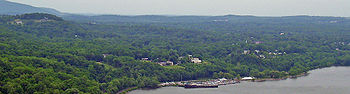 Cornwall on Hudson seen from Breakneck Ridge, across the river
Contents
History
The village was part of the Governor Dongan tract of 1685.
Cornwall-on-Hudson set itself off from the Town of Cornwall in 1885 by incorporating as a village.
People of note, past and present in Cornwall-on-Hudson
- Djuna Barnes, (1892–1982) writer in Greenwich Village and Paris.
- Larry David, (born 1947), television actor, producer and writer; attended summer camp in 1960.
- Larry Desmedt(Indian Larry), (1949-2004) noted custom bike builder and stuntman.
- William Frederick Hoppe (1887–1959) known as Willie Hoppe, professional carom billiards champion [1]
- Richard Lewis, (born 1947), comedian, attended summer camp in 1960.
- Albrect Pagenstecher[2] founder of International Paper
- David Petraeus, (born 1952), U.S. Army general, was born and raised in Cornwall-on-Hudson.
- Edward Payson Roe, (1838–1888) lived in the village while writing novels and botanical books.
- Malcolm Fraser (philanthropist), (1903–94), philanthropist
- Nathaniel Parker Willis, (1806–1867) writer, editor, and poet[3]
- Donald Trump, attended local Military Academy.
Geography
Cornwall-on-Hudson is located at 41°26′33″N 74°00′50″W / 41.442589°N 74.013898°WCoordinates: 41°26′33″N 74°00′50″W / 41.442589°N 74.013898°W (41.442589, -74.013898).[4]
According to the United States Census Bureau, the village has a total area of 2.1 square miles (5.4 km2), of which, 2.0 square miles (5.2 km2) of it is land and 0.1 square miles (0.26 km2) of it (5.31%) is water. The zip code is 12520.
Located just 50 miles (80 km) north of New York City, the village borders the west shore of the Hudson River. It is one of the most affluent communities in the Orange County area. While the village is primarily residential, there is a small commercial center and many riverfront homes adjacent to Donahue Memorial Park.
NY-218 passes through the village and US Route 9W passes around the west side.
Storm King State Park lies south of the village, and, below that, the United States Military Academy.
Demographics
As of the census[5] of 2000, there were 3,058 people, 1,181 households, and 824 families residing in the village. The population density was 1,560.9 people per square mile (602.4/km2). There were 1,233 housing units at an average density of 629.4 per square mile (242.9/km2). The racial makeup of the village was 96.63% White, 0.39% African American, 0.29% Native American, 0.65% Asian, 0.03% Pacific Islander, 0.85% from other races, and 1.14% from two or more races. Hispanic or Latino of any race were 3.79% of the population.
There were 1,181 households out of which 34.2% had children under the age of 18 living with them, 58.0% were married couples living together, 8.9% had a female householder with no husband present, and 30.2% were non-families. 25.8% of all households were made up of individuals and 9.5% had someone living alone who was 65 years of age or older. The average household size was 2.58 and the average family size was 3.14.
In the village the population was spread out with 27.0% under the age of 18, 5.6% from 18 to 24, 27.9% from 25 to 44, 26.3% from 45 to 64, and 13.3% who were 65 years of age or older. The median age was 39 years. For every 100 females there were 91.2 males. For every 100 females age 18 and over, there were 90.5 males.
The median income for a household in the village was $75,300, and the median income for a family was $88,000. Males had a median income of $55,000 versus $37,857 for females. The per capita income for the village was $31,272. About 2.6% of families and 3.9% of the population were below the poverty line, including 2.8% of those under age 18 and 3.5% of those age 65 or over.
Schools
- New York Military Academy (private, boarding)
- Storm King School (private, boarding)
- St. Thomas of Canterbury (private)
- Cornwall-on-Hudson Elementary School
- Lee Road Elementary School
- Cornwall Central Middle School
- Cornwall Central High School
References
- ^ Encyclopedia Britannica, http://www.britannica.com/EBchecked/topic/271585/Willie-Hoppe
- ^ http://cornwall-on-hudson.com/article.cfm?page=712
- ^ Ehrlich, Eugene and Gorton Carruth. The Oxford Illustrated Literary Guide to the United States. New York: Oxford University Press, 1982: 106. ISBN 0195031865
- ^ "US Gazetteer files: 2010, 2000, and 1990". United States Census Bureau. 2011-02-12. http://www.census.gov/geo/www/gazetteer/gazette.html. Retrieved 2011-04-23.
- ^ "American FactFinder". United States Census Bureau. http://factfinder.census.gov. Retrieved 2008-01-31.
External links
Municipalities and communities of Orange County, New York Cities 
Towns Blooming Grove | Chester | Cornwall | Crawford | Deerpark | Goshen | Greenville | Hamptonburgh | Highlands | Minisink | Monroe | Montgomery | Mount Hope | New Windsor | Newburgh | Tuxedo | Wallkill | Warwick | Wawayanda | Woodbury
Villages Chester | Cornwall-on-Hudson | Florida | Goshen | Greenwood Lake | Harriman | Highland Falls | Kiryas Joel | Maybrook | Monroe | Montgomery | Otisville | South Blooming Grove | Tuxedo Park | Unionville | Walden | Warwick | Washingtonville | Woodbury
CDPs Other
hamletsAmity | Arden | Bellvale | Bullville | Circleville | Howells | Little Britain | Michigan Corners | Mountain Lodge Park | Mountainville | New Hampton | Pine Island | Ridgebury | Slate Hill | Sugar Loaf | Thompson Ridge | Westbrookville
Categories:- Villages in New York
- Cornwall, New York
- Populated places on the Hudson River
- Poughkeepsie–Newburgh–Middletown metropolitan area


Wikimedia Foundation. 2010.