- Bridgeport, Connecticut
-
"Bridgeport" redirects here. For other uses, see Bridgeport (disambiguation).
City of Bridgeport — City — 
Flag
SealNickname(s): The Park City, The Port, B-Port, BPT Location in Fairfield County, Connecticut
Coordinates: 41°11′11″N 73°11′44″W / 41.18639°N 73.19556°WCoordinates: 41°11′11″N 73°11′44″W / 41.18639°N 73.19556°W Country United States State Connecticut County Fairfield NECTA/MSA Bridgeport-Stamford Region Greater Bridgeport, Greater New York Incorporated (town) 1821 Incorporated (city) 1836 Government – Type Mayor-council – Mayor Bill Finch Area – City 19.4 sq mi (50.2 km2) – Land 16.0 sq mi (41.4 km2) – Water 3.4 sq mi (8.8 km2) – Urban 9,014.3 sq mi (3,843.8 km2) Elevation 3 ft (1 m) Population (2010)[1] – City 144,229 – Density 8,720.9/sq mi (3,354/km2) – Metro 916,829 Time zone Eastern (UTC-5) – Summer (DST) Eastern (UTC-4) ZIP code 06601, 06602, 06604, 06606, 06607, 06608, 06610, 06650, 06673, 06699[2] Area code(s) Area codes 203 and 475 FIPS code 09-08000 GNIS feature ID 0205720 Website www.bridgeportct.gov Bridgeport is the most populous city in the U.S. state of Connecticut. Located in Fairfield County, the city had an estimated population of 144,229 at the 2010 United States Census[1] and is the core of the Greater Bridgeport area. The city is part of the Greater New York City Combined Statistical Area and the fifth largest city in New England (behind, in order: Boston, Worcester, Providence, and Springfield.) Bridgeport is also the center of the 41st largest urban area in the United States, just behind Austin, Texas (40th).
The city is marked by its attachment to its famous resident, the circus-promoter and once mayor P.T. Barnum. Barnum built three houses in the city, and housed his circus in town during winters.
Other than Black Rock and parts of Brooklawn which were originally part of the township of Fairfield, Bridgeport was originally a part of the township of Stratford. The first English settlement on the west bank of the mouth of the Pequonnock River was made somewhere between 1639 and 1665 and was called Pequonnock.[3][4] This village was renamed Newfield sometime before 1777.[5] More people settled further inland and to the West and the area officially became known as Stratfield in 1701, likely due to its location between the already existing towns of Stratford and Fairfield.[6] During the American Revolution, Bridgeport was a center of privateering.[4] In 1800, Newfield village was chartered as the borough of Bridgeport, and in 1821 the township of Bridgeport, including more of Stratfield, was incorporated. Finally, Bridgeport was chartered as a city in 1836.[7]
The city was home to the Frisbie Pie Company, and therefore it has been argued that Bridgeport is the birthplace of the frisbee.[8]
The city is also home to the first Subway Restaurant, opened in the North End section of the city in 1965.[9]
Contents
History
Main article: History of Bridgeport, ConnecticutEarly years
Bridgeport's early years were marked by residents' reliance on fishing and farming. The city's location on the deep Newfield Harbor fostered a boom in shipbuilding and whaling in the mid-19th century, especially after the opening of a railroad to the city in 1840.[10][11]
The city rapidly industrialized in the late-19th century, when it became a manufacturing center. It produced such goods as the famous Bridgeport milling machine, brass fittings, carriages, sewing machines, brassieres, saddles, and ammunition.[12] Bridgeport annexed the village of Black Rock and its busy harbor in 1870.[13]
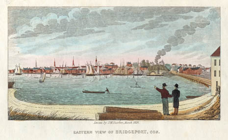
 Eastern View of Bridgeport, Con. by John Warner Barber (1836)
Abraham Lincoln's visit
On Saturday, March 10, 1860, Abraham Lincoln spoke in the city's Washington Hall, an auditorium at the old Bridgeport City Hall (now McLevy Hall), at the corner of State and Broad streets. Not only was the largest room in the city packed, but a crowd formed outside as well. Lincoln received a standing ovation before taking the 9:07 p.m. train that night back to Manhattan.[14][15] A plaque marks the site where Lincoln spoke. Other notables who have given speeches in Bridgeport include Martin Luther King, Jr. who spoke three times at the Klein Auditorium in the 1960s;President Obama also spoke at the Harbor Yard arena in 2010 to gain support for the current running democratic Governor Dan Malloy.[16] and President George W. Bush who spoke before a small, selected group of Connecticut business people and officials at the Playhouse on the Green, just across the street from McLevy Hall, in 2006.[17]
Industrialization and labor history
Industrialization started taking place in the mid-19th century. Famous factories included Wheeler & Wilson, which produced sewing machines and exported them throughout the world, and the Locomobile Company of America, builder of one of the premier automobiles in the early years of the century.[18]
In the summer of 1915, amid increased labor demand for World War I, a series of strikes demanding the eight-hour day began in Bridgeport. They were so successful that they spread throughout the Northeast.[19]
By 1930, Bridgeport was a thriving industrial center with more than 500 factories. Since the late 19th century, its industrial jobs had attracted the most recent immigrants: Irish, Italians and eastern Europeans. The build-up to World War II further helped its industries.[20]
Deindustrialization
Restructuring of heavy industry starting after the mid-20th century caused the loss of thousands of jobs and residents. Like other urban centers in Connecticut, Bridgeport suffered during the deindustrialization of the United States in the 1970s and 1980s.[21] Suburban flight as well as overall mismanagement, for which several city officials were convicted, contributed to the decline.[22]
In September 1978, Bridgeport teachers went on a 19-day strike due to deadlocked contract negotiations. A court order, as well as state law that made strikes illegal in Connecticut, resulted in 274 teachers being arrested and jailed.[23]
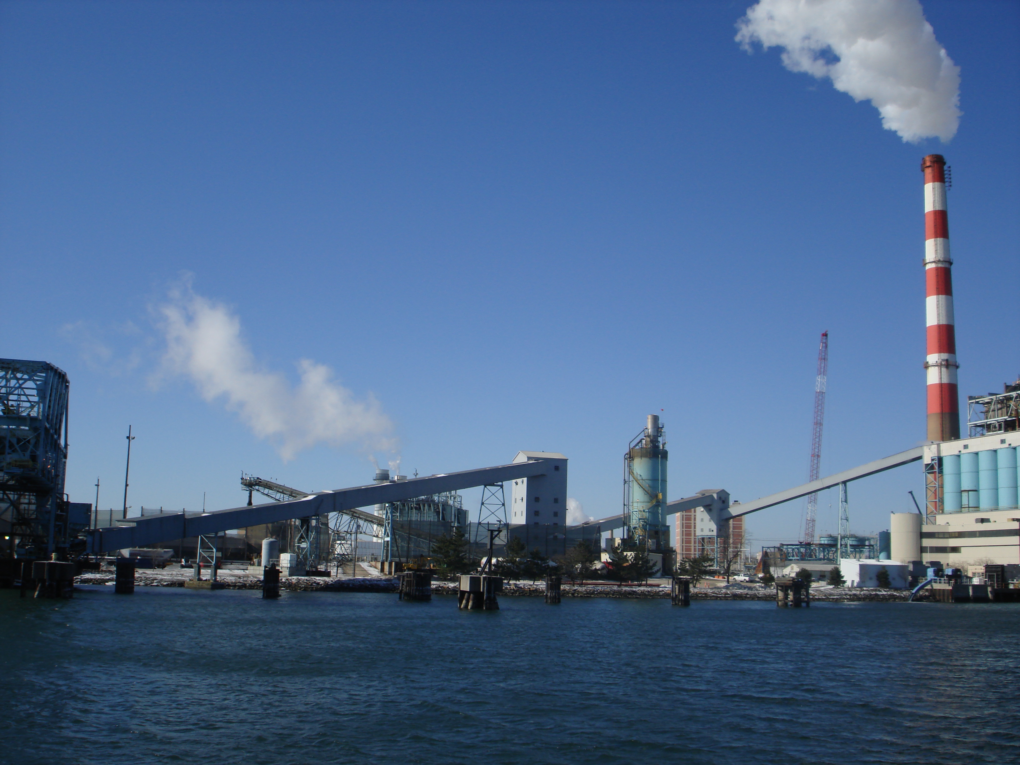
 A portion of the harbor in Bridgeport. Facilities shown are part of the United Illuminating coal-fired power plant
Like other northeastern cities suffering from the effects of Post World War II industrial decline, Bridgeport made numerous efforts at revitalization. In one proposal Las Vegas developer Steve Wynn was to build a large casino, but that project failed to materialize. In 1991, the city filed for bankruptcy protection but was declared solvent by a federal court.[24]
Twenty-first century
In the early 21st century, Bridgeport is a city that despite the longtime burdens of crime, poverty and corruption has taken steps toward redevelopment of its downtown and other neighborhoods. In 2004, artists' lofts in the former Read's Department Store on Broad Street first became available. Several other rental conversions have been completed, including the 117 unit Citytrust bank building on Main Street. The recession has halted, at least temporarily, two major mixed-use projects including a $1 billion waterfront development at Steel Point, but other redevelopment projects have proceeded, albeit slowly, such as the condominium conversion project in Bijou Square.[25] In 2009, the City Council approved a new master plan for development designed both to promote redevelopment in selected areas and to protect existing residential neighborhoods.[26] In 2010, the Bridgeport Housing Authority and a local health center announced plans to build a $20 million medical and housing complex at Albion Street, making use of federal stimulus funds and designed to replace some of the housing lost with the demolition of Father Panik Village.[27]
Emergency services
Fire department
The city of Bridgeport is protected 24/7 by the 350 professional firefighters of the Bridgeport Fire Department(BFD). The Bridgeport Fire Department operates out of 8 Fire Stations, located throughout the city, in 2 Battalions. The BFD operates a fire apparatus fleet of 9 Engines(Including 1 Quint), 4 Ladders, 1 Rescue, 1 Command Vehicle, 1 Haz-Mat. Unit, 3 Fireboats, and numerous special, support, and reserve units. In 2010, the Bridgeport Fire Department responded to over 13,000 emergency calls. The current Chief of Department is Brian Rooney.[28][29]
Two Bridgeport firefighters, Lt. Steven Velasquez and Firefighter Michel Baik, died while fighting a fire at 41 Elmwood Ave. Saturday afternoon (07/24/2010). In a residential structure fire, they had been trapped on the 3rd floor while checking for hotspots and trapped victims. [30]
Engine Company Ladder Company Special Unit Battalion Address Neighborhood Engine 1 Ladder 5 Rescue 5, Marine 2 Battalion 1, Deputy 1 30 Congress St. Downtown Engine 3, Engine 4 Haz-Mat./Decon. Unit 233 Wood Ave. West Side Engine 6 Ladder 6 Marine 3 Battalion 2 1035 Central Ave. East End Engine 7 Ladder 11 Command Vehicle 245 Ocean Terr. Black Rock Engine 10 Ladder 10 Marine 1 950 Boston Ave. East Side Engine 12 265 Beechmont Ave. Brooklawn Engine 15 104 Evers St. North Bridgeport Engine 16(Quint) 3115 Madison Ave. North End Law enforcement
There are 5 law enforcement agencies that serve Bridgeport. Two at the city level, one at the county level, and two at the state level.
City level:
- Bridgeport Police Department – The cities primary law enforcement agency, it deals with every-day things in the city from gang violence to petty theft.
- Bridgeport Park Police Department – A separate department from the Bridgeport Police, this agency was formed to enforce law in Bridgeport's vast area of city parks.
County level:
- Fairfield County Marshal – Fairfield Judicial District – This agency is responsible for judicial process and most arrest warrants in the south eastern portion of Fairfield County that is also adjacent to the borders of the Greater Bridgeport Regional Planning Agency.
State level:
- Connecticut State Police – Maintains one of the twelve state-wide troop barracks in Bridgeport. Responsible for highway patrol and assisting the Bridgeport Police Department and surrounding municipalities when needed for situations such as stand offs.
- New York Metropolitan Transportation Authority Police – District #8 is responsible for the security of the New York Metropolitan Transportation Services. This agency is limited to downtown around the Bridgeport (Metro-North station).
Law enforcement agencies in Fairfield County, Connecticut State Level County Level Fairfield County Sheriff's Department • Fairfield County MarshalTown/City Level Bethel Police Department • Bridgeport Police Department • Bridgeport Park Police Department • Bristol Police Department • Brookfield Police Department • Danbury Police Department • Darien Police Department • Easton Police Department • Fairfield Police Department • Greenwich Police Department • New Canaan Police Department • Newtown Police Department • Norwalk Police Department • Ridgefield Police Department • Shelton Police Department • Shelton Sheriff's Department • Stamford Police Department • Stratford Police Department • Weston Police Department • Westport Police Department • Wilton Police Department • Trumbull Police DepartmentUniversity Level Western Connecticut State University Police Department • Sacred Heart University Public SafetyMedical care
The community has two hospitals, Bridgeport Hospital and St. Vincent's Medical Center. The former Park City Hospital closed in 1993 and was reopened in 2010 as elderly and homeless housing units.[31]
Animal control
Animal Control has been located for many years at 525 Asylum St. and on June 2008 the animal shelter which is now referred to as Bridgeport Animal Control has moved to 236 Evergreen St. This location was the previous housing quarters for the Shoreline Star Greyhounds. This location once housed over 800 dogs. The Animal Control facility is currently the largest in the state of Connecticut. Over 1500 to 2000 animals are brought in yearly. The new facilities currently consist of three buildings. An Administration building, and two animal holding buildings. One is used as a quarantine building for the 7 day holding period and the second is the adoption building. The new shelter can house up to 80 dogs and 25 cats. During the beginning of the project the facility was planning on holding 52 cats in a fourth building but there wasn't enough money in the budget. The Director of the Animal shelter is referred to as the Chief Animal Control officer and his assistant officers are referred to as AACO's (Assistant Animal Control officers) The largest breed of dog the shelter deals with, is the "Pitbull." The BAC does not pick up cats unless they are sick or injured and this is also the same policy for wildlife.[32]
Geography and climate
Bridgeport is located along Long Island Sound at the mouth of the Pequonnock River.
According to the United States Census Bureau, the city has a total area of 19.4 square miles (50 km2), of which 16.0 square miles (41 km2) is land and 3.4 square miles (8.8 km2), or 17.53%, is water. Bridgeport lies within the transition zone between a humid subtropical and a humid continental (Köppen Cfa/Dfa), with very warm and humid summers and cold, snowy winters. Although the seasonal extremes are slightly moderated by Long Island Sound, the primary annual weather pattern flow is offshore, from the colder landmasses to the north and west. The adjacent waters result in Bridgeport being several degrees cooler in summer and slightly milder with less snowfall in winter than locations further away from the coast. The city receives 41.7 inches (1,060 mm) of precipitation and 24.8 inches (63 cm) of snowfall in an average year. The snowiest winter on record is 1996 where Bridgeport received 76.8 inches (195 cm).[33] Bridgeport's highest temperature is 103 °F (39 °C) in July 1957 and the lowest temperature is −7 °F (−22 °C) in January 1984.
Climate data for Bridgeport, Connecticut Month Jan Feb Mar Apr May Jun Jul Aug Sep Oct Nov Dec Year Record high °F (°C) 68
(20)67
(19)84
(29)91
(33)97
(36)97
(36)103
(39)100
(38)99
(37)89
(32)78
(26)76
(24)103
(39)Average high °F (°C) 36.9
(2.7)38.8
(3.8)46.9
(8.3)57
(14)67.4
(19.7)76.4
(24.7)81.9
(27.7)80.7
(27.1)73.6
(23.1)63.1
(17.3)52.6
(11.4)42.1
(5.6)59.8 Average low °F (°C) 22.9
(−5.1)24.9
(−3.9)32
(0)40.7
(4.8)50.6
(10.3)59.6
(15.3)66
(19)65.4
(18.6)57.7
(14.3)46.3
(7.9)37.5
(3.1)28
(−2)44.3 Record low °F (°C) −7
(−22)−5
(−21)4
(−16)18
(−8)31
(−1)41
(5)49
(9)44
(7)36
(2)26
(−3)16
(−9)−4
(−20)−7
(−22)Precipitation inches (mm) 3.73
(94.7)2.92
(74.2)4.15
(105.4)3.99
(101.3)4.03
(102.4)3.57
(90.7)3.77
(95.8)3.75
(95.3)3.58
(90.9)3.54
(89.9)3.65
(92.7)3.47
(88.1)44.15
(1,121.4)Snowfall inches (cm) 8.5
(21.6)7.2
(18.3)4.3
(10.9)0.9
(2.3)0
(0)0
(0)0
(0)0
(0)0
(0)0
(0)0.7
(1.8)3.2
(8.1)24.8
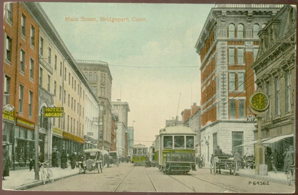
(63)Avg. precipitation days 11 9.8 11.1 10.3 11.4 10.7 8.5 9.2 8.6 8.2 9.8 11.4 120 Avg. snowy days 5.3 4.4 2.5 0.4 0 0 0 0 0 0 0.7 2.9 16.2 Source: NOAA [34]  1912 postcard showing Main Street in Bridgeport
Cityscape
The Bridgeport Harbor is bordered by the Long Island Sound and is formed by the estuary of the Pequonnock River and Yellow Mill Pond, an inlet. Between the estuary and the pond is a peninsula, East Bridgeport, also known as the East Side, which was once the site of some of the largest manufacturing establishments in Connecticut, most of which no longer exist. On the other side of the Yellow Mill Pond inlet is the East End of Bridgeport, which is the far Eastern point of the city, next to Pleasure Beach Island. Above the East End are the Mill Hill and Boston Avenue neighborhoods and the border with Stratford, Connecticut. West of the Harbor and the Pequonnock River is the main portion of the city, with Downtown Bridgeport lining the river, the South End lining the harbor and Long Island Sound, the West Side between Fairfield, Connecticut and Downtown, and North Bridgeport extending from Downtown and the West Side to the border with Trumbull, Connecticut. Numerous factories, some of which are no longer in operation, line western sections the Metro North/New Haven Railroad line from the Bridgeport Station in Downtown, under Interstate 95 in the South End, and through the West Side and into Fairfield. The city is surrounding by hills in North Bridgeport/North End, the Upper East Side, and Mill Hill.
The main portion of the city is divided into three major North/South roads that somewhat parallel each other. Main Street, the city's main artery, extending from the Trumbull town line, down through North Bridgeport, under Route 25 and into Downtown, ending at the Harbor Yard Arena in the South End. Park Avenue is the far western main road that is on the borderline with the town of Fairfield and extends from the Easton, Connecticut border in the North End to the West Side. Madison Avenue is situated parallel between Main Street and Park Avenue that extends from the Trumbull town line in the North End and continues through the West Side. East Main Street is the major North/South road through East Bridgeport, extending from the Trumbull/Stratford line though the East Side, ending near Steel Point. The major East/West roads in the city are Barnum Avenue, Boston Avenue, Fairfield Avenue/Stratford Avenue, North Avenue, Capitol Avenue, State Street, and Railroad Avenue. Barnum Avenue extends from the Stratford line, below Mill Hill, and ends at the Pequonnock River. Boston Avenue breaks off of Barnum Avenue at the Stratford line and goes Northwest through the Upper East Side into the North End. Stratford Avenue starts in the South End of the town of Stratford and travels Southwest into Bridgeport, where it briefly becomes Connecticut Avenue in the city's East End. It then travels East through Steel Point directly into the center of Downtown Bridgeport, where it turns into Fairfield Avenue at Main Street. Fairfield Avenue then travels South and then Southwest through the West Side and down into Black Rock, where it turns into the Boston Post Road, or simply, the Post Road, in Fairfield, Connecticut. North Avenue begins at Boston Avenue in the Upper East Side above the Pequonnock River and extends Southwest diagonally through the city as Route 1. Like Fairfield Avenue, it then turns into the Post Road in Fairfield. Capitol Avenue begins by breaking off of North Avenue at Barnum Avenue and travels West across the Madison and Brooklawn neighborhoods near North Bridgeport and ends at the Fairfield line. State Street begins in Downtown and cuts across the West Side, where it terminates in Fairfield. Railroad Avenue extends from just below Downtown Bridgeport and runs parallel with the Metro North/New Haven Railroad lines. The Westbound side above the tracks, and the Eastbound side below the tracks. It terminates at Fairfield Avenue in the West Side.
There are two large parks in Bridgeport, the Park City. Beardsley is in the extreme northeastern part of the city and also contains Connecticut's only zoo, the Beardsley Zoo. It also borders a large reservoir. Seaside is west of the harbor entrance and along the Sound in the South End. It has statues in honor of Elias Howe, who built a large sewing-machine factory in 1863; and of P.T. Barnum, the showman, who lived in Bridgeport after 1846. He contributed much to the city, especially East Bridgeport. Seaside Park also has a soldiers' and sailors' monument. In the vicinity are many upscale residences.
Aside from the Pequonnock River and the Yellow Mill Pond, there is Cedar Creek. Cedar Creek is a lake-like tidal creek that lies between Black Rock and Seaside Park. Black Rock Harbor lies at the mouth of the creek.[35]
The principal municipal buildings in Bridgeport are the city's two hospitals (St. Vincent's Medical Center and Bridgeport Hospital), the Protestant orphan asylum, the Barnum Institute (occupied by the Bridgeport Scientific and Historical Society), the Bridgeport Medical Society, City Hall, the Fairfield County Courthouse, the Barnum Museum, and the United States Customs House, which also contains a post office.
 Historical postcard showing Bridgeport Harbor
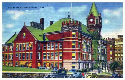
 1941 postcard showing Fairfield County Courthouse in Bridgeport
Neighborhoods
Bridgeport is made up of approximately 70 distinct neighborhoods and districts.
- Downtown Bridgeport
- Central Business District
- Historic Downtown North
- The Hollow
- Bull's Head
- Enterprise Zone
- Golden Hill
- Hollow Proper (Golden Valley)
- Sterling Hill
- The Greene Homes (Housing Project)
- Housatonic Community College Campus
- East Bridgeport/East Side/East End
- Beardsley Park
- Boston Avenue
- Briarwood/Treeland
- Remington Woods
- Success Lake/Success Village
- Harborview Towers
- Lower East Side
- Mill Hill
- Newfield
- Newpasture Point
- Steel Point
- Upper East Side
- Washington Park
- West Side/West End
- Black Rock
- Black Rock Gardens
- Captains Cove
- Grover's Hill/St. Mary's by-the-Sea
- P.T. Barnum (Housing Project)
- Brooklawn
- Mountain Grove
- Meetinghouse Hill
- Black Rock
- South End
- Liberia (Ethiope)
- Marina Village (Housing Project)
- Seaside Village
- Seaside Park
- Tongue Point
- University of Bridgeport Campus/Marina Park
- William D. Bishop Cottage Park Historical District
- North Bridgeport/North End
- Beardsley Terrace/Trumbull Gardens (Housing Project)
- Beechmont Gardens
- Brookside
- Charcoal Pond
- Chestnut Hill
- Cow Hill
- Island Brook (Berkshire)
- Lake Forest (www.lakeforestassociation.com)
- Little Italy
- Ox Hill
- Rocky Hill/Sylvan Crest
- St. Vincent's
- Toilsome Hill
- Whiskey Hill
Islands
- Fayerweather Island is connected to Seaside Park by a seawall and is home to the Black Rock Harbor Light.
- Pleasure Beach (also known as Steeplechase Island), is located in Long Island Sound, below the city's East End, and is connected by the Long Beach peninsula to Stratford, Connecticut.
Demographics
Historical populations Census Pop. %± 1840 3,294 — 1850 6,080 84.6% 1860 12,106 99.1% 1870 18,969 56.7% 1880 27,643 45.7% 1890 48,866 76.8% 1900 70,996 45.3% 1910 102,054 43.7% 1920 143,555 40.7% 1930 146,716 2.2% 1940 147,121 0.3% 1950 158,709 7.9% 1960 156,748 −1.2% 1970 156,542 −0.1% 1980 142,546 −8.9% 1990 141,686 −0.6% 2000 139,529 −1.5% 2010 144,229 3.4% Population 1840–1970[1][36] As of the census[37] of 2000, there were 139,529 people, 50,307 households, and 32,749 families residing in the city. The population density was 8,720.9 people per square mile (3,367.0/km²). There were 54,367 housing units at an average density of 3,398.1 per square mile (1,312.0/km²). The racial makeup of the city was 45.02% White, 30.76% African American, 0.48% Native American, 3.25% Asian, 0.11% Pacific Islander, 14.81% from other races, and 5.57% from two or more races. Hispanic or Latino of any race were 31.88% of the population. Other ancestry groups include: Italian (8.6%), Irish (5.1%), Portuguese (2.9%), Polish (2.8%), and German (2.4%). [1]
 A typical street scene in Bridgeport
There were 50,307 households out of which 34.3% had children under the age of 18 living with them, 35.0% were married couples living together, 24.0% had a female householder with no husband present, and 34.9% were non-families. 29.0% of all households were made up of individuals and 11.3% had someone living alone who was 65 years of age or older. The average household size was 2.70 and the average family size was 3.34.
In the city the population was spread out with 28.4% under the age of 18, 11.2% from 18 to 24, 30.5% from 25 to 44, 18.4% from 45 to 64, and 11.5% who were 65 years of age or older. The median age was 31 years. For every 100 females there were 91.2 males. For every 100 females age 18 and over, there were 86.3 males.
The median income for a household in the city was $34,658, and the median income for a family was $39,571. Males had a median income of $32,430 versus $26,966 for females. The per capita income for the city was $16,306. About 16.2% of families and 18.4% of the population were below the poverty line, including 24.8% of those under age 18 and 13.2% of those age 65 or over.
According to 2010 census data, Bridgeport is the most unequal city in America.[38][39]
Voter Registration and Party Enrollment as of October 25, 2005[40] Party Active Voters Inactive Voters Total Voters Percentage Democratic 33,374 2,855 36,229 58.23% Republican 5,069 468 5,537 8.90% Unaffiliated 18,538 1,887 20,425 32.83% Minor Parties 27 3 30 0.05% Total 57,008 5,213 62,221 100% Economy
Top employers
According to the City's 2009 Comprehensive Annual Financial Report,[41] the top employers in the city are:
# Employer # of Employees St. Vincent's Medical Center 3,000 Bridgeport Hospital 2,622 People's United Bank 1,179 University of Bridgeport 875 Bridgeport Health Care Center 500 Housatonic Community College 482 Prime Line 310 Derecktor Shipyards 300 Lacey Manufacturing 275 Watermark Retirement Communities 165 Education
Main article: Education in Bridgeport, ConnecticutHigher education
Bridgeport is home to Housatonic Community College, St. Vincent's College, University of Bridgeport and the Yeshiva Gedola of Bridgeport.
Public education
The city's public school system has 30 elementary schools, three comprehensive high schools, two alternative programs and an interdistrict vocational aquaculture school. The system has about 20,800 students, making the Bridgeport Public Schools the second largest school system in Connecticut after Hartford. It is ranked #158 out of the 164 Connecticut school districts.[42] The school system employs a professional staff of more than 1,700.
The city has started a large school renovation and construction program, with plans for new schools and modernization of existing buildings.
High schools
- Bassick High School
- Central High School established in 1876, home to Central Magnet, largest of the high schools
- Warren Harding High School home to the International Baccalaureate Program (IBO) and the Health Magnet Program in association with Bridgeport Hospital, St. Vincent’s Medical Center, and Bridgeport Manor.
- Bridgeport Regional Vocational Aquaculture School (BRVAS), a school specializing in marine and aquaculture curriculum. located near historic Captain's Cove and open to students from surrounding towns.
- Bullard Havens Technical High School, a vocational high school. (State School)
- Kolbe Cathedral High School, Bridgeport's sole Catholic high school
- The Bridge Academy: Bridgeport's sole Charter High School
- Bridgeport International Academy
Private education
Bridgeport is also home to several Religious schools and Private learning institutes, some including the Jewish High School of Connecticut, Bridgeport Hope School(k-8), Bridgeport International Academy(9–12), Kolbe Cathedral High School, Zion Lutheran School(PK-8), St. Ambrose, St. Raphael's, St. Augustine, St. Andrew's, St. Peter's, and St. Ann.
Government and politics
The city is governed by the mayor council system. There are twenty members of the city council elected from districts. Each district elects two members. The mayor is elected by the entire city.
Bridgeport is notable for having had a Socialist mayor for 24 years; Jasper McLevy served as mayor from 1933 to 1957. A more recent mayor, Joseph Ganim, was involved in a corruption scandal, as has been the case with some other mayors in Connecticut.[43] In June 2006, Mayor John M. Fabrizi admitted that he had used cocaine while in office.[44]
Culture
 Barnum Museum
Performing arts
Theater and music
Bridgeport has a number of venues for live theater and music events, ranging from intimate performing spaces to a stadium hosting rock concerts.[45]
- Downtown Cabaret Theatre – cabaret, children's theater, concerts.
- Playhouse on the Green – (228 seats) theater with plays and varied musical events.
- Klein Memorial Auditorium – (1400 seats) home to the Greater Bridgeport Symphony, touring shows and concerts.
- Arena at Harbor Yard – Sporting events venue, but also hosts large concerts.
Music festivals and concert series
Bridgeport has been the annual home to Gathering of the Vibes, a weekend long arts, music and camping festival featuring some of the best names in festival talent. In 1999, 2000, and 2007 through 2010, thousands of people have come from all over the world to camp in Seaside Park and enjoy such talent as Buddy Guy, Bob Weir and Ratdog, Deep Banana Blackout, Les Claypool, Assembly of Dust, Dirty Dozen Brass Band, Los Lobos and Bridgeport's own The Alternate Routes.
Bridgeport is also the home of the Black Rock Art Center, a multi-cultural center that presents performing artists from Africa, Asia, the Caribbean and the Americas both at the Art Center and also in a Summer Sounds of the World concert series. The series has featured such artists as blues musician James Cotton, Grammy-award winner Eddie Palmieri, the Cambodian Angkor Dance Company, salsa master Larry Harlow, and folk artists Richie Havens and Odetta. The Art Center features a world music series, a cabaret series, the Black Rock Blues Festival, in addition to cinema, gallery, and educational programs.
Museums, zoos, and parks
Theater and music
Bridgeport has a number of museums, ranging from the science-oriented to fine arts and historical, as well as the state's largest zoo.[45]
- The Discovery Museum and Planetarium emphasizes exhibits on science, with the state's only Challenger Center, affiliated with the national space program.
- Housatonic Museum of Art, located at Housatonic Community College, has the largest collection of art of any two-year college in the nation.
- The Barnum Museum celebrates the showman, circuses and Bridgeport history.
- Beardsley Zoo is the only such center in Connecticut.
Parks
Further information: History of Bridgeport, ConnecticutBridgeport's first public park was the 4-acre (16,000 m2) Washington Park in East Bridgeport, first set aside as a park in 1851.[46] As the city rapidly grew in population, residents recognized the need for more public parks and by 1864, Barnum and other residents had donated approximately 35 acres (140,000 m2) to create Seaside Park, now increased to 375 acres (1.52 km2).[47] In 1878, over 100 acres (400,000 m2) of land bordering the Pequonnock River was added as Beardsley Park.[48] Frederick Law Olmsted, famous for creating New York City's Central Park, designed both Seaside and Beardsley Parks.[49] Over time, more parks were added including 35-acre (140,000 m2) Beechwood Park and Pleasure Beach, home to a popular amusement park for many years.
The "Park City" now has these parks:
- Alice Street Lot, located on Alice Street
- Baldwin Plaza, on Broad Street
- Beardsley Park, located on Noble Avenue where Harding High School plays Baseball and Softball games; picnic areas are also visible, located adjacent to Beardsley Zoo
- Beechwood Park, Madison Avenue, incorporating Kennedy Stadium
- Ellsworth Park, on Ellsworth Street
- Fairchild Memorial Park, located on Trumbull Road
- Glenwood Park, where tennis courts are abundant
- James Brown Park (Waterview Park), located on Waterview Avenue
- Johnson Oak Park on Logan Street (now part of the Tisdale Elementary School)
- Lafayette Park, located on Oak Street
- Longfellow Park, on St. Stephens Road
- Newfield/Jessup Park located on Newfield Avenue has a playground,
- Pleasure Beach is closed
- Puglio Park on Madison Avenue consecutive to the North End Library
- Rogers Elton Park on Frenchtown Road
- Seaside Park, the largest park in Bridgeport with baseball/softball/soccer fields, fishing areas, picnic areas, playgrounds, Groomed beach and swimming, and boat launch stretching from Bridgeport Harbor to Black Rock Harbor
- Saint Mary's-By-the-Sea located on Grovers Avenue
- Success Park on Granfield Street
- Svihra Park on Ezra Street
- Upchurch Park on Hallett Street
- Wood Park on Wood Avenue
- Veteran's Memorial Park, formerly, 90 Acres Park, runs between Park and Madison Avenues in the North End (undeveloped/reclaimed)
- Washington Park located on East Washington Avenue
- Waterfront Park located on Water Street primarily for baseball usage
- Went Field Park on Wordin Avenue (play area, Baseball/softball was Barnum's Circus winter grounds
- West Side 2 Park located on Bostwick Avenue
In popular culture
- The city was mentioned at the beginning of Mark Twain's novel, A Connecticut Yankee in King Arthur's Court.[50]
- In Stephen King's short story "I Know What You Need," the protagonist Elizabeth and her suitor Ed first meet in elementary school in Bridgeport, where Ed's family had moved fleeing the gambling debt accumulated by his father.[51]
- The city is mentioned in a scene from the 1938 Katharine Hepburn/Cary Grant film, Bringing Up Baby.
- The character Joseph Wykowski in Neil Simon's play Biloxi Blues was from Bridgeport.[52]
- The character Robert E. Hogan in Bernard Fein's television show Hogan's Heroes was from Bridgeport.
- The song "157 Riverside Avenue" by REO Speedwagon mentions Bridgeport. It gets its title from the address in the nearby town of Westport where the band was staying while they recorded their first album in Bridgeport in a studio run by Paul Leka.[53]
- The city and P.T. Barnum formed the portmanteau name of the ursine character, P.T. Bridgeport, from Walt Kelly's comic strip Pogo.
- Comedian Fred Allen once said, "Everywhere outside New York City is Bridgeport, Connecticut."[54]
- The TV series Family Guy took a shot at Bridgeport in its episode Road to the North Pole. After mistaking a tall gloomy factory for Santa's workshop, Stewie said, "This can't be Santa's Workshop, this looks like Bridgeport, Connecticut!" To which Brian replied, "Oh boy, here come the letters." The screen then portrays an enraged fan from the city with a thick New England Accent, writing a hate letter out loud as follows. "Dear 'Family Guy' Bastards, Who the hell do you think you are? I'll have you know that Bridgeport is among the world leaders in abandoned buildings, shattered glass, boarded up windows, wild dogs and gas stations without pumps..." [55][56] The series' creator Seth MacFarlane is a Connecticut native from Kent.
- Bridgeport is an address listed on a piece of evidence in the 2011 detective video game, L.A. Noire.
- Bridgeport Harbor is referenced in Die Hard 3, and is where Jon McClain is rescued.
Movies filmed in Bridgeport
A list of films shot or partially filmed in the city:[57]
- A Dance for Grace (2010)
- Ironmen (2010)
- 3 Weeks to Daytona (2009)
- Accidental Mayor (2009)
- All Good Things (2009)
- Confessions of a Shopaholic (2009)
- Dear Beautiful (2009)
- The Godfather Musical Part III: Luca Brasi Sleeps with the Fishes (2009)
- House of Satisfaction (2009)
- Made for Each Other (2009)
- The Music of Erich Zann (2009/II)
- Old Dogs (2009/I)
- College Road Trip (2008)
- Indiana Jones and the Kingdom of the Crystal Skull (2008)
- Pistol Whipped (2008)
- Righteous Kill (2008)
- The Sisterhood of the Traveling Pants 2 (2008)
- What Just Happened (2008)
- Bobby Dogs (2007)
- Dear Beautiful (2007)
- Praying to Hendrix (2007)
- A Walk with Death (1993)
- Route One USA (1989)
- There's a Nightmare in My Closet (1987)
- Without a Trace (1983)
- The Case of the Cosmic Comic (1976)
- The Effect of Gamma Rays on Man-in-the-Moon Marigolds (1972)
- The Light that Failed (1916)
Television filmed in Bridgeport
- Brian Boitano Skating Spectacular (2010) (TV)
- Ghost Adventures:"Remington Arms Factory" (Episode 21, November 2009)
- WWE Raw is War (Dec. 19 2005, April 9, 2007 and April 27, 2009)
- Oprah Winfrey Presents: Mitch Albom's For One More Day (2007)
- WWE Raw's 15th Anniversary Special (2007)
- Flip This House: "Burning Down the House" (2005)
- Extreme Makeover: Home Edition (2003 & 2007)
- Made in America (2003)
- U.S. Bounty Hunter (2003)
- Muggsy (1976)
- The Twentieth Century (1957, The Class of '58 episode)
Sports
Club League Venue Established Championships Bridgeport Bluefish ALPB, Baseball The Ballpark at Harbor Yard 1998 1 Bridgeport Sound Tigers AHL, Ice hockey Arena at Harbor Yard 2001 0 The recently-built Arena at Harbor Yard serves as the city's sports and hospitality center. Seating 10,000, the Arena serves as the home rink of the Bridgeport Sound Tigers AHL hockey team, as well as the home court of the Fairfield University's basketball team.
The Ballpark at Harbor Yard serves as a minor-league baseball stadium, and was built in 1998 to serve as the homefield of the Bridgeport Bluefish. It is located downtown on a former brownfield site. It is visually prominent to commuters on I-95 or on passing trains.
Kennedy Stadium serves as a community sports facility. In the late 1960s and early 1970s, it was the home of an Atlantic Coast Football League minor league football team, the Bridgeport Jets, a New York Jets farm team also known locally as the Hi-Ho Jets due to their sponsorship by the (Hi-Ho) D'Addario construction company.
Fairfield University is located in the neighboring town of Fairfield, and many of the athletic teams play on campus. Only the men's and women's basketball teams play in Bridgeport.
Broadcast stations in the city
Radio
- WCUM AM 1450; 1,000 watts (formerly WJBX-AM, and before that, WNAB-AM) Spanish Format station better known as Radio Cumbre.
- WDJZ AM 1530; 5,000 watts (daytime only) Gospel Radio that serves the African American and Caribbean communities in the Bridgeport Metro area.
- WICC-AM 600; 1,000 watts (daytime), 500 watts (nighttime) – WICC began broadcasting on November 21, 1926, when a previous radio station, WCWS, was given a new name, WICC. The last three letters standing for Industrial Capitol of Connecticut. The Bridgeport Broadcasting Company Inc. was the new station's owner. Back then, the station was powered at 500 watts. From 1951 to 1956 one of the station's radio hosts was Bob Crane, who later went on to play Col. Robert Hogan on the Hogan's Heroes television comedy series.[58] WICC's transmitter is located on Pleasure Beach, an island located between downtown Bridgeport and Long Island Sound.
- WEBE-FM 107.9; 50,000 watts. WEBE 108 is "Connecticut's Best Music Variety!" owned and operated by Cumulus Media. Licensed to Westport, CT, with studios and transmitter in Bridgeport.
- WEZN-FM 99.9; 27,500 watts. STAR 99.9 is "Connecticut's Best Mix of the 80's, 90's and Today!" The station is owned by Cox Radio, Inc. Lincensed to Bridgeport, CT, with studios and transmitter in Milford.
- WPKN-FM 89.5; 10,000 watts; From the station's web site: "WPKN is somewhat inscrutable. We break all of the rules, and we observe few, if any, of the conventions. We have no format whatsoever, we permit our programmers to do whatever they will, and we don't accept funding from the sources which might restrict our freedoms. We are totally accountable to our listeners in that we publish our budget to everyone on our mailing list, and we also invite you to our monthly staff meetings and, in particular, the June meeting at which we discuss the budget. (...) WPKN's programming can be heard on two frequencies: 89.5 FM from our transmitter at Trumbull, CT and 88.7 FM (formally known as WPKM) at Montauk on Long Island. If you're driving eastward and you start to lose the 89.5 signal, you can tune over to 88.7 and continue to hear us until about Exit 6 on I-95 in Rhode Island."[59]
Due to Bridgeport's close proximity to Long Island Sound, many radio stations from New York are received clearly day and night in the market. These include WMCA, WFAN, WOR, WABC, WNYC, WCBS, WEPN, and WQEW.[60]
Radio stations in the Bridgeport, Connecticut market By FM frequency By AM frequency By callsign Bold stations are local to Bridgeport, most others are from New YorkWABC · WADS · WALK · WAXQ · WBAB · WBLI · WBLS · WBON · WCBS (AM) · WCBS-FM · WCCC · WCCC-FM · WCUM · WDJZ · WDRC · WDRC-FM · WEBE · WELI · WEMP · WEPN · WEZN · WFAN · WFIF · WFOX · WHCN · WHLI · WHTZ · WICC · WINS · WKCI-FM · WKLV-FM · WKTU · WLTW · WNYG • WOR · WPAT · WPAT-FM · WPKN · WPLJ · WPLR · WQHT · WQXR · WRKI · WRKS · WSHU-FM · WSHU (AM) · WSKQ · WURH · WWPR · WWPR-FM · WWYZ · WXRK · WYBC · WZMX
NYC Metro Markets : Long Island · Newburgh-Middletown · Poughkeepsie · Middlesex-Somerset-Union · Monmouth-Ocean · Morristown · Bridgeport · Danbury · New Haven · Stamford-NorwalkConnecticut Radio Markets: Bridgeport • Danbury • Hartford-New Britain-Middletown • New Haven • New London • Norwalk-Stamford
See also: List of radio stations in ConnecticutMedia
- Elsolnews.com, a community Spanish Language Weekly Newspaper covering news and events.
Television
- WEDW channel 49; one of the Connecticut Public Television stations, broadcasts from Bridgeport and can be seen in Hartford.
In 2011, WTNH-TV opened a satellite studio in the offices of the Connecticut Post downtown on State Street.
Transportation
Airports
Nearby Sikorsky Memorial Airport once provided regional flights to major hub cities such as Logan International Airport in Boston and Baltimore-Washington International Airport; however, service to the airport declined in the 1990s, and US Airways Express became the last airline to suspend operations at the airport in November 1999. Tweed New Haven Regional Airport is another nearby facility that provides scheduled air service. The closest international airports are Bradley International Airport in Windsor Locks, Connecticut, LaGuardia and John F. Kennedy in New York City and Newark in Newark, New Jersey.
Major highways
Bridgeport has several major roadways. Interstate 95 and the Route 8/Route 25 Connector meet in downtown Bridgeport. I-95 runs east-west near the coast heading towards New York City to the southwest and Providence to the northeast. Routes 8 and 25 run north-south across the city, with the two routes splitting just north of the city. Route 8 continues towards Waterbury and Torrington and Route 25 continues towards the Danbury area. Both Routes 8 and 25 connect to the Merritt Parkway in the adjacent town of Trumbull.
Other major surface arteries are U.S. 1 (the Boston Post Road), which runs east-west north of downtown, and Main Street, which runs north-south towards Trumbull center. The city also has several secondary state highways, namely, Route 127 (East Main Street), Route 130 (Connecticut Ave, Stratford Ave, Fairfield Ave and Water Street), and the Huntington Turnpike.
Railroad and ferries
 The Bridgeport Station is part of an intermodal transit hub
The city is connected to nearby New York City by both Amtrak and Metro-North commuter trains. Many residents commute to New York jobs on these trains, and the city to some extent is developing as an outpost of New York–based workers seeking cheaper rents and larger living spaces. Connecting service is also available to Waterbury via Metro-North, and New Haven via Amtrak and Metro-North. Shoreline East service links Old Saybrook and New London with New Haven, which extends to Bridgeport and Stamford during weekday rush hours only.
The Bridgeport & Port Jefferson Ferry service runs from Bridgeport across Long Island Sound to Port Jefferson, New York; the three vessels "Grand Republic", "P.T. Barnum" and "Park City" transport both automobiles and passengers.
Buses
The Greater Bridgeport Transit Authority (GBTA) provides bus service to Bridgeport and its immediate suburbs. Route 2 the Coastal Link goes west to Norwalk and east to Westfield's Connecticut Post Mall in Milford, from where Connecticut Transit can bring passengers to the New Haven Green. Greyhound and Peter Pan Bus Lines both offer intercity bus service to points throughout the Northeast and points beyond.
Historic sites
Bridgeport has a number of sites listed on the National Register of Historic Places:
- Berkshire No. 7 — boat, Bridgeport Harbor (added 1978)
- Barnum Museum — 805 Main St. (added December 7, 1972)
- Barnum/Palliser Historic District — Roughly bounded by Myrtle and Park Aves., Atlantic and Austin Sts. (both sides) (added 1982)
- Bassickville Historic District — 20–122 Bassick, 667–777 Howard, and 1521–1523 Fairview Aves., and 50-1380 State St. (added October 8, 1987)
- Beardsley Park — 1875 Noble Ave. (added April 18, 1999)
- Bikur Cholim Synagogue — 1545 Iranistan Ave. (added December 27, 1995)
- Black Rock Gardens Historic District — Bounded by Fairfield St., Brewster St. and Nash Ln., including Rowsley and Haddon Sts. (added October 26, 1990)
- Black Rock Historic District — Roughly bounded by Black Rock Harbor, Grovers Ave., Beacon and Prescott Sts. (added April 15, 1979)
- Bridgeport City Hall — 202 State St. (added October 19, 1977)
- Bridgeport Downtown North Historic District — Roughly bounded by Congress, Water, Fairfield Ave., Elm, Golden Hill & Chapel Sts. (added December 2, 1987)
- Bridgeport Downtown South Historic District — Roughly bounded by Elm, Cannon, Main, Gilbert, and Broad Sts. (added October 3, 1987)
- Connecticut Railway and Lighting Company Car Barn — 55 Congress St. (added 1987)
- David Perry House — 531 Lafayette St. (added April 22, 1984)
- Deacon's Point Historic District — Roughly bounded by Seaview Ave. and Williston, Bunnell and Deacon Sts. (added September 21, 1992)
- Division Street Historic District — Roughly bounded by State St., Iranistan, Black Rock and West Aves. (added July 3, 1982)
- Elmer S. Dailey — boat, Bridgeport Harbor (added 1978)
- Eagle's Nest — 282–284 Logan St. (added April 5, 1979)
- East Bridgeport Historic District — Roughly bounded by railroad tracks, Beach, Arctic, and Knowlton Sts. (added May 25, 1979)
- East Main Street Historic District — Bounded by Walters and Nichols Sts. from 371–377, 741–747, 388–394 and to 744 East Main Sts. (added March 21, 1985)
- Ein Jacob (Ayn Yacob) Synagogue — 746 (aka 748) Connecticut Ave. (added December 27, 1995)
- Fairfield County Courthouse — 172 Golden Hill St. (added February 21, 1982)
- Fairfield County Jail — 1106 North Ave. (added May 18, 1985)
- First Baptist Church — 126 Washington Ave. (added March 22, 1990)
- Gateway Village Historic District — Roughly bounded by Waterman St., Connecticut Ave. and Alanson Ave. (added October 26, 1990)
- Golden Hill Historic District — Roughly bounded by Congress St., Lyon Terr., Elm, and Harrison Sts. (added October 3, 1987)
- Hotel Barnum — 140 Fairfield Ave. (added 1978)
- Lakeview Village Historic District — Roughly bounded by Essex St., Boston Ave., Colony St., Plymouth St. and Asylum St. (added October 26, 1990)
- Maplewood School — 434 Maplewood Ave. (added March 21, 1990)
- Marina Park Historic District — Marína Park, Park and Waldemere Aves. (added May 27, 1982)
- Mary and Eliza Freeman Houses — 352-4 and 358-60 Main St. (added March 22, 1999)
- Nathaniel Wheeler Memorial Fountain — Park and Fairfield Aves. (added May 4, 1985)
- Priscilla Dailey — boat, Bridgeport Harbor (added 1978)
- Palace and Majestic Theaters — 1315–1357 Main St. (added 1979)
- Park Apartments — 59 Rennell St. (added October 26, 1990)
- Penfield Reef Lighthouse — Long Island Sound off Shoal Point (added October 27, 1990)
- Pequonnock River Railroad Bridge — Amtrak right-of-way at Pequonnock River (added July 12, 1987)
- Peyton Randolph Bishop House — 135 Washington Ave. (added September 25, 1987)
- Railroad Avenue Industrial District — Roughly bounded by State and Cherry Sts., Fairfield and Wordin Aves. (added October 30, 1985)
- Remington City Historic District — Roughly, Bond, Dover, and Remington Sts. and Palisade Ave., between Stewart and Tudor Sts. (added October 26, 1990)
- Remington Village Historic District — Roughly, Willow and East Aves. between Boston and Barnum Aves. (added October 26, 1990)
- Seaside Institute — 299 Lafayette Ave. (added July 14, 1982)
- Seaside Park — Long Island Sound (added August 1, 1982)
- Seaside Village Historic District — West side of Iranistan Ave. between South St. and Burnham St. (added October 26, 1990)
- St. John's Episcapal Church — 768 Fairfield Ave. (added September 2, 1984)
- Sterling Block-Bishop Arcade — 993–1005 Main St. (added 1978)
- Sterling Hill Historic District — Roughly bounded by Pequonnock St., Harral Ave., James St. and Washington Ave. (added May 2, 1992)
- Stratfield Historic District — CT 59 and U.S. 1 (added July 23, 1980)
- Thomas Wheeler House, 266 Brewster Street, Black Rock Harbor
- Tongue Point Lighthouse — West side of Bridgeport Harbor at Tongue Point (added June 29, 1990)
- United Congregational Church — 877 Park Ave. (added August 19, 1984)
- United Illuminating Company Building — 1115–1119 Broad St. (added March 21, 1985)
- U.S. Post Office — 120 Middle St. (added April 17, 1986)
- West End Congregation—Achavath Achim Synagogue — 725 Hancock Ave. (added June 11, 1995)
- William D. Bishop Cottage Development Historic District — Cottage Pl. and Atlantic, Broad, Main and Whiting Sts. (added July 28, 1982)
- Wilmot Apartments Historic District — Junction of Connecticut and Wilmot Aves. (added October 26, 1990)
For places on the register elsewhere in Fairfield County, see List of Registered Historic Places in Fairfield County, Connecticut.
Notable people, past, and present
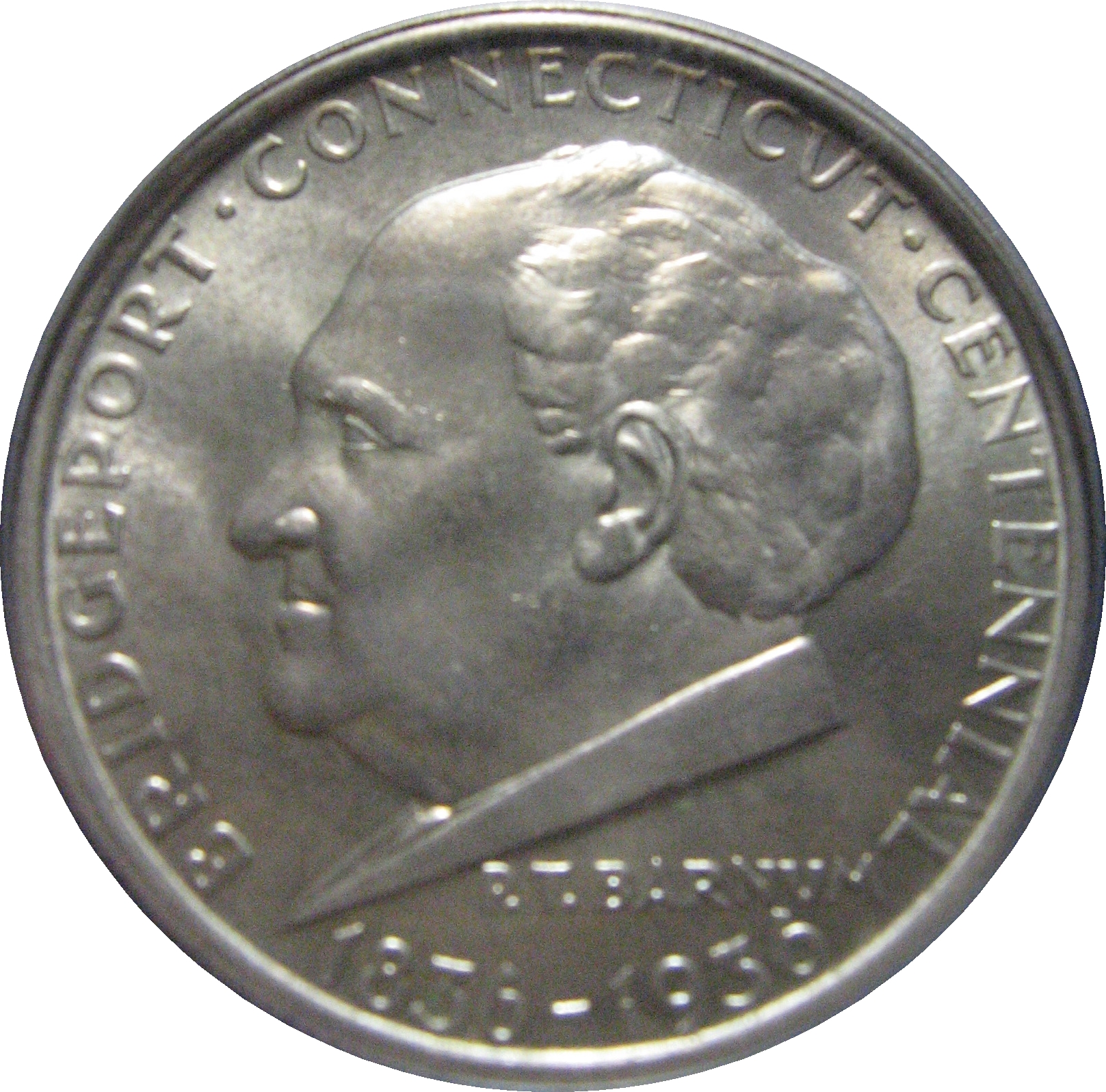
 Obverse of the Bridgeport Half Dollar
For further information, see People of Bridgeport, Connecticut
Perhaps Bridgeport's most famous resident from the past is P. T. Barnum, the circus promoter who also served as mayor of the city. His portrait was used on the obverse of the coin commemorating the city's centennial in 1936.
Other Bridgeporters who achieved fame far outside the city include:
- Actors: Robert Mitchum, Brian Dennehy, Bob Crane, and John Ratzenberger, actor/comedian Kevin Nealon and the actor and comedian Richard Belzer who once worked as a reporter for The Connecticut Post, Michael Jai White.
- Cartoonists: Al Capp, who created Li'l Abner, and Walt Kelly, who created Pogo, attended Bridgeport High Schools in the 1920s.
- Entertainers: P.T. Barnum, General Tom Thumb.
- Industrialists: Harvey Hubbell, Edwin H. Land, Nathaniel Wheeler.
- Military: David Hawley, naval commander and privateer during the American Revolution. Henry A. Mucci, who led the raid that rescued survivors of the Bataan Death March in World War II.
- Musicians: The Metropolitan Opera star Mimi Benzell. The pianist Samuel Sanford and composers Joseph Celli and Jin Hi Kim. Before relocating to Fairfield, Grammy Award winner John Mayer grew up in Bridgeport. Antonio Pappano, Syesha Mercado, and singer Jessica Delfino are also all from Bridgeport as well as Vinnie Vincent. Fanny Crosby, composer of more than 8,000 Christian hymns, lived here for the last fifteen years of her life, and is buried in the Mountain Grove Cemetery.
- Politicians: Jasper McLevy, who was the first socialist mayor of a city in New England.
- Religious: Neal Chase, a leader of a small Bahá'í sect, the Baha'is Under the Provisions of the Covenant was born here. Edward Egan, the former Roman Catholic bishop of Bridgeport, later became the cardinal archbishop of New York.
- Sportsmen: NBA players Charles Smith, John Bagley and Chris Smith and baseball players George "Kiddo" Davis, and Jim O'Rourke, the first player to be credited with a hit in a professional baseball game as well as Rob Dibble, Charles Nagy, and Ed Wojna, and lacrosse player Victor Ross.
See also
- History of Bridgeport, Connecticut
- National Register of Historic Places listings in Bridgeport, Connecticut
- List of people from Bridgeport, Connecticut
Notes
- ^ a b c "Race, Hispanic or Latino, Age, and Housing Occupancy: 2010 Census Redistricting Data (Public Law 94-171) Summary File (QT-PL), Bridgeport city, Connecticut". U.S. Census Bureau, American FactFinder 2. http://factfinder2.census.gov. Retrieved August 5, 2011.
- ^ http://pe.usps.com/search/jsp/search/vv_docread.jsp?k2dockey=http%3A%2F%2Fpe.usps.com%2Ftext%2Fdmm300%2FL007.htm%40PE_DMM300_HTML_5&serverSpec=56.0.145.56:9920&QueryParser=Simple&querytext=%28bridgeport%3Cand%3Ect%29&dtype=2#hit0
- ^ Waldo, v1 1917, pp. 14—16.
- ^ a b "Bridgeport, Conn.". The Encyclopedia Americana: a library of universal knowledge. 4. New York: Encyclopedia Americana Corp.. 1918. pp. 527. http://books.google.com/books?id=CGIMAAAAYAAJ&pg=PA527. Retrieved July 29, 2010.
- ^ Orcutt, v1 1886, p. 609.
- ^ Orcutt, v1 1886, pp. 470—474.
- ^ Waldo, v1 1917, pp. 37—38.
- ^ "History Of Frisbies". http://bridgeport.ct.schoolwebpages.com/education/components/scrapbook/default.php?sectiondetailid=26565. Retrieved November 28, 2007.
- ^ Emily Ross, Angus Holland (2005). One hundred great businesses and the minds behind them. Sourcebooks, Inc.. pp. 388. ISBN 978-1402206313. http://books.google.com/?id=6qSx2UrQ_H0C&pg=PA388.
- ^ Orcutt, v1 1886, pp. 608—609.
- ^ Waldo, v1 1917, pp. 222—225.
- ^ Strother, French (January 1916). "America, A New World Arsenal". The World's Work: A History of Our Time XXXI: 321–333. http://books.google.com/?id=09_Sr9emceQC&pg=PA321. Retrieved August 4, 2009.
- ^ "National Historic Places Nomination" (pdf). Black Rock. 1978. pp. 11. http://pdfhost.focus.nps.gov/docs/NRHP/Text/79002658.pdf. Retrieved July 28, 2010.
- ^ Burr, Raymond F., Abraham Lincoln: Western Star Over Connecticut, Lithographics Inc., Canton, Connecticut (no year given), pages 1 and 15; book contents reprinted by permission of the Lincoln Herald, (Harrogate, Tennessee) Summer, Fall and Winter, 1983 and Spring and Summer, 1984
- ^ Holzer, Harold, Lincoln at Cooper Union, (Simon & Schuster: New York), 2004 Chapter 8: "Unable to Escape This Toil," p. 201 ISBN 0-7432-2466-3
- ^ "Martin Luther King in Bridgeport?". Bridgeport Public Library. http://www.hiddenhistoryofbridgeport.com/2009/01/martin-luther-king-in-bridgeport.html. Retrieved July 30, 2010.
- ^ Fred Lucas (April 6, 2006). "Bush visits Bridgeport". News Times (Danbury). http://www.newstimes.com/default/article/Bush-visits-Bridgeport-98971.php. Retrieved July 30, 2010.
- ^ Kimes, Beverly Rae (editor) and Clark, Henry Austin, jr., The Standard Catalogue of American Cars 1805–1942, 2nd edition, Krause Publications (1989), ISBN 0-87341-111-0
- ^ Philip Sheldon Foner (1982). History of the Labor Movement in the United States: 1915–1916, on the Eve of America's Entrance into World War I, Vol. 6. International Publishers Company, Incorporated. p. 196. ISBN 9780717805952. http://books.google.com/?id=ixcYmW_jR8kC&pg=196&lpg=196&q. "[A] ten-hour center like Bridgeport was converted overnight into an eight-hour community, a result that ten years of agitation under normal conditions might not have accomplished."
- ^ "Bridgeport Working: Voices from the 20th Century". Bridgeport Public Library. http://www.bridgeporthistory.org/. Retrieved July 28, 2010.
- ^ Matthew L. Wald (September 5, 1982). "THE Workplace in Transition". New York Times (US). http://www.nytimes.com/1982/09/05/nyregion/the-workplace-in-transition.html. Retrieved July 28, 2010.
- ^ Andi Rierden (February 25, 1990). "Bridgeport is Fighting Its 'Dump City' Image". New York Times. http://www.nytimes.com/1990/02/25/nyregion/bridgeport-is-fighting-its-dump-city-image.html?pagewanted=1. Retrieved August 1, 2010.
- ^ Musante, Fred (February 1, 1998). "Teachers' Strike Stirs Bitter Memories". The New York Times. http://query.nytimes.com/gst/fullpage.html?res=9505E4D6173AF932A35751C0A96E958260&sec=&spon=&pagewanted=print. Retrieved April 26, 2010.
- ^ George Judson (August 2, 1991). "U.S. Judge Blocks Bridgeport From Bankruptcy Court". New York Times. http://www.nytimes.com/1991/08/02/nyregion/us-judge-blocks-bridgeport-from-bankruptcy-court.html?scp=212&sq=&st=nyt&pagewanted=1. Retrieved July 17, 2010. "The case attracted national attention as Bridgeport portrayed itself as a city abandoned by industry, left to bear alone the poverty and social problems of Fairfield County that its suburbs turned their backs on."
- ^ Lisa Prevost (April 10, 2009). "Revival in Progress; Stay Tuned". New York Times. http://www.nytimes.com/2009/04/12/realestate/12zone.html?ref=commercial. Retrieved August 5, 2010.
- ^ Bill Cummings (August 31, 2009). "Bridgeport council approves development plan". News Times (Danbury). http://www.newstimes.com/news/article/Bridgeport-council-approves-development-plan-1127.php. Retrieved August 5, 2010.
- ^ Keila Torres (February 14, 2010). "Agencies partner for housing/medical complex in Bridgeport". News Times (Danbury). http://www.newstimes.com/local/article/Agencies-partner-for-housing-medical-complex-in-364841.php. Retrieved August 5, 2010.
- ^ http://www.bridgeportct.gov/fire/Pages/MissionStatement.aspx. Accessed March 10, 2011
- ^ http://www.firenews.org/runs.html. Accessed March 10, 2011
- ^ http://www.bridgeportct.gov/pages/NewsDetails.aspx?itemid=84. Accessed July 25, 2010
- ^ http://www.ctpost.com/local/article/Former-Bridgeport-hospital-converted-to-elderly-656719.php
- ^ Source: Bridgeport Animal Control
- ^ The Winter of 95–96: A Season of Extremes, National Climatic Data Center
- ^ "NCDC: U.S. Climate Normals". National Oceanic and Atmospheric Administration. http://cdo.ncdc.noaa.gov/climatenormals/clim20/ct/060806.pdf. Retrieved May 11, 2010.
- ^ Cedar Creek on by Google Maps
- ^ U.S. Census Bureau. Accessed January 23, 2008.
- ^ "American FactFinder". United States Census Bureau. http://factfinder.census.gov. Retrieved 2008-01-31.
- ^ http://www.businessinsider.com/most-unequal-cities-in-america-2010-9#1-bridgeport-conn-metro-area-26
- ^ Zumbrun, Joshua (November 30, 2009). "America's Most Unequal Cities". Forbes. http://www.forbes.com/2009/11/30/americas-most-unequal-cities-business-beltway-unequal-cities.html.
- ^ "Registration and Party Enrollment Statistics as of October 25, 2005" (PDF). Connecticut Secretary of State. Archived from the original on September 23, 2006. http://web.archive.org/web/20060923151511/http://www.sots.ct.gov/ElectionsServices/lists/2005OctRegEnrollStats.pdf. Retrieved October 2, 2006.
- ^ City of Bridgeport CAFR
- ^ http://www.schooldigger.com/go/CT/districtrank.aspx
- ^ Everton Bailey Jr. (June 18, 2010). "Hartford Mayor Eddie Perez convicted of corruption". Associated Press (Christian Science Monitor). http://www.csmonitor.com/From-the-news-wires/2010/0618/Hartford-Mayor-Eddie-Perez-convicted-of-corruption. Retrieved August 15, 2010. "Corruption investigations have brought down several prominent Connecticut politicians within the past decade.... Bridgeport Mayor Joseph Ganim was convicted of corruption in 2003, sentenced to nine years in prison and released to a halfway house in Hartford in January. Former Waterbury Mayor Philip Giordano is serving a 37-year prison sentence for sexually abusing two girls, crimes that came to light during a federal corruption investigation."
- ^ Michael J. Daly (June 15, 2008). "Fabrizi's story still intrigues". Connecticut Post. http://www.ctpost.com/news/article/Fabrizi-s-story-still-intrigues-219989.php. Retrieved August 15, 2010.
- ^ a b Patricia Harris and David Lyon (February 6, 2008). "On a comeback: After some down times, city find itself on the verge of a renaissance". Boston Globe. http://www.boston.com/travel/explorene/connecticut/articles/2008/02/06/on_a_comeback/. Retrieved August 5, 2010.
- ^ Waldo, v1 1917, p. 277.
- ^ Jeff Holtz (August 18, 2002). "The View From/Bridgeport; Historic Seaside Park Recaptures Its Appeal". New York Times. http://www.nytimes.com/2002/08/18/nyregion/the-view-from-bridgeport-historic-seaside-park-recaptures-its-appeal.html?scp=2&sq=historic%20seaside%20park%20recaptures%20its%20appeal&st=cse. Retrieved August 1, 2010.
- ^ Waldo, v1 1917, p. 280.
- ^ F.L. & J.C. Olmsted (1884). Beardsley Park: Landscape Architects' Preliminary Report. Privately Printed (Boston). pp. 4–7. http://books.google.com/?id=reoCAAAAYAAJ&printsec=frontcover&pg=PA4&q.
- ^ . JSTOR 2711156.
- ^ Stephen King (1978). Night shift. Doubleday. pp. 255–256. ISBN 978-0385129916. http://books.google.com/?id=YTDDiSUsD-EC&pg=PA255&q. "'P.S. 119, Bridgeport, Connecticut' .... 'Ed Hamner, Sr., was a compulsive gambler. He worked for a top-line advertising agency in New York and then moved to Bridgeport sort of on the run.'"
- ^ A. J. Sobczak, Janet Alice Long, and Frank Northen Magill (1998). Cyclopedia of Literary Characters, Volume 1. Salem Press. pp. 190. ISBN 978-0893564384. http://books.google.com/?id=IJMYAAAAIAAJ. "Joseph Wykowski. a recruit of Polish background from Bridgeport, Connecticut..."
- ^ http://www.songlyrics.com/reo-speedwagon/157-riverside-avenue-lyrics/
- ^ http://thinkexist.com/quotation/everywhere_outside_new_york_city_is_bridgeport/206038.html
- ^ http://www.ctpost.com/local/article/Family-Guy-takes-a-shot-at-Bridgeport-877936.php
- ^ http://blogs.courant.com/roger_catlin_tv_eye/2010/12/family-guy-vs-bridgeport.html
- ^ http://www.imdb.com/List?endings=on&&locations=Bridgeport,%20Connecticut,%20USA&&heading=18;with+locations+including;Bridgeport,%20Connecticut,%20USA
- ^ "History" section of the WICC web site accessed June 29, 2006
- ^ WPKN web site "About" page accessed June 29, 2006
- ^ Radio Stations in Bridgeport, Connecticut. : Radio-Locator
References
- Samuel Orcutt (1886). A History of the Old Town of Stratford and City of Bridgeport Connecticut, Volume 1. Fairfield County Historical Society. http://www.archive.org/stream/historyofoldtown01orcu#page/n5/mode/2up.
- Samuel Orcutt (1886). A History of the Old Town of Stratford and City of Bridgeport Connecticut, Volume 2. Fairfield County Historical Society. http://www.archive.org/stream/ahistoryoldtown01conngoog#page/n5/mode/2up.
- John Nolen (1916). Better City Planning For Bridgeport. Bridgeport: City Plan Commission. http://books.google.com/?id=s9sAAAAAYAAJ&printsec=frontcover.
- George Curtis Waldo (1917). History of Bridgeport and Vicinity, Volume 1. S. J. Clarke. ISBN 978-1144359278. http://www.archive.org/stream/historyofbridgep01wald#page/n7/mode/2up.
- George Curtis Waldo (1917). History of Bridgeport and Vicinity, Volume 2. S. J. Clarke. http://www.archive.org/stream/historyofbridgep02wald#page/n7/mode/2up.
- Mary K. Witkowski (2002). Bridgeport at Work. Arcadia Publishing. ISBN 978-0738511238. http://books.google.com/?id=REmTWXZ2WdMC&printsec=frontcover&q.
- Cecelia Bucki (2001). Bridgeport's socialist New Deal, 1915–36. University of Illinois Press. ISBN 978-0252026874. http://books.google.com/?id=5sqULah9Jj0C&printsec=frontcover&q.
External links
- City of Bridgeport official website
- Bridgeport Public Schools
- Bridgeport History Links
- Bridgeport Working: Voices from the 20th Century – Bridgeport Public Library
Municipalities and communities of Fairfield County, Connecticut Cities 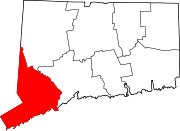
Towns Bethel | Brookfield | Darien | Easton | Fairfield | Greenwich | Monroe | New Canaan | New Fairfield | Newtown | Redding | Ridgefield | Sherman | Stratford | Trumbull | Weston | Westport | Wilton
Borough Other
communitiesAspetuck | Botsford | Black Rock | Branchville | Byram | Cannondale | Compo | Cos Cob | Cranbury | East Norwalk | Georgetown | Glenbrook | Glenville | Greenfield Hill | Greens Farms | Hattertown | Hawleyville | Huntington Center | Long Ridge | Lordship | Mianus | Old Greenwich | Riverside | Round Hill | Rowayton | Sandy Hook | Silvermine | South Norwalk | Southport | Stepney | Springdale
 State of Connecticut
Topics - Index
- Culture
- Constitution
- Delegations
- Elections
- Geography
- Government
- History
- Images
- People
- Visitor Attractions
Regions Counties Cities Places New England Topics Flag | Culture | Cuisine | Geography | Economy | Government | History | Population | Sports
States Major cities Boston | Bridgeport | Burlington | Cambridge | Hartford | Lowell | Manchester | New Haven | Portland | Providence | Quincy | Springfield | Stamford | Waterbury | Worcester
State capitals Augusta | Boston | Concord | Hartford | Montpelier | Providence
Transportation Rail MBTA (MA and RI) · Northeast Corridor (CT, MA, and RI) · Acela Express (CT, MA, and RI) · Downeaster (ME, NH, and MA) · Vermonter (CT, MA, and VT) · Shore Line East (CT) · Metro-North Railroad (CT and NY)Air Bradley International Airport (CT) · Portland International Jetport (ME) · Logan International Airport (MA) · Manchester-Boston Regional Airport (NH) · T. F. Green Airport (RI) · Burlington International Airport (VT)Mayors of cities with populations exceeding 100,000 in Connecticut - Bill Finch
(Bridgeport)
- Michael Pavia (R)
(Stamford)
 Other states: AL • AK • AZ • AR • CA • CO • CT • DE • FL • GA • HI • ID • IL • IN • IA • KS • KY • LA • ME • MD • MA • MI • MN • MS • MO • MT • NE • NV • NH • NJ • NM • NY • NC • ND • OH • OK • OR • PA • RI • SC • SD • TN • TX • UT • VT • VA • WA • WV • WI • WY
Largest cities of each state of the United States AL Birmingham AK Anchorage AZ Phoenix AR Little Rock CA Los Angeles CO Denver CT Bridgeport DE Wilmington FL Jacksonville GA Atlanta HI Honolulu ID Boise IL Chicago IN Indianapolis IA Des Moines KS Wichita KY Louisville LA New Orleans ME Portland MD Baltimore MA Boston MI Detroit MN Minneapolis MS Jackson MO Kansas City MT Billings NE Omaha NV Las Vegas NH Manchester NJ Newark NM Albuquerque NY New York City NC Charlotte ND Fargo OH Columbus OK Oklahoma City OR Portland PA Philadelphia RI Providence SC Columbia SD Sioux Falls TN Memphis TX Houston UT Salt Lake City VT Burlington VA Virginia Beach WA Seattle WV Charleston WI Milwaukee WY Cheyenne DC Washington
Territories:AS Pago Pago GU Hagåtña MP Saipan PR San Juan VI Charlotte Amalie 50 largest metropolitan statistical areas in the United States by population - New York
- Los Angeles
- Chicago
- Dallas–Fort Worth
- Philadelphia
- Houston
- Washington
- Miami
- Atlanta
- Boston
- San Francisco–Oakland
- Detroit
- Riverside–San Bernardino
- Phoenix
- Seattle
- Minneapolis–St. Paul
- San Diego
- St. Louis
- Tampa–St. Petersburg
- Baltimore
- Memphis
- Louisville
- Richmond
- Oklahoma City
- Hartford
- New Orleans
- Buffalo
- Raleigh
- Birmingham
- Salt Lake City
Categories:- Cities in Connecticut
- Bridgeport, Connecticut
- Populated places established in 1836
- Government units that have filed for Chapter 9 bankruptcy


Wikimedia Foundation. 2010.