- Millheim, Pennsylvania
-
Millheim, Pennsylvania — Borough — 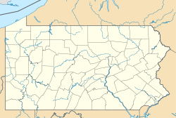
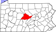
 Millheim, Pennsylvania
Coordinates: 40°53′28″N 77°28′33″W / 40.89111°N 77.47583°WCoordinates: 40°53′28″N 77°28′33″W / 40.89111°N 77.47583°W Country United States State Pennsylvania County Centre Settled 1797 Incorporated (borough) 1879 Area – Total 1.3 sq mi (3.4 km2) Elevation 696 ft (212 m) Population (2000) – Total 749 – Density 254.6/sq mi (98.1/km2) Time zone Eastern (EST) – Summer (DST) EDT (UTC) Zip code 16854 Area code(s) 814 Website Millheim Borough Website Millheim is a borough in Centre County, Pennsylvania, United States. It is part of the State College, Pennsylvania Metropolitan Statistical Area. The population was 749 at the 2000 census.
Contents
Geography
Millheim is located at 40°53′28″N 77°28′33″W / 40.89111°N 77.47583°W (40.890981, -77.475954)[1].
According to the United States Census Bureau, the borough has a total area of 1.3 square miles (3.4 km2), all of it land.
The town was named for having a millhouse situated along Elk Creek, the town still features the mill's raceway which flows through the downtown area.
Demographics
As of the census[2] of 2000, there were 749 people, 311 households, and 205 families residing in the borough. The population density was 572.6 people per square mile (220.8/km²). There were 333 housing units at an average density of 254.6 per square mile (98.1/km²). The racial makeup of the borough was 99.20% White, 0.13% African American, and 0.67% from two or more races.
There were 311 households out of which 28.9% had children under the age of 18 living with them, 53.1% were married couples living together, 8.7% had a female householder with no husband present, and 33.8% were non-families. 28.6% of all households were made up of individuals and 10.9% had someone living alone who was 65 years of age or older. The average household size was 2.41 and the average family size was 2.97.
In the borough the population was spread out with 24.4% under the age of 18, 6.4% from 18 to 24, 31.4% from 25 to 44, 21.9% from 45 to 64, and 15.9% who were 65 years of age or older. The median age was 38 years. For every 100 females there were 94.0 males. For every 100 females age 18 and over, there were 92.5 males.
The median income for a household in the borough was $37,000, and the median income for a family was $40,682. Males had a median income of $30,179 versus $20,104 for females. The per capita income for the borough was $19,511. About 10.4% of families and 11.9% of the population were below the poverty line, including 20.6% of those under age 18 and 5.8% of those age 65 or over.
External links
References
- ^ "US Gazetteer files: 2010, 2000, and 1990". United States Census Bureau. 2011-02-12. http://www.census.gov/geo/www/gazetteer/gazette.html. Retrieved 2011-04-23.
- ^ "American FactFinder". United States Census Bureau. http://factfinder.census.gov. Retrieved 2008-01-31.
Municipalities and communities of Centre County, Pennsylvania Boroughs Bellefonte | Centre Hall | Howard | Milesburg | Millheim | Philipsburg | Port Matilda | Snow Shoe | State College | Unionville
Townships CDPs Aaronsburg | Blanchard | Boalsburg | Clarence | Coburn | Eagleville | Houserville | Julian | Lemont | Madisonburg | Monument | North Philipsburg | Park Forest Village | Pine Glen | Pine Grove Mills | Pleasant Gap | Ramblewood | Rebersburg | Sandy Ridge | Spring Mills | Stormstown | Woodward | Zion
Unincorporated
communitiesColyer | Graysdale | Gum Stump | Ingleby | Peru | South Philipsburg | Struble | Tusseyville | University Park | Waddle
Categories:- Populated places established in 1797
- Boroughs in Centre County, Pennsylvania


Wikimedia Foundation. 2010.