- Coupeville, Washington
-
Coupeville, Washington
bah-TSAHD-ah-lee (Lower Skagit)— Town — Location of Coupeville, Washington
Coordinates: 48°13′6″N 122°41′1″W / 48.21833°N 122.68361°WCoordinates: 48°13′6″N 122°41′1″W / 48.21833°N 122.68361°W Country United States State Washington County Island Area - Total 1.3 sq mi (3.3 km2) - Land 1.3 sq mi (3.3 km2) - Water 0.0 sq mi (0.0 km2) Elevation 75 ft (23 m) Population (2010) - Total 1,831 - Density 1,346.7/sq mi (520.0/km2) Time zone Pacific (PST) (UTC-8) - Summer (DST) PDT (UTC-7) ZIP code 98239 Area code(s) 360 FIPS code 53-15185[1] GNIS feature ID 1512119[2] 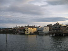 The waterfront of Coupeville
Coupeville is a town in Island County, Washington, United States. The population was 1,831 at the 2010 census. It is the county seat of Island County.[3]
Contents
History
Coupeville was founded in 1852 by Captain Thomas Coupe and is the second oldest town in the State of Washington. The town continues to preserve original pioneer homes with a variety of historic architectures including Queen Anne, Saltbox, and pioneer Block Houses. Coupe's original home, built in 1853, is one of the State's oldest. Coupeville's limits overlay Ebey's Landing National Historical Reserve established by Congress in 1980 as the first and one of the largest such reserves in the nation. Its 22 square miles (57 km2) encompass farmlands, Fort Ebey State Park, beaches, parks, trails and 91 nationally registered historic structures. Coupeville was officially incorporated on April 20, 1910.
Geography
Coupeville is located at 48°13′6″N 122°41′1″W / 48.21833°N 122.68361°W (48.218250, -122.683556).[4]
According to the United States Census Bureau, the town has a total area of 1.3 square miles (3.3 km²), all of it land.
Demographics
Historical populations Census Pop. %± 1910 310 — 1920 343 10.6% 1930 277 −19.2% 1940 325 17.3% 1950 379 16.6% 1960 740 95.3% 1970 678 −8.4% 1980 1,006 48.4% 1990 1,377 36.9% 2000 1,723 25.1% 2010 1,831 6.3% As of the census[1] of 2000, there were 1,723 people, 737 households, and 426 families residing in the town. The population density was 1,346.7 people per square mile (519.7/km²). There were 814 housing units at an average density of 636.2 per square mile (245.5/km²). The racial makeup of the town was 89.79% White, 1.57% African American, 0.52% Native American, 2.15% Asian, 2.84% from other races, and 3.13% from two or more races. Hispanic or Latino of any race were 5.34% of the population.
There were 737 households out of which 25.5% had children under the age of 18 living with them, 46.0% were married couples living together, 9.1% had a female householder with no husband present, and 42.1% were non-families. 36.9% of all households were made up of individuals and 19.4% had someone living alone who was 65 years of age or older. The average household size was 2.16 and the average family size was 2.81.
In the town the population was spread out with 21.1% under the age of 18, 6.0% from 18 to 24, 25.0% from 25 to 44, 22.7% from 45 to 64, and 25.2% who were 65 years of age or older. The median age was 43 years. For every 100 females there were 83.5 males. For every 100 females age 18 and over, there were 81.2 males.
The median income for a household in the town was $33,938, and the median income for a family was $47,721. Males had a median income of $33,235 versus $27,100 for females. The per capita income for the town was $18,720. About 8.9% of families and 11.4% of the population were below the poverty line, including 14.9% of those under age 18 and 8.2% of those age 65 or over.
References
- ^ a b "American FactFinder". United States Census Bureau. http://factfinder.census.gov. Retrieved 2008-01-31.
- ^ "US Board on Geographic Names". United States Geological Survey. 2007-10-25. http://geonames.usgs.gov. Retrieved 2008-01-31.
- ^ "Find a County". National Association of Counties. http://www.naco.org/Counties/Pages/FindACounty.aspx. Retrieved 2011-06-07.
- ^ "US Gazetteer files: 2010, 2000, and 1990". United States Census Bureau. 2011-02-12. http://www.census.gov/geo/www/gazetteer/gazette.html. Retrieved 2011-04-23.
External links
- History of Coupeville at HistoryLink
- Coupeville & Central Whidbey Island Chamber of Commerce
- Coupeville Visitors' Information
- Island County Historical Museum
- Sunnyside Cemetery - Coupeville's historic pioneer cemetery
- Historic Admiralty Head Lighthouse
- Coupeville Arts & Crafts Festival
- The Whidbey Examiner newspaper, based in Coupeville
Municipalities and communities of Island County, Washington County seat: Coupeville Cities 
Town Coupeville
CDPs Ault Field | Camano | Clinton | Freeland
Unincorporated
communitiesBaby Island Heights | Bayview | Keystone | Greenbank | Maxwelton | San de Fuca | Utsalady
Categories:- Populated places in Island County, Washington
- Towns in Washington (state)
- County seats in Washington (state)


Wikimedia Foundation. 2010.