- Maryland Route 257
-
Maryland Route 257
Rock Point Road 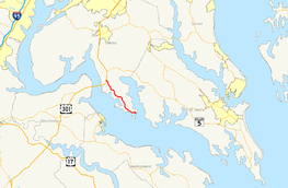
Map of Southern Maryland with MD 257 highlighted in redRoute information Maintained by MDSHA Length: 9.75 mi[1] (15.69 km) Major junctions South end:  MD 254 near Rock Point
North end:  US 301 in Newburg
Location Counties: Charles Highway system Maryland highway system
Interstate • US • State • Minor • Former • Turnpikes←  MD 256
MD 258  →
→Maryland Route 257 (MD 257) is a state highway in the U.S. state of Maryland. Known as Rock Point Road, the state highway runs 9.75 miles (15.69 km) from MD 254 near Rock Point north to U.S. Route 301 in Newburg. MD 257 serves the Cobb Neck of southern Charles County between the Potomac River and Wicomico River, connecting the communities of Cobb Island, Issue, Tompkinsville, and Wayside with US 301. The state highway was originally the southernmost section of MD 3, which was constructed on the peninsula in the 1910s. The portion of MD 3 south of US 301 was rebuilt and renumbered as MD 257 in the 1950s.
Contents
Route description
MD 257 begins at an intersection with the northern end of MD 254 (Cobb Island Road) near Rock Point. Rock Point Road continues southeast as a county highway to the namesake promontory at the confluence of the Wicomico River and Potomac River. MD 257 heads northwest as a two-lane road, passing through the hamlet of Issue, where Swan Point Road splits to the west toward the golf course-centered community of Swan Point. The state highway next passes through Tompkinsville, where the highway passes the southern end of Mount Victoria Road, which serves the village of Mount Victoria. MD 257 next passes through Wayside, where the highway crosses Piccowaxen Creek and intersects Morgantown Road, which leads to the Potomac River community of Morgantown. The state highway continues northwest to Newburg, where the highway meets the north end of Mount Victoria Road. MD 257 curves to the west and crosses over CSX's Pope's Creek Subdivision, whose southern terminus is at the nearby Morgantown Generating Station, before reaching a directional crossover intersection with US 301 (Robert Crain Highway) a short distance north of the Governor Harry W. Nice Memorial Bridge over the Potomac River.[1][2]
History
Rock Point Road was the southernmost segment of the highway from Rock Point to Waldorf that was marked for improvement by the Maryland State Roads Commission in 1909.[3] That highway was designated MD 3 in 1927.[4] The Cobb Neck portion of the state road was constructed as a 14-foot (4.3 m) gravel road between Wayside and Tompkinsville in 1913 and a 10-foot (3.0 m) concrete road from Tompkinsville to Rock Point in 1914.[5] The highway was completed when the state road north of Wayside was built as a gravel road by 1919.[6][7] MD 3 was widened and rebuilt with a bituminous concrete surface from Newburg to Tompkinsville in 1950 and from there to Rock Point in 1951.[8][9] MD 3 was renumbered as MD 257 in 1959.[10] MD 257 achieved its current length when the highway was rolled back from Rock Point to MD 254 around 1989.[11]
Junction list
The entire route is in Charles County.
Location Mile[1] Destinations Notes Rock Point 0.00 MD 254 south (Cobb Island Road) / Rock Point Road south – Cobb IslandSouthern terminus Wayside 7.47 Morgantown Road west – Morgantown Former MD 229 Newburg 9.75 US 301 (Robert Crain Highway) – Baltimore, RichmondNorthern terminus 1.000 mi = 1.609 km; 1.000 km = 0.621 mi References
- ^ a b c "Highway Location Reference: Charles County" (PDF). Maryland State Highway Administration. 2009. http://www.marylandroads.com/Location/2009_CHARLES.pdf. Retrieved 2011-01-11.
- ^ Google, Inc. Google Maps – Maryland Route 257 (Map). Cartography by Google, Inc. http://maps.google.com/maps?f=d&source=s_d&saddr=MD-257+W%2FRock+Point+Rd&daddr=MD-257+W%2FRock+Point+Rd&hl=en&geocode=FcYXSAIdLkNr-w%3BFUagSQIdbLtp-w&mra=ls&sll=38.379227,-76.955495&sspn=0.00386,0.009645&ie=UTF8&t=h&z=12. Retrieved 2011-01-11.
- ^ Maryland Geological Survey. Map of Maryland (Map) (1910 ed.).
- ^ Maryland Geological Survey. Map of Maryland: Showing State Road System and State Aid Roads (Map) (1927 ed.).
- ^ Report of the State Roads Commission of Maryland. 1912-1915. Baltimore: Maryland State Roads Commission. May 1915. pp. 50, 110. http://www.archive.org/details/annualreportsofs1912mary. Retrieved 2011-01-11.
- ^ Report of the State Roads Commission of Maryland. 1916-1919. Baltimore: Maryland State Roads Commission. January 1920. p. 32. http://www.archive.org/details/annualreportsofs1916mary. Retrieved 2011-01-11.
- ^ Maryland Geological Survey. Map of Maryland: Showing State Road System and State Aid Roads (Map) (1921 ed.).
- ^ Report of the State Roads Commission of Maryland. 1949-1950. Baltimore: Maryland State Roads Commission. 1950-12-20. pp. 152, 157. http://www.archive.org/details/reportofstateroa1949mary. Retrieved 2011-01-11.
- ^ Report of the State Roads Commission of Maryland. 1951-1952. Baltimore: Maryland State Roads Commission. 1952-12-15. p. 170. http://www.archive.org/details/reportofstateroa1951mary. Retrieved 2011-01-11.
- ^ Maryland State Roads Commission. Maryland: Official Highway Map (Map) (1959 ed.).
- ^ Maryland State Highway Administration. Maryland: Official Highway Map (Map) (1989 ed.).
External links
Roads in Charles County, Maryland State highways 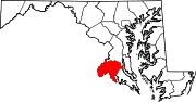
U.S. Highways Categories:- State highways in Maryland
- Roads in Charles County, Maryland


Wikimedia Foundation. 2010.