- Dorset and Somerset Canal
-
Dorset and Somerset Canal The north face of Murtry aqueduct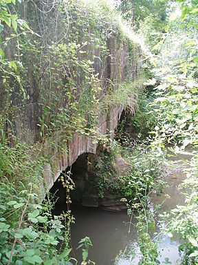
Date of act 1796 Date completed not completed Start point Nettlebridge End point Frome junction Locks 0 Status Abandoned, not completed Dorset and Somerset Canal plan Legend


Bristol Channel 
Bristol 
Bath 

Jn with Kennet and Avon Canal 

Coleford and Mells 


Nettlebridge basin and Frome Jn 
Wincanton Stalbridge Sturminster Newton Blandford Wareham branch 
Poole Harbour  Diagram showing the arrangement of Fussell's boat lift
The Dorset and Somerset Canal was a proposed canal in the south west of England. The main line was intended to link Poole, in Dorset with the Kennet and Avon Canal near Bradford on Avon, Wiltshire. A branch was to go from the main line at Frome to the southern reaches of the Somerset coalfield at Nettlebridge. Construction of the branch started in 1786, using boat lifts rather than locks to cope with changes of level, but the company ran out of money, and the canal was abandoned in 1803, never to be completed.
Contents
Proposals
Plans for a major canal to link Bristol and Poole, and therefore to make travel from the Bristol Channel to the English Channel easier and safer, were proposed in 1792. The suggested route passed through Wareham, Sturminster Newton, Wincanton and Frome, joining the River Avon at Bath. Collieries in the Mendips near Nettlebridge were to be served by a branch canal, while the main trade was seen as coal travelling southwards and clay travelling northwards. A public meeting was held in Wincanton in January 1793, at which a list of subscribers was started.[1]
There were several proposals as to the precise route, and so the canal engineer Robert Whitworth was asked to survey a route. By the time he reported back in September 1793, the route started from the Kennet and Avon Canal at Freshford near Limpley Stoke, rather than Bath, and having passed through Stalbridge, headed for Blandford rather than Wareham. The new route reflected the availability of water to supply the canal. Whitworth was busy and recommended that the projectors of the scheme should employ William Bennet of Frome as engineer. Bennet completed a detailed survey in 1795, estimating that the cost of the canal would be about £200,000, and the projectors approved most of his plan at a meeting in July. Short branches to Hamworthy and Wareham were added to the scheme, and the proposed junction with the Kennet and Avon Canal was later moved to Widford.[2]
By the time parliamentary approval was sought, the southern end had been cut back to Shillingstone, to reduce the cost, and an Act of Parliament was obtained on 24 March 1796, giving the company powers to raise £150,000, with an additional £75,000 if required. However, with the social changes and inflation that was occurring at the time, less than £80,000 was raised. With this, the company decided to start with the branch to Frome,[3] in order to capitalise on the lucrative markets in the coal fields and the clothing industry in Frome.
Construction
Dorset and Somerset Canal Legend

Nettlebridge basin 
Stratton Common 
Edford bridge 
Edford 
Coleford aqueduct Coleford 
unfinished tunnel at Goodeaves Farm Vobster 
Barrow Hill boat lift Five more lifts planned Murtry aqueduct 
Frome Jn (with main line) Construction began on the branch line, and about 8 miles (13 km) of canal was built, from Stratton Common towards Frome, passing through Coleford and Vobster.[4] The works included the three-arched Murtry Aqueduct over the Mells River near Hapsford,[5] a smaller aqueduct at Vallis Vale, near Coleford, and a tunnel at Goodeaves Farm, which was not completed.[4]
Both the main line and the branch involved significant changes in level, and the act had specified that conventional locks would be used on the main line, but that "caissons" would be used on the branch, which rose by 264 ft (80.5m) over its length. The idea of using vertical boat lifts was proposed by James Fussell,[6] owner of the nearby Mells ironworks, and his particular design was patented in 1798. It consisted of two tanks, joined by chains which passed over large wheels. Boats entered one or both of the caissons, which each had an extra chamber below the main caisson, and the chamber of the top caisson was filled with water to provide the extra weight needed to cause the lift to operate. Although different in detail to those later used successfully on the Grand Western Canal, it was essentially very similar.[7]
Fussell built the first boat lift at Barrow Hill. It was designed to take 10-ton boats, lifting them by 20 feet (6.1 m), and was tested during September and October 1800.[8] It was formally demonstrated on 13 October 1800,[9] and the Bath Chronicle carried a glowing report 3 days later.[10]
Five more lifts were to be built on the Barrow Hill section, and works started on the pits for four of them, but the company ran out of money in 1802, with 1.7 miles (2.7 km) of canal still to be excavated and the boat lifts unfinished. Having consulted an engineer called Underhill, the company obtained a second act of parliament in 1803, to allow them to raise more money and to build railways instead of the canal if this would reduce the cost, but they were unable to raise any more finance.[8] Construction ceased in 1803, and the canal was never completed.[11]
The canal today
Several features are still visible including a bridge that once carried the Edford to Stratton Common road over the canal[12] and an aqueduct at Coleford, with two semi-circular arches nearly 33 feet (10 m) across and a similar height.[13] The boat lift at Barrow Hill was the site of archaeological excavations in 2007.[14] The three-arched aqueduct over the River Mells at Murtry Bottom still have some 56 feet (17 m) of retaining wall attached to it.[5] A project to consider how best to conserve it has been aided by a grant from the Somerset Aggregates Levy Sustainability Fund.[15]
Point Coordinates
(Links to map resources)OS Grid Ref Notes Western end 51°14′13″N 2°28′52″W / 51.237°N 2.481°W ST665487 Edford Bridge 51°14′20″N 2°28′34″W / 51.239°N 2.476°W ST668489 Coleford Aqueduct 51°14′17″N 2°27′07″W / 51.238°N 2.452°W ST685488 Vobster Bridge 51°14′35″N 2°25′12″W / 51.243°N 2.420°W ST707494 Conduit Bridge 51°15′14″N 2°23′13″W / 51.254°N 2.387°W ST730506 Trial balance lock 51°14′56″N 2°22′23″W / 51.249°N 2.373°W ST740500 Murtry Aqueduct 51°14′49″N 2°20′31″W / 51.247°N 2.342°W ST762498 Whatcombe Wall 51°14′35″N 2°19′44″W / 51.243°N 2.329°W ST771494 See also
- Canals of Great Britain
- History of the British canal system
- James Fussell, canal promoter
Bibliography
- Atthill, Robin (1964). Old Mendip. Newton Abbott: David and Charles. ISBN 0715351710.
- Dunning, Robert (1983). A History of Somerset. Chichester: Phillimore & Co. ISBN 0-85033-461-6.
- Hadfield, Charles (1967). The Canals of South West England. David and Charles. ISBN 0-7153-4176-6.
- Toulson, Shirley (1984). The Mendip Hills: A Threatened Landscape. London: Victor Gollancz. ISBN 057503453X.
References
- ^ Hadfield 1967, pp. 91–92
- ^ Hadfield 1967, p. 92
- ^ Hadfield 1967, pp. 92–93
- ^ a b Hadfield 1967, p. 93
- ^ a b Details from listed building database (267107) . Images of England. English Heritage. Murtry Aqueduct
- ^ Atthill 1964
- ^ Hadfield 1967, pp. 93–94
- ^ a b Hadfield 1967, p. 94
- ^ Toulson 1984
- ^ Bath Chronicle, 16 October 1800, cited in Hadfield 1967, p. 94
- ^ Dunning 1983
- ^ Details from listed building database (267910) . Images of England. English Heritage. Old Canal Bridge, Edford Green
- ^ Details from listed building database (267856) . Images of England. English Heritage. Former Aqueduct at Grove, Coleford
- ^ Somerset Historic Environment Record
- ^ Details of Murtry Aqueduct
External links
Categories:- Canals in England
- Canals in Somerset
- History of Somerset


Wikimedia Foundation. 2010.