- M G Road, Bangalore
-
Coordinates: 12°58′26″N 77°36′43″E / 12.973801°N 77.611885°E
 M.G. Road.
 Bangalore CBD, M G Road is seen.
Mahatma Gandhi Road (Kannada: ಮಹಾತ್ಮಾ ಗಾಂಧಿ ರಸ್ತೆ) also known as M.G. Road is a road in Bangalore, India. It runs east from Trinity Circle at one end to Anil Kumble circle at the other. Known as South Parade earlier to pre-independence, it was renamed as Mahatma Gandhi Road on 26 February 1948.[1]
M. G. Road is also one of the busiest roads in the city and is lined on one side with retail stores, food outlets and restaurants. It has many office buildings, shops and theatres. It is also a home to a large number of buildings and banks.
Presently it is being improved and prepared for the long-awaited Metro Rail line that connects the eastern part of Bangalore with the west. The road has been made into a one way till October 2009. Commuters traveling towards MG Road from Anil Kumble Junction will have to turn towards Cubbon Road and go towards Manipal Centre, and further on to Trinity Junction, due to the construction of Metro Rail, according to the Bangalore traffic police. Traffic is generally slow with bottle-necks because of the ongoing work.
Many Indian cities have an MG road, and in general there is no linkage between these various roads (except that in many cases, these happen to be the busiest part of the city).[citation needed]
M.G. Road is adjacent to the Museum Road and perpendicular to Brigade Road. 123
Gallery
-

Bangalore MG road Utility Building
-

Barton centre
-

Bangalore Aerial view from MG road Utility Building
-
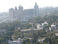
Bangalore Aerial view from MG road Utility Building
-
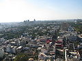
Bangalore Aerial view from MG road Utility Building
-
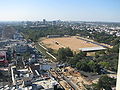
Bangalore Aerial view from MG road Utility Building
References
- ^ "Gandhi Road in Bangalore". Indian Express. 26 February 1948. http://news.google.com/newspapers?id=98U-AAAAIBAJ&sjid=nkwMAAAAIBAJ&pg=2307,4884968&dq=south+parade+bangalore&hl=en. Retrieved 13 December 2010.
Categories:- Roads in Bengaluru
- Shopping districts and streets in India
- Memorials to Mohandas Karamchand Gandhi
-


Wikimedia Foundation. 2010.