- Malabar (Northern Kerala)
-
For other uses, see Malabar (disambiguation).
Malabar
മലബാര്— region — Coordinates 12°01′N 75°17′E / 12.017°N 75.283°ECoordinates: 12°01′N 75°17′E / 12.017°N 75.283°E Country India State Kerala District(s) 6 (Kasaragod, Kannur, Kozhikode, Malappuram, Palakkad, Wayanad) Largest city Kozhikode Population
• Density
• 816 /km2 (2,113 /sq mi)
Literacy 91.74% Time zone IST (UTC+05:30) Area Codes-
• Vehicle • KL-09 to KL-14 and KL-49 to KL-60
Malabar (Northern Kerala) (Malayalam: മലബാര്, is an area of southern India lying between the Western Ghats and the Arabian Sea. The name is thought to be derived from the Malayalam word Mala (hill) and puram (region) derived or westernised into bar. This part of India was a part of the British East India Company-controlled Madras State, when it was designated as Malabar District. It included the northern half of the state of Kerala and some coastal regions of present day Karnataka. The area is predominantly Hindu but the majority of Kerala's Muslim population known as Mappila also live in this area, as well as a sizable ancient Christian population.[1] The name is sometimes extended to the entire south-western coast of the peninsula, called the Malabar Coast. Malabar is also used by ecologists to refer to the tropical and subtropical moist broad-leaf forests of south-western India (present day Kerala).
In ancient times, the term Malabar was used to denote the entire south-western coast of the Indian peninsula. But today, Malabar is only used for the former Malabar district, or northern districts of Kerala state.
Contents
Malabar region
The Malabar region lies along the south-west coast of the Indian peninsula and forms the northern part of present-day Kerala state. Malayalam is the chief language of the region, and the ancestors of today's population have inhabited the region for centuries. Tulu speakers can be found mainly in the northern Kasaragod District. The region formed part of the ancient kingdom of Chera until the early 12th century. Following the breakup of the Chera Kingdom, the chieftains of the region proclaimed their independence. Notable among these were the Kolathiris of North Malabar, Zamorins of Calicut, the Coylot Wanees Country of NorthEast and coastal Ceylon (including Puttalam) and the Valluvokonathiris of Walluvanad. The Zamorin of Calicut became the most powerful of the Kings in the region by the 13th century primarily due to flourishing international trade at Calicut and Beypore port. The region came under British rule in the 18th century, during the Anglo-Mysore Wars. During the British rules, the Malabar area was divided into two categories as North and South. North Malabar comprises : Present Kasaragod and Kannur Districts, Mananthavady Taluk of Wayanad District and Vadakara Taluk of Kozhikode District. Left over area in South Malabar.
At the conclusion of the Anglo-Mysore wars, the region was organized into a district of Madras Presidency. The British district included the present-day districts of Kannur, Kozhikode, Wayanad, Malappuram, much of Palakkad. The administrative headquarters was at Calicut (Kozhikode). With India's independence, Madras presidency became Madras State, which was divided along linguistic lines on 1 November 1956, whereupon Malabar district was merged with the Kasaragod district immediately to the north and the state of Travancore-Cochin to the south to form the state of Kerala.

Malabar Coast
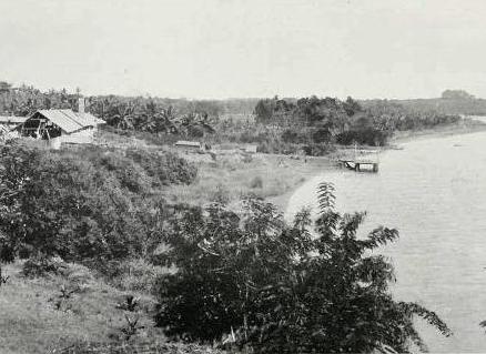
 Backwaters in the Malabar, c.a. 1913
The Malabar Coast, in historical contexts, refers to India's southwest coast, lying on the narrow coastal plain of Karnataka and Kerala states between the Western Ghats range and the Arabian Sea. The coast runs from south of Goa to Cape Comorin on India's southern tip.
The Malabar Coast is also sometimes used as an all encompassing term for the entire Indian coast from the western coast of Konkan to the tip of the subcontinent at Cape Comorin. It is over 525 miles or 845 km long. It spans from the South - Western coast of Maharashtra and goes along the coastal region of Goa, through the entire western coast of Karnataka and Kerala and reaches till Kanyakumari. It is flanked by the Arabian Sea on the west and the Western Ghats on the east. The Southern part of this narrow coast is the South Western Ghats moist deciduous forests.
The Malabar Coast features a number of historic port cities. Notable among these are the Muziris, Beypore and Thundi (near Kadalundi) during ancient times and Kozhikode (Calicut), Cochin, and Kannur in the medieval period and have served as centers of the Indian Ocean trade for centuries. Because of their orientation to the sea and to maritime commerce, the coastal cities of Malabar are very cosmopolitan and have hosted some of the first groups of Christians (now known as Syrian Malabar Nasranis), Anglo-Indians, Jews (today called as Cochin Jews), and Muslims (at present known as Mappilas) in India.
Geographically, the Malabar Coast, especially on its westward-facing mountain slopes, comprises the wettest region of southern India as the Western Ghats intercept the moisture-laden monsoon rains.
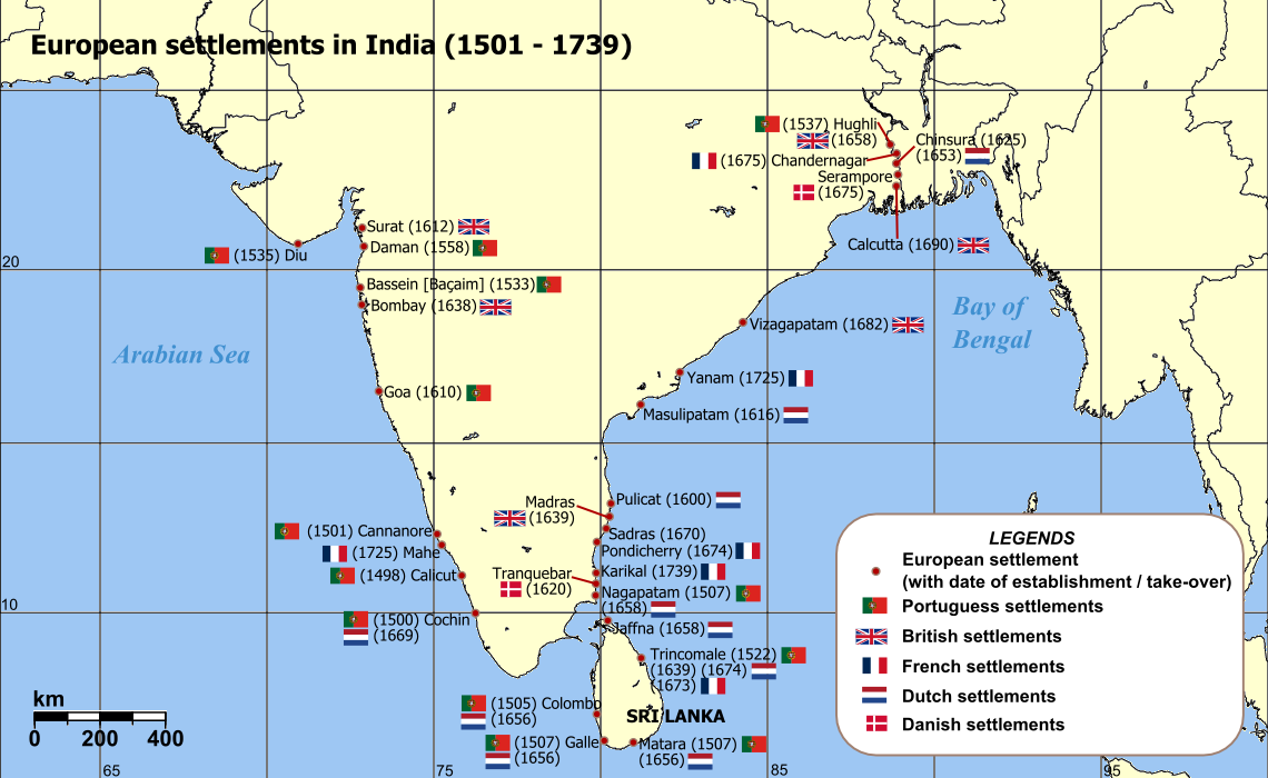
 European settlements in India
Malabar rainforests
The term Malabar rainforests refers to one or more distinct ecoregions recognized by biogeographers:
- the Malabar Coast moist forests formerly occupied the coastal zone to the 250 meter elevation (but 95% of these forests no longer exist)
- the South Western Ghats moist deciduous forests grow at intermediate elevations
- the South Western Ghats montane rain forests cover the areas above 1000 meters elevation
The Monsooned Malabar coffee bean comes from this area.
See also
References
- ^ "Kerala". Encyclopædia Britannica. 2008. Encyclopædia Britannica Online. 8 June 2008
 State of Kerala
Capital : Thiruvananthapuram Symbols Bird: Great Hornbill | Animal: Indian Elephant | Tree: Coconut | Flower: Golden Shower | Fish: Karimeen
Topics History | Economy | Geography | Demographics | Flora and Fauna | Government | Culture | Arts | Film | Tourism
Districts Thiruvananthapuram | Kollam | Pathanamthitta | Alappuzha | Kottayam | Idukki | Ernakulam | Thrissur | Palakkad | Malappuram | Kozhikode | Wayanad | Kannur | Kasaragod
Municipal Corporations Thiruvananthapuram | Kochi | Kozhikode | Kollam | Thrissur
Municipalities Adoor | Alappuzha | Aluva | Angamaly | Attingal | Chalakkudy | Changanacherry | Chavakkad | Chengannur | Cherthala | Chittur - Tattamangalam | Eloor | Guruvayoor | Irinjalakuda | Kalamassery | Kalpetta | Kanhangad | Kannur | Karunagapally | Kasaragod | Kayamkulam | Kodungallur | Koothuparamba | Kothamangalam | Kottakkal | Kottayam | Koyilandy | Kunnamkulam | Malappuram | Manjeri | Maradu | Mattannur | Mavelikkara | Muvattupuzha | Nedumangad | Neyyattinkara | Nilambur | Nileshwaram | North Paravoor | Ottappalam | Pala | Palakkad | Paravoor (South) | Pathanamthitta | Payyannur | Perinthalmanna | Perumbavoor | Ponnani | Punalur | Shoranur | Thalassery | Taliparamba | Thiruvalla | Thodupuzha | Thrikkakara | Thripunithura | Tirur | Vadakara | Vaikom | Varkala
Taluks Adoor | Alathoor | Aluva | Ambalappuzha | Changanasserry | Chavakkad | Chenganoor | Cherthala | Chittur | Chirayinkeezhu | Devikulam | Eranad | Hosdurg | Kanayannur | Kanjirappally | Kannur | Karthikappally | Karunagappalli | Kasaragod Kochi | Kodungallor | Kollam | Kothamangalam | Kottarakkara | Kottayam | Koyilandi | Kozhencherry | Kozhikode | Kunnathoor | Kunnathunad | Kuttanad | Mallappally | Mananthavadi | Mannarkkad | Mavelikkara | Meenachil | Mukundapuram | Muvattupuzha | Nedumangad | Neyyattinkara | Nilambur | Ottappalam | Palakkad | Paravur | Pathanapuram | Peermade | Ponnani | Ranni | Sulthan Batheri | Taliparamba | Thalappilli | Thalassery | Thiroorangadi | Thiruvalla | Thiruvananthapuram | Thodupuzha | Thrissur | Thirur | Udumbanchola | Vadakara | Vaikom | Valluvanad | Vythiri
Historical Regions North Malabar | South Malabar | Cochin | Northern Travancore | Central Travancore | Southern Travancore
Portal : Kerala North Malabar North Malabar Region Districts Main Towns and Cities Kannur · Thalassery · Vadakara · Kasaragod · Mahe · Koyilandy · Payyannur · Kanhangad · Neeleswaram · Thaliparamba · Kuthuparamba · Mattannur · Mananthavady · Perambra · Kuttiyadi · Peringome · Nadapuram · Payyoli · Iritty · Azhiyur · Orkkateri · Meppayur · Vellikulangara · Edakkad · New Mahe · Pinarayi · Mambaram · Panoor · Vellamunda · Thirunelli · Edavaka · Thavinjal · Panamaram · Irikkur · Kottayam · Anjarakkandy · Pazhayangadi · Trikarpur · Manjeswaram · Pappinisseri · Kalliasseri · Cherukunnu · Kannapuram · Morazha · Aroli · Pattuvam · Sreekandapuram · Alakode · Cherupuzha · Muzhappilangad · Azhikode · Cheruvathur · MattoolVelliyamkallu: Associated with the valiant Kunhali Marakkar at Vadakara · Sand Banks: Where the Kotakal river reaches the sea at Vadakara · Silent Beach: South of Sand Banks is Silent Beach at Vadakara · Azhiyoor Vadakara · Palloor Mahé · Panthakkal Mahé · Poozhithala Mahé · Mahe Beach Mahé · Mayyazhi Puzhayoram Mahé · Pakshi Pathalam Thirunelli Mananthavady · Pookkottu Thadakam (Lake) Mananthavady · Tellichery Fort Thalassery · Muzhappilangadu Drive-in Beach on Thalassery - Kannur Road · Payyambalam Beach Kannur · St. Angelo Fort Kannur · Meenkunnu Beach Kannur · Valapattanam Kannur · Pazhassi Dam Kannur · The thuruths (small islands in the river) of Cherukunnu · The small hills of Cherukunnu · Azheekkal ferry and beach Azhikode · Ezhimala beach Payyannur · Kotti Payyannur · Ayyankunnu Iritty · Paithal Mala Thaliparamba · Snake Park Parassinikkadavu · Vismaya, the water theme park Parassinikkadavu · Valiyaparamba island Trikaripur · Ranipuram Kanhangad · Bekal Fort Kasaragod · Chandragiri Fort Kasaragod · Ananthapuram Lake Kasaragod · Kanwatheertha Beach Resort Kasaragod ·
Categories:- Regions of India
- Regions of Karnataka
- Regions of Kerala
-

Wikimedia Foundation. 2010.