- Maryland Route 806
-
Maryland Route 806
Route information Maintained by MDSHA Length: 4.05 mi[1] (6.52 km)
2 sectionsMajor junctions South end:  US 15 near Catoctin Furnace
 MD 550 in Thurmont
North end: Roddy Creek Road near Thurmont Location Counties: Frederick Highway system Maryland highway system
Interstate • US • State • Minor • Former • Turnpikes←  MD 802
MD 807  →
→Maryland Route 806 (MD 806) is a state highway in the U.S. state of Maryland. The state highway runs a total of 4.05 miles (6.52 km) in two segments from U.S. Route 15 (US 15) near Catoctin Furnace north to Roddy Creek Road near Thurmont. MD 806A, which has a length of 3.04 miles (4.89 km) from Catoctin Furnace to Thurmont, and MD 806R, which extends 1.01 miles (1.63 km) on the north side of Thurmont, are separated by a section of municipally-maintained road on the south side of Thurmont and a segment of MD 550 north of MD 77. MD 806 is the old alignment of US 15 through Catoctin Furnace and Thurmont. The state highway was originally constructed in the 1910s. MD 806 was assigned to the highway when US 15 bypassed Thurmont in the late 1950s. The state highway became a split route in the late 1980s. There have been several other segments of MD 806 along former sections of US 15 in Frederick County, including portions around Lewistown and south of Frederick.
Contents
Route description
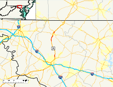
MD 806 begins at an intersection with US 15 (Catoctin Mountain Highway) and Auburn Road, the old alignment of US 15 that heads south closely paralleling the southbound lanes of US 15. The state highway, officially MD 806A, heads north as two-lane Catoctin Furnace Road through the community of Catoctin Furnace. MD 806 parallels the northbound lanes of US 15, which itself parallels the eastern edge of Catoctin Mountain and the eastern boundary of Cunningham Falls State Park. The state highway crosses Little Hunting Creek and passes the site of the Catoctin Furnace and the Catoctin Wildlife Preserve and Zoo. Just south of the zoo, MD 806 has access to US 15 and the Manor Area of Cunningham Falls State Park via a two-way spur to US 15, which closely parallels MD 806 at that point. The state highway veers away from US 15 and intersects Blue Mountain Road, which heads west as unsigned US 15G to provide another access point to the parallel divided highway. MD 806 traverses High Run then reaches its northern terminus at the southern town limit of Thurmont.[1][2]
The roadway, which was formerly part of MD 806, continues north as municipally-maintained Frederick Road through a commercial area. Frederick Road intersects Thurmont Boulevard, which heads west to a diamond interchange with US 15. The old highway crosses Hunting Creek and turns north onto Water Street to pass through downtown Thurmont. At MD 77 (Main Street), the old alignment becomes a state highway again as part of MD 550, which heads east with MD 77 along Main Street and north along Church Street, which passes under the Maryland Midland Railway. The Church Street portion of MD 550 is also signed as MD 806. The next official segment of MD 806 (officially MD 806R) begins at MD 550 and follows Emmitsburg Road northeast out of the town of Thurmont. As MD 806 approaches US 15, the road makes a right angle turn to the east and its name changes to Albert Staub Road. The state highway makes a sharp turn to the northeast and crosses Owens Creek to its northern terminus at Roddy Creek Road. Roddy Creek Road heads east toward the Roddy Road Covered Bridge and west to an intersection with US 15.[1][3]
History
The two sections of MD 806 through Catoctin Furnace and Thurmont and the intervening town streets are the old alignment of US 15. Originally part of the Frederick and Emmitsburg Turnpike, the highway was one of the original state roads marked for improvement by the Maryland State Roads Commission in 1909.[4][5] The commission purchased the turnpike in 1911 and resurfaced the turnpike south of Thurmont with a 14-foot (4.3 m) wide macadam surface in 1915.[6][7] The same type of surface was applied along the turnpike right-of-way from Thurmont to Emmitsburg between 1915 and 1919.[7][8] The highways through Catoctin Furnace and Thurmont were designated US 15 in 1927 and widened to 20 feet (6.1 m) around 1930.[9][10]
Construction on the Thurmont Bypass from Catoctin Furnace to Owens Creek began in 1956.[11] The new highway, which was constructed as the first roadway of an ultimate divided highway, was completed in 1958.[11][12] US 15 moved to its present alignment and the old road was designated as the first section of MD 806.[13] The northern terminus of the Thurmont section of MD 806 was originally just north of the right angle turn from Emmitsburg Road to Albert Staub Road, where MD 806 met then two-lane US 15 at an oblique intersection.[14] When US 15 was reconstructed as a divided highway from MD 550 north toward Emmitsburg in 1983, MD 806's original terminus was removed.[15] MD 806 was moved onto Albert Staub Road, which was extended north over a new bridge over Owens Creek to its present terminus.[16][17] MD 806 was split into MD 806A and MD 806R when the highway from the southern town limit of Thurmont to MD 77 was transferred to municipal maintenance around 1989.[18]
Several other sections of the old alignment of US 15 have been marked as sections of MD 806. US 15 bypassed Lewistown in 1962.[19] The old alignment along Hessong Bridge Road and Angleberger Road was a segment of MD 806 until it was transferred to county maintenance around 1985.[20] US 15 originally followed what is now MD 85 from Tuscarora to Frederick. When US 15 was moved to Washington National Pike (now Interstate 270) and the Frederick Freeway after the latter freeway was completed in 1959, the portion of US 15 between Washington National Pike and MD 355 became a segment of MD 806.[21][22] The segment of MD 806 south of Frederick became part of MD 85 in 1971.[23] Other portions of the old alignment of US 15 that were part of MD 806 include Hansonville Road between Frederick and Lewistown; Auburn Road between Lewistown and Catoctin Furnace; and Franklinville Road, St. Anthony Road, and Old Emmitsburg Road between Thurmont and Emmitsburg.
Junction list
The entire route is in Frederick County.
Location Mile
[1]Destinations Notes Catoctin Furnace 0.00 US 15 (Catoctin Mountain Highway) / Auburn Road south – Frederick, GettysburgSouthern terminus of MD 806A 1.29 To US 15Two-way spur to US 15 2.31 Blue Mountain Road to US 15Blue Mountain Road west is unsigned US 15G Thurmont 3.04 Frederick Road north Northern terminus of MD 806A; Thurmont town limit Former MD 806 continues as municipally-maintained Frederick Road and Water Street toward MD 77 and MD 550 0.00  MD 550 (Church Street) to MD 77 – Sabillasville
Southern terminus of MD 806R 1.01 Roddy Creek Road to US 15Northern terminus of MD 806R 1.000 mi = 1.609 km; 1.000 km = 0.621 mi Auxiliary routes
MD 806 has three existing unsigned auxiliary routes.
- MD 806I is the designation for the unnamed 0.53-mile (0.85 km) service road that runs north along the southbound side of US 15 from an intersection with US 15 past Willow Road to a dead end north of Frederick.[1]
- MD 806N is the designation for the unnamed 0.09-mile (0.14 km) service road that runs north along the southbound side of US 15 from Hayward Road north to an intersection with US 15. The route originally ran to a cul-de-sac until it was realigned to end at US 15 in 2010.[24]
- MD 806O is the designation for the unnamed 0.04-mile (0.064 km) service road that runs north along the southbound side of US 15 from Lohr Road to a dead end between Thurmont and Emmitsburg.[1][25]
References
- ^ a b c d e f "Highway Location Reference: Frederick County" (PDF). Maryland State Highway Administration. 2009. http://www.marylandroads.com/Location/2009_FREDERICK.pdf. Retrieved 2011-03-22.
- ^ Google, Inc. Google Maps – Maryland Route 806A (Map). Cartography by Google, Inc. http://maps.google.com/maps?f=d&source=s_d&saddr=Catoctin+Furnace+Rd&daddr=Catoctin+Furnace+Rd+to:Catoctin+Furnace+Rd&hl=en&geocode=FSvQWwIdF3li-w%3BFe36WwId6HNi-w%3BFV1uXAId4Kxi-w&mra=ls&sll=39.588956,-77.428079&sspn=0.013791,0.038581&ie=UTF8&t=h&z=13. Retrieved 2011-03-22.
- ^ Google, Inc. Google Maps – Maryland Route 806R (Map). Cartography by Google, Inc. http://maps.google.com/maps?f=d&source=s_d&saddr=Emmitsburg+Rd&daddr=Albert+Staub+Rd&hl=en&geocode=FcivXAIdGs9i-w%3BFZ_cXAIdNvRi-w&mra=ls&sll=39.63448,-77.40578&sspn=0.013782,0.038581&ie=UTF8&t=h&z=15. Retrieved 2011-03-22.
- ^ Clark, William Bullock (1899). Report on the Highways of Maryland. Baltimore: Maryland Geological Survey. p. 232. http://books.google.com/books?id=b9l9AAAAIAAJ&printsec=frontcover#v=onepage&q&f=false. Retrieved 2011-03-22.
- ^ Maryland Geological Survey. Map of Maryland (Map) (1910 ed.).
- ^ Report of the State Roads Commission of Maryland. 1908-1911. Baltimore: Maryland State Roads Commission. May 1912. p. 36. http://www.archive.org/details/annualreportsofs1908mary. Retrieved 2011-03-22.
- ^ a b Report of the State Roads Commission of Maryland. 1912-1915. Baltimore: Maryland State Roads Commission. May 1915. pp. 50, 110. http://www.archive.org/details/annualreportsofs1912mary. Retrieved 2011-03-22.
- ^ Report of the State Roads Commission of Maryland. 1916-1919. Baltimore: Maryland State Roads Commission. January 1920. p. 22. http://www.archive.org/details/annualreportsofs1916mary. Retrieved 2011-03-22.
- ^ Maryland Geological Survey. Map of Maryland: Showing State Road System and State Aid Roads (Map) (1927 ed.).
- ^ Report of the State Roads Commission of Maryland. 1927-1930. Baltimore: Maryland State Roads Commission. 1930-10-01. pp. 82–83. http://www.archive.org/details/reportofstateroa1927mary. Retrieved 2011-03-22.
- ^ a b Report of the State Roads Commission of Maryland. 1955-1956. Baltimore: Maryland State Roads Commission. 1956-11-02. pp. 203, 205. http://www.archive.org/details/reportofstateroa1955mary. Retrieved 2011-03-22.
- ^ Maryland State Roads Commission. Maryland: Official Highway Map (Map) (1958 ed.).
- ^ Maryland State Roads Commission. Maryland: Official Highway Map (Map) (1960 ed.).
- ^ United States Geological Survey (1981-07-01). 2 km NE of Thurmont, Maryland, United States (Map). Topo Map. http://msrmaps.com/image.aspx?T=2&S=11&Z=18&X=734&Y=10976&W=2&qs=. Retrieved 2011-03-22.
- ^ Maryland State Highway Administration. Maryland: Official Highway Map (Map) (1983-84 ed.).
- ^ "NBI Structure Number: 100000100173010". National Bridge Inventory. http://nationalbridges.com/nbi_record.php?StateCode=24&struct=100000100173010. Retrieved 2011-03-22.
- ^ United States Geological Survey (1988-04-05). 2 km NE of Thurmont, Maryland, United States (Map). Topo Map. http://msrmaps.com/image.aspx?T=1&S=11&Z=18&X=734&Y=10976&W=2&qs=. Retrieved 2011-03-22.
- ^ Maryland State Highway Administration. Maryland: Official Highway Map (Map) (1989 ed.).
- ^ Maryland State Roads Commission. Maryland: Official Highway Map (Map) (1962 ed.).
- ^ Maryland State Highway Administration. Maryland: Official Highway Map (Map) (1985-86 ed.).
- ^ Maryland State Roads Commission. Maryland: Official Highway Map (Map) (1959 ed.).
- ^ Maryland State Roads Commission. Maryland: Official Highway Map (Map) (1964 ed.).
- ^ Maryland State Roads Commission. Maryland: Official Highway Map (Map) (1971 ed.).
- ^ "Highway Location Reference: Frederick County" (PDF). Maryland State Highway Administration. 2010. http://www.roads.maryland.gov/Location/2010_Frederick.pdf. Retrieved 2011-07-02.
- ^ Google, Inc. Google Maps – Maryland Route 806O (Map). Cartography by Google, Inc. http://maps.google.com/maps?f=d&source=s_d&saddr=Lohr+Rd&daddr=Lohr+Rd&hl=en&geocode=FfYsXQIdaFxj-w%3BFS0uXQIdll5j-w&mra=ls&sll=39.660396,-77.372053&sspn=0.003733,0.009645&ie=UTF8&ll=39.661238,-77.374515&spn=0.001867,0.004823&t=h&z=18. Retrieved 2011-03-22.
External links
Roads in Frederick County, Maryland State highways 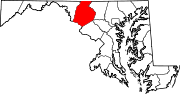
U.S. Highways Interstate Highways Categories:- State highways in Maryland
- Roads in Frederick County, Maryland


Wikimedia Foundation. 2010.