- Morval, Cornwall
-
Not to be confused with Morval.
Coordinates: 50°23′02″N 4°26′53″W / 50.384°N 4.448°W
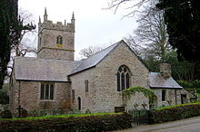 Morval parish church
Morval (Cornish: Morval) is a rural civil parish and hamlet in south Cornwall, United Kingdom. The hamlet is approximately two miles (3 km) north of Looe and five miles (8 km) south of Liskeard[1].
Morval parish is in the Liskeard Registration District and the population in the 2001 census was 616. The meaning of the name Morval is unknown. To the north, the parish is bounded by Dobwalls and Trewidland and Menheniot parishes, to the east by St Germans, to the south by St Martin-by-Looe, and to the west by Duloe[2].
A hundred metres south of the church is Morval House (aerial view), a large Tudor residence which was once the home of the Glynn, Buller and Kitson families. The house was altered in the 18th century and according to Nikolaus Pevsner is "one of the best in Cornwall".[3]
Parish church
The 13th century parish church is dedicated to St Wenna and is situated in a secluded location at OS Grid Ref SX260567 in Morval hamlet. The church was probably built in the 13th century with transepts and a north aisle was added in the 15th century. The west tower is built of slate[2]. There is a monument to Walter (William?) Coode (d. 1637) and his family and two early pieces of communion plate (a paten of 1528-29 and a chalice of ca. 1576; the paten which is plain is the only pre-Reformation plate in Cornwall).[4]
References
External links
 Media related to Morval, Cornwall at Wikimedia Commons
Geography of Cornwall Unitary authorities Major settlements Bodmin • Bude • Callington • Camborne • Camelford • Falmouth • Fowey • Hayle • Helston • Launceston • Liskeard • Looe • Lostwithiel • Marazion • Newlyn • Newquay • Padstow • Par • Penryn • Penzance • Porthleven • Redruth • Saltash • St Austell • St Blazey • St Columb Major • St Ives • St Just-in-Penwith • St Mawes • Stratton • Torpoint • Truro • Wadebridge
See also: Civil parishes in CornwallRivers Topics History • Status debate • Flag • Culture • Places • People • The Duchy • Diocese • Politics • Hundreds/shires • Places of interest • full list...Civil parishes of South East Cornwall constituency  Antony • Boconnoc • Botusfleming • Broadoak • Callington • Calstock • Deviock • Dobwalls and Trewidland • Duloe • Landrake with St Erney • Lanreath • Lansallos • Landulph • Lanlivery • Lanteglos • Linkinhorne • Liskeard • Looe • Lostwithiel • Luxulyan • Maker-with-Rame • Menheniot • Millbrook • Morval • Pelynt • Pillaton • Quethiock • Saltash • Sheviock • South Hill • St Cleer • St Dominick • St Germans • St Ive • St John • St Keyne • St Martin-by-Looe • St Mellion • St Neot • St Pinnock • St Veep • St Winnow • Torpoint • WarlegganCategories:
- Civil parishes in Cornwall
- Villages in Cornwall
- Cornwall geography stubs

Wikimedia Foundation. 2010.