- National Register of Historic Places listings in Canadian County, Oklahoma
-
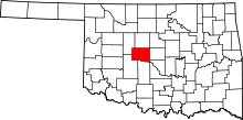 Location of Canadian County in Oklahoma
This is a list of the National Register of Historic Places listings in Canadian County, Oklahoma.
This is intended to be a complete list of the properties and districts on the National Register of Historic Places in Canadian County, Oklahoma, United States. The locations of National Register properties and districts for which the latitude and longitude coordinates are included below, may be seen in a Google map.[1]
There are 23 properties and districts listed on the National Register in the county.
-
- This National Park Service list is complete through NPS recent listings posted November 10, 2011.[2]
Current listings
[3] Landmark name [4] Image Date listed Location City or town Summary 1 Avant's Cities Service Station March 2, 2004 220 S. Choctaw
35°31′53″N 97°57′17″W / 35.531389°N 97.954722°WEl Reno 2 Bridgeport Hill Service Station December 5, 2003 Junction of Old U.S. Route 66 and a spur of U.S. Route 281
36°03′18″N 95°47′28″W / 36.055°N 95.791111°WGeary 3 Bridgeport Hill-Hydro OK 66 Segment March 3, 2004 State Highway 66 from Hydro east to a spur of U.S. Route 281
35°32′29″N 98°24′43″W / 35.541389°N 98.411944°WHydro Extends into Caddo County 4 Canadian County Jail November 14, 1985 300 S. Evans
35°32′07″N 97°57′19″W / 35.535278°N 97.955278°WEl Reno 5 Carnegie Library August 29, 1980 215 E. Wade St.
35°31′53″N 97°57′05″W / 35.531389°N 97.951389°WEl Reno 6 Czech Hall November 25, 1980 South of Yukon
35°28′07″N 97°44′33″W / 35.468611°N 97.7425°WYukon 7 Darlington Agency Site August 14, 1973 About 6 miles northwest of El Reno
35°34′31″N 98°00′32″W / 35.575278°N 98.008889°WEl Reno 8 El Reno High School March 3, 2000 405 S. Choctaw
35°31′48″N 97°57′14″W / 35.53°N 97.953889°WEl Reno 9 El Reno Hotel March 21, 1979 300 S. Choctaw St.
35°31′52″N 97°57′17″W / 35.531111°N 97.954722°WEl Reno 10 El Reno Municipal Swimming Pool Bath House March 30, 2000 715 S. Morrison
35°31′32″N 97°57′53″W / 35.525556°N 97.964722°WEl Reno 11 Fort Reno 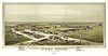
June 22, 1970 3 miles west and 2 miles north of El Reno
35°33′42″N 98°02′06″W / 35.561667°N 98.035°WEl Reno 12 William I. and Magdalen M. Goff House September 8, 1988 506 S. Evans
35°31′46″N 97°57′21″W / 35.529444°N 97.955833°WEl Reno 13 Jackson Conoco Service Station March 2, 2004 301 S. Choctaw, (121 W. Wade)
35°31′53″N 97°57′15″W / 35.531389°N 97.954167°WEl Reno 14 Henry Lassen House September 4, 2008 605 S. Hoff El Reno 15 Mennoville Mennonite Church October 4, 1979 North of El Reno on U.S. Route 81
35°38′20″N 97°57′33″W / 35.638889°N 97.959167°WEl Reno 16 Mulvey Mercantile September 20, 1982 425 W. Main
35°30′13″N 97°44′36″W / 35.503611°N 97.743333°WYukon 17 Red Cross Canteen September 5, 1975 Rock Island Depot
35°31′51″N 97°57′30″W / 35.530833°N 97.958333°WEl Reno 18 Richardson Building October 6, 1983 Northeast of Main and Division
35°23′11″N 97°56′02″W / 35.386389°N 97.933889°WUnion City 19 Rock Island Depot March 7, 1983 400 W. Wade St.
35°31′52″N 97°57′31″W / 35.531111°N 97.958611°WEl Reno 20 Southern Hotel August 2, 1978 319 S. Grand St.
35°31′50″N 97°57′27″W / 35.530556°N 97.9575°WEl Reno 21 US Highway 77 Bridge at Canadian River 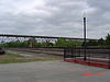
September 2, 2003 U.S. Route 77 over the Canadian River
35°00′54″N 97°20′38″W / 35.015°N 97.343889°WPurcell Extends into McClain County 22 West Point Christian Church September 2, 1983 Southwest of Yukon
35°26′57″N 97°47′40″W / 35.449167°N 97.794444°WYukon 23 Yukon Public Library February 2, 1984 512 Elm St.
35°30′24″N 97°45′02″W / 35.506667°N 97.750556°WYukon See also
- List of National Historic Landmarks in Oklahoma
- National Register of Historic Places listings in Oklahoma
References
- ^ The latitude and longitude information provided in this table was derived originally from the National Register Information System, which has been found to be fairly accurate for about 99% of listings. For about 1% of NRIS original coordinates, experience has shown that one or both coordinates are typos or otherwise extremely far off; some corrections may have been made. A more subtle problem causes many locations to be off by up to 150 yards, depending on location in the country: most NRIS coordinates were derived from tracing out latitude and longitudes off of USGS topographical quadrant maps created under the North American Datum of 1927, which differs from the current, highly accurate WGS84 GPS system used by Google maps. Chicago is about right, but NRIS longitudes in Washington are higher by about 4.5 seconds, and are lower by about 2.0 seconds in Maine. Latitudes differ by about 1.0 second in Florida. Some locations in this table may have been corrected to current GPS standards.
- ^ "National Register of Historic Places: Weekly List Actions". National Park Service, United States Department of the Interior. Retrieved on November 10, 2011.
- ^ Numbers represent an ordering by significant words. Various colorings, defined here, differentiate National Historic Landmark sites and National Register of Historic Places Districts from other NRHP buildings, structures, sites or objects.
- ^ "National Register Information System". National Register of Historic Places. National Park Service. . http://nrhp.focus.nps.gov/natreg/docs/All_Data.html.
U.S. National Register of Historic Places Topics Lists by states Alabama • Alaska • Arizona • Arkansas • California • Colorado • Connecticut • Delaware • Florida • Georgia • Hawaii • Idaho • Illinois • Indiana • Iowa • Kansas • Kentucky • Louisiana • Maine • Maryland • Massachusetts • Michigan • Minnesota • Mississippi • Missouri • Montana • Nebraska • Nevada • New Hampshire • New Jersey • New Mexico • New York • North Carolina • North Dakota • Ohio • Oklahoma • Oregon • Pennsylvania • Rhode Island • South Carolina • South Dakota • Tennessee • Texas • Utah • Vermont • Virginia • Washington • West Virginia • Wisconsin • WyomingLists by territories Lists by associated states Other National Register of Historic Places in Canadian County, Oklahoma El Reno Avant’s Cities Service Station · Canadian County Jail · Carnegie Library · El Reno High School · El Reno Hotel · El Reno Municipal Swimming Pool Bath House · William I. and Magdalen M. Goff House · Jackson Conoco Service Station · Henry Lassen House · Red Cross Canteen · Rock Island Depot · Southern Hotel · Darlington Agency Site · Fort Reno · Mennoville Mennonite Church

Geary Bridgeport Hill Service Station
Hydro Bridgeport Hill-Hydro OK 66 Segment
Purcell Union City Richardson Building (Union City)
Yukon Mulvey Mercantile · Yukon Public Library · Czech Hall · West Point Christian Church
See also: National Register of Historic Places listings in Canadian County, Oklahoma and List of National Historic Landmarks in OklahomaCategories:- Canadian County, Oklahoma
- National Register of Historic Places in Oklahoma by county
- Buildings and structures in Canadian County, Oklahoma
-


Wikimedia Foundation. 2010.