- Mount Whitney
-
This article is about the mountain. For the former town with this name, see Lone Pine Station, California. For the ship, see USS Mount Whitney (LCC-20).
Mount Whitney 
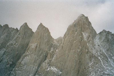
East Face close-up seen from the Whitney Portal.Elevation 14,505 ft (4,421 m) NAVD 88[1] Prominence 10,080 ft (3,072 m) [2]
Ranked 81stParent peak El Pico de Orizaba Listing Ultra, US State High Point of California, SPS Emblem peak [3] Location Location in California, USA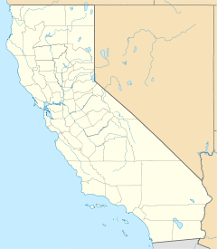
 Mount Whitney
Location Sequoia National Park / Inyo National Forest, California, USA Range Sierra Nevada Coordinates 36°34′43″N 118°17′31″W / 36.578580925°N 118.291994950°WCoordinates: 36°34′43″N 118°17′31″W / 36.578580925°N 118.291994950°W[1] Topo map USGS Mount Whitney Geology Type Granitic Age of rock Cretaceous Climbing First ascent August 18, 1873 – Charles Begole, Albert Johnson, John Lucas [4] Easiest route Mount Whitney Trail (hike)  Mount Whitney 3D map
Mount Whitney is the highest summit in the contiguous United States with an elevation of 14,505 feet (4,421 m).[1] It is on the boundary between California's Inyo and Tulare counties, 84.6 miles (136.2 km) west-northwest of the lowest point in North America at Badwater in Death Valley National Park (282 feet (86 m) below sea level).[5] The west slope of the mountain is in Sequoia National Park and the summit is the south end of the John Muir Trail which runs 211.9 miles (341.0 km) from Happy Isles in Yosemite Valley. The east slope is in the Inyo National Forest in Inyo County.
Contents
Geography
The summit of Whitney is on the Sierra Crest and near many of the highest peaks of the Sierra Nevada. The peak rises 10,778 feet (3,285 m) or just over two miles above the town of Lone Pine in the Owens Valley below.
Mount Whitney is above the tree line and has an alpine climate and ecology. Very few plants grow near the summit: one example is the Sky Pilot, a cushion plant that grows low to the ground.[6] The only animals are transient, such as the butterfly Parnassius phoebus and the Gray-crowned Rosy Finch.[6]
Elevation measurements
The estimated elevation of the summit of Mount Whitney has changed over the years. The technology of elevation measurement has become more refined and, more importantly, the vertical coordinate system has changed. The peak was commonly said to be at 14,494 feet (4,418 m) and this is the elevation stamped on the USGS brass benchmark disk on the summit. An older plaque on the summit (sheet metal with black lettering on white enamel) reads "elevation 14,496.811 feet" but this was estimated using the older vertical datum (NVGD29) from 1929. Since then the shape of the Earth (the geoid) has been estimated more accurately. Using a new vertical datum established in 1988 (NAVD88) the benchmark is now estimated to be at 14,505 feet (4,421 m).[1][7]
Geology
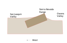 Schematic of Sierra Nevada fault-block.
The eastern slope of Whitney is far steeper than its western slope. This is because the entire Sierra Nevada is the result of a fault-block that is analogous to a door: the door is hinged on the west and is slowly rising on the east.[8] The rise is caused by a normal fault system that runs along the eastern base of the Sierra, below Mount Whitney. Thus, the granite that forms Mount Whitney is the same as the granite that forms the Alabama Hills thousands of feet below.[9] The raising of Whitney (and the downdrop of the Owens Valley) is due to the same geological forces that cause the Basin and Range Province: the crust of much of the intermontane west is slowly being stretched.[10]
The granite that forms Mount Whitney is part of the Sierra Nevada batholith. In Cretaceous time, masses of molten rock that originated from subduction rose underneath what is now Whitney and solidified underground to form large expanses of granite. In the last few million years, the Sierra has started to rise. This has enabled glacial and river erosion to strip the upper layers of rock to reveal the resistant granite that makes up Mount Whitney today.
History
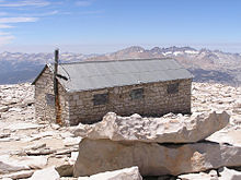
 The plaque and view at the top of Mt Whitney.
In July 1864, the members of the California Geological Survey named the peak after Josiah Whitney, the State Geologist of California and benefactor of the Survey.[4]
During the same expedition, geologist Clarence King attempted to climb Whitney from its west side, but stopped just short. In 1871, King returned to climb what he believed to be Whitney, but having taken a different approach, he actually summited nearby Mount Langley. Upon learning of his mistake in 1873, King finally completed his own first ascent of Whitney, but did so a month too late to claim the first recorded ascent.[11]
A month earlier on August 18, 1873, Charles Begole, A. H. Johnson, and John Lucas of nearby Lone Pine, had become the first to reach the highest summit in the contiguous United States. As they were fishermen, they called the mountain Fisherman's Peak.[4] But in 1891, the United States Geological Survey's Board on Geographic Names decided to recognize the earlier name of Mount Whitney. The name Whitney has remained, resisting a movement after World War II to rename the mountain for Winston Churchill.[12]
Residents of Lone Pine financed the first trail to the summit, engineered by Gustave Marsh, and completed on July 22, 1904. Just four days later, the new trail enabled the first recorded death on Whitney. Having hiked the trail, U.S. Bureau of Fisheries employee Bryd Surby was struck and killed by lightning while eating lunch on the exposed summit. In response to this event, Marsh began work on the stone hut that would become the Smithsonian Institution Shelter, and completed it in 1909.[13]
Climbing routes
Trails
 The Smithsonian Hut Shelter on Whitney's summit.
The most popular route to the summit is by way of the Mount Whitney Trail which starts at Whitney Portal (8,360 feet (2,550 m)) 13 miles (21 km) west of the town of Lone Pine. The hike is about 22 miles (35 km) round trip with an elevation gain of over 6,100 feet (1,900 m). Permits are required year round, and to prevent overuse a limited number of permits are issued by the Forest Service between May 1 and November 1.[14] Most hikers do the trip in two days. Those in good physical condition sometimes attempt to reach the summit and return to Whitney Portal in one day, thus requiring only a somewhat easier-to-obtain "day use" permit rather than the overnight permit. This is considered an "extreme" day hike, which normally involves leaving Whitney Portal before sunrise and 12 to 18 hours of strenuous hiking,[15] while struggling with altitude sickness, cold air, and occasionally treacherous surface conditions (because snow and/or ice are normally present on parts of the trail, except for a short period from early July to late September.)
Longer approaches to Whitney arrive at its west side, connecting to the Mount Whitney Trail near the summit by way of the John Muir Trail.
Scrambles
 Railings on the Mount Whitney Trail switchbacks.
The "Mountaineer's Route", a gully on the north side of the east face first climbed by John Muir, is considered a scramble.[16]
 1962 before railings, opposite view, treacherous.
The fastest recorded time up this route to the summit and back to the portal is 3 hours 10 minutes, by Jason Lakey of Bishop.[17]
Technical climbs
The steep eastern side of the mountain offers a variety of climbing challenges. The East Face route, first climbed in 1931, is a classic route in the Sierra Nevada and involves technical free climbing (Class 5.7) but is mostly Class 4. Other routes range up to Class 5.10.[16]
South of the main summit there are a series of minor summits that are completely inconspicuous from the west but appear as a series of "needles" from the east. The routes on these include some of the finest big-wall climbing in the high Sierra. Two of the needles were named after participants in an 1880 scientific expedition to the mountain. Keeler Needle was named for James Keeler and Day Needle was named for William Cathcart Day. The latter has now been renamed Crooks Peak after Hulda Crooks who hiked up Mount Whitney every year until well into her nineties.
See also
 The Needles and Whitney's East Face.
- Highest mountain peaks of California
- List of California fourteeners
- List of highest points in California by county
- List of U.S. states by elevation
- Mountain peaks of California
- Mountain peaks of North America
- Mountain peaks of the United States
- Hawthorne Nevada Airlines Flight 708: a plane that crashed into the side of Mount Whitney in 1969, killing all 35 on board.
- Badwater Ultramarathon: a 135-mile (215 km) running race from the bottom of Death Valley to Whitney Portal.
References
- ^ a b c d "Whitney". NGS data sheet. U.S. National Geodetic Survey. http://www.ngs.noaa.gov/cgi-bin/ds_mark.prl?PidBox=GT1811.
- ^ "Mount Whitney, California". Peakbagger.com. http://www.peakbagger.com/peak.aspx?pid=2829.
- ^ "Sierra Peaks Section List". Angeles Chapter, Sierra Club. http://angeles.sierraclub.org/sps/spslist.pdf.
- ^ a b c Farquhar, Francis P. (1926). Place Names of the High Sierra. San Francisco: Sierra Club. http://www.yosemite.ca.us/library/place_names_of_the_high_sierra/w.html. Retrieved 2007-08-12.
- ^ "Find Distance and Azimuths Between 2 Sets of Coordinates". Federal Communications Commission. http://www.fcc.gov/mb/audio/bickel/distance.html. Retrieved 2010-08-13.
- ^ a b Schoenherr, Allan A. (1995). A Natural History of California. University of California Press. ISBN 0520069218.
- ^ "Height Conversion Methodology". U.S. National Geodetic Survey. http://www.ngs.noaa.gov/TOOLS/Vertcon/vert_method.html. Retrieved 2008-04-09.
- ^ "Sierra Nevada". Ecological Subregions of California. US Forest Service. http://www.fs.fed.us/r5/projects/ecoregions/m261e.htm. Retrieved 2008-04-09.
- ^ Schoenherr, Allan A. (1995). A Natural History of California. UC Press. ISBN 0-520-06922-6.
- ^ "The Great Basin". Great Basin National Park. US National Park Service. http://www.nps.gov/grba/planyourvisit/the-great-basin.htm. Retrieved 2008-04-09.
- ^ King, Clarence (1902) [1872]. "Chapter XIII Mount Whitney". Mountaineering in the Sierra Nevada (10th ed.). ISBN 0585274320. http://www.yosemite.ca.us/library/mountaineering_in_the_sierra_nevada/13.html. Retrieved 2009-02-01.
- ^ "Mount Whitney". Geographic Names Information System, U.S. Geological Survey. http://geonames.usgs.gov/pls/gnispublic/f?p=gnispq:3:::NO::P3_FID:269051. Retrieved 2009-02-01.
- ^ "Mt. Whitney's Early Days". Mount Whitney History. Lone Pine Chamber of Commerce. http://www.lonepinechamber.org/history/whitneyhist2.html. Retrieved 2009-02-01.
- ^ "Recreational Activities - Mt. Whitney". US Forest Service. http://www.fs.fed.us/r5/inyo/recreation/wild/mtwhitney.shtml. Retrieved 2008-04-09.
- ^ "Mt. Whitney – One Day Hike". http://www.dayhiker.com/directory/MtWhitney.htm.
- ^ a b Steve Roper (1976). The Climber's Guide to the High Sierra. Sierra Club Books. ISBN ISBN 0-87156-147-6.
- ^ "Bishop Local Adds 5.13b Crack, And Speed Solos Whitney Region". http://rockandice.com/news/1272-bishop-local-adds-513b-crack-and-speed-solos-whitney-region.
Further reading
- Thompson, Doug; Elisabeth Newbold (1997). Mount Whitney: Mountain Lore From The Whitney Store. Westwind Publishing Company. ISBN 978-0965359603.
External links
- "Mt. Whitney Trail". Inyo National Forest. http://www.fs.usda.gov/wps/portal/fsinternet/!ut/p/c5/04_SB8K8xLLM9MSSzPy8xBz9CP0os3gDfxMDT8MwRydLA1cj72BTJw8jAwgAykeaxcN4jhYG_h4eYX5hPgYwefy6w0H24dcPNgEHcDTQ9_PIz03VL8iNMMgycVQEAHcGOlk!/dl3/d3/L2dJQSEvUUt3QS9ZQnZ3LzZfME80MEkxVkFCOTBFMktTNUJIMjAwMDAwMDA!/?ss=110504&navtype=BROWSEBYSUBJECT&cid=null&navid=110000000000000&pnavid=null&position=null&recid=20806&ttype=recarea&name=Mt.%2520Whitney%2520Trail&pname=Inyo%2520National%2520Forest%2520-%2520Mt.%2520Whitney%2520Trail.
- "Mt Whitney Hikers Association". http://www.whitneyzone.com/wz/.
- "Whitney Portal Store". http://www.whitneyportalstore.com. Retrieved 2008-04-09.
- "Mount Whitney". SummitPost.org. http://www.summitpost.org/page/150227.
- "Mount Whitney". Mount-Whitney.com. http://www.mount-whitney.com. Retrieved 2008-06-09.
- "Mt. Whitney Aerial Views". timberlinetrails.net. http://timberlinetrails.net/WhitneyAerialPhoto1.html. Retrieved 2008-09-24.
- Panorama of Mount Whitney
U.S. State Highest Natural Points Alabama • Alaska • Arizona • Arkansas • California • Colorado • Connecticut • Delaware • Florida • Georgia • Hawaii • Idaho • Illinois • Indiana • Iowa • Kansas • Kentucky • Louisiana • Maine • Maryland • Massachusetts • Michigan • Minnesota • Mississippi • Missouri • Montana • Nebraska • Nevada • New Hampshire • New Jersey • New Mexico • New York • North Carolina • North Dakota • Ohio • Oklahoma • Oregon • Pennsylvania • Rhode Island • South Carolina • South Dakota • Tennessee • Texas • Utah • Vermont • Virginia • Washington • West Virginia • Wisconsin • Wyoming
Categories:- Fourteeners of California
- United States National Park high points
- Mountains of Sequoia National Park
- Mountains of the John Muir Wilderness
- Mountains of Inyo County, California
- Mountains of Tulare County, California
- Inyo National Forest
- Symbols of California
- Highest points of U.S. states


Wikimedia Foundation. 2010.