- Charnwood (borough)
-
For the electoral ward of Leicester, see Charnwood (ward).
Borough of Charnwood — Borough — Shown within Leicestershire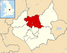
Sovereign state United Kingdom Constituent country England Region East Midlands Administrative county Leicestershire Founded Admin. HQ Loughborough Government - Type Charnwood Borough Council - Leadership: Leader & Cabinet - Executive: Conservative - MPs: Stephen Dorrell,
Nicky MorganArea - Total 107.7 sq mi (279.0 km2) Area rank 147th Population (2010 est.) - Total 166,800 - Rank Ranked 106th - Density 1,548.4/sq mi (597.8/km2) Time zone Greenwich Mean Time (UTC+0) - Summer (DST) British Summer Time (UTC+1) Postcode ISO 3166-2 ONS code 31UC OS grid reference NUTS 3 Ethnicity 91.7% White
6.0% S.Asian
1.3% Afro-CaribbeanWebsite charnwoodbc.gov.uk Charnwood is a borough of northern Leicestershire, England. It is named after Charnwood Forest, which it contains. Loughborough is the largest town in the district and serves as the borough's administrative and commercial centre.
Contents
History
The district of Charnwood was formed on 1 April 1974 as a merger of the municipal borough of Loughborough, the Shepshed urban district and the Barrow upon Soar Rural District. It was then granted borough status on 15 May 1974.[1]
The symbol of Charnwood Borough Council is the fox, historically linked with Leicestershire, and this is also the symbol used by Leicestershire County Council. However Charnwood contains Quorn, which is believed[by whom?] to be the birthplace of fox-hunting.
Geography
To the south it borders the City of Leicester, about 20 km away from Loughborough. There is a moderately urbanised A6 corridor between the towns and close to the River Soar, including Quorn, Barrow-on-Soar, Mountsorrel, Birstall, Thurmaston, Syston and East Goscote. Shepshed, to the west of Loughborough, is the other major town in the district.
Political representation
There are two Parliamentary constituencies covering the district. Charnwood is represented by the Conservative Stephen Dorrell, the former National Heritage Secretary (1994-5) and Health Secretary (1995-7) during John Major's government. Loughborough is represented by the Conservative Party's Nicky Morgan.
Demographics
Charnwood is the largest borough by population in Leicestershire, and has the largest school population as well.
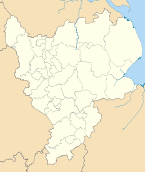
Parishes
- Anstey
- Barkby, Barkby Thorpe, Barrow upon Soar, Beeby, Birstall, Burton on the Wolds
- Cossington, Cotes
- East Goscote
- Hathern, Hoton
- Mountsorrel
- Newtown Linford
- Prestwold
- Queniborough, Quorn
- Ratcliffe on the Wreake, Rearsby, Rothley
- Seagrave, Shepshed, Sileby, South Croxton, Swithland, Syston
- Thrussington, Thurcaston and Cropston, Thurmaston
- Ulverscroft
- Walton on the Wolds, Wanlip, Woodhouse, Wymeswold
References
- ^ Charnwood Borough Council; The Mayoralty in Charnwood. Accessed 31 January 2006.
External links
Towns 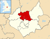
Large villages Anstey • Barrow upon Soar • Birstall • East Goscote • Mountsorrel • Quorn • Rothley • Sileby • Thurmaston
Small villages Barkby • Beeby • Burton on the Wolds • Cossington • Cropston • Hathern • Hoton • Newtown Linford • Queniborough • Ratcliffe on the Wreake • Rearsby • Seagrave • South Croxton • Swithland • Thrussington • Thurcaston • Ulverscroft • Walton on the Wolds • Wanlip • Woodhouse • Woodhouse Eaves • Wymeswold
Hamlets Unitary authorities Boroughs or districts Blaby · Charnwood · Harborough · Hinckley and Bosworth · Melton · North West Leicestershire · Oadby and WigstonMajor settlements Ashby-de-la-Zouch · Braunstone Town · Coalville · Earl Shilton · Hinckley · Kirby Muxloe · Leicester (Leicester Urban Area) · Loughborough · Lutterworth · Market Bosworth · Market Harborough · Melton Mowbray · Oadby · Shepshed · Syston · Wigston Magna
See also: List of civil parishes in LeicestershireTopics Derbyshire Amber Valley • Bolsover • Chesterfield • Derby • Derbyshire Dales • Erewash • High Peak • North East Derbyshire • South Derbyshire
Leicestershire Blaby • Charnwood • Harborough • Hinckley and Bosworth • Leicester • Melton • North West Leicestershire • Oadby and Wigston
Lincolnshire Nottinghamshire Ashfield • Bassetlaw • Broxtowe • Gedling • Mansfield • Newark and Sherwood • Nottingham • Rushcliffe
Northamptonshire Rutland Categories:- Local government in Leicestershire
- Non-metropolitan districts of Leicestershire
- Local government districts of the East Midlands
- Charnwood


Wikimedia Foundation. 2010.