- Maków County
-
Maków County
Powiat makowski— County — 
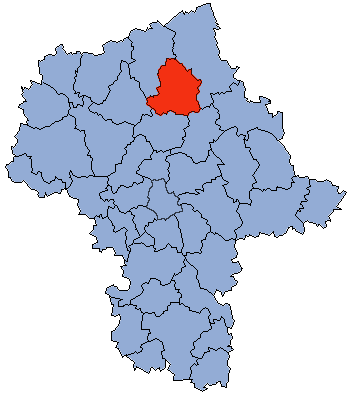
Coat of armsLocation within the voivodeship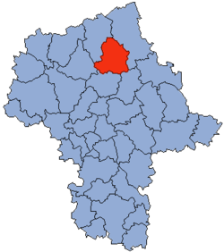 Division into gminas
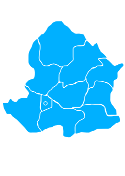
Coordinates (Maków Mazowiecki): 52°52′N 21°6′E / 52.867°N 21.1°ECoordinates: 52°52′N 21°6′E / 52.867°N 21.1°E Country  Poland
Voivodeship Masovian Seat Maków Mazowiecki Gminas Area – Total 1,064.56 km2 (411 sq mi) Population (2006) – Total 46,474 – Density 43.7/km2 (113.1/sq mi) – Urban 12,541 – Rural 33,933 Car plates WMA Website http://www.powiat-makowski.pl Maków County (Polish: powiat makowski) is a unit of territorial administration and local government (powiat) in Masovian Voivodeship, east-central Poland. It came into being on January 1, 1999, as a result of the Polish local government reforms passed in 1998. Its administrative seat and largest town is Maków Mazowiecki, which lies 73 kilometres (45 mi) north of Warsaw. The only other town in the county is Różan, lying 20 km (12 mi) east of Maków Mazowiecki.
The county covers an area of 1,064.56 square kilometres (411.0 sq mi). As of 2006 its total population is 46,474, out of which the population of Maków Mazowiecki is 9,880, that of Różan is 2,661, and the rural population is 33,933.
Neighbouring counties
Maków County is bordered by Ostrołęka County to the north-east, Wyszków County to the south-east, Pułtusk County to the south, Ciechanów County to the west and Przasnysz County to the north-west.
Administrative division
The county is subdivided into 10 gminas (one urban, one urban-rural and eight rural). These are listed in the following table, in descending order of population.
Gmina Type Area
(km²)Population
(2006)Seat Maków Mazowiecki urban 10.3 9,880 Gmina Krasnosielc rural 167.0 6,544 Krasnosielc Gmina Płoniawy-Bramura rural 135.0 5,864 Płoniawy-Bramura Gmina Karniewo rural 129.4 5,448 Karniewo Gmina Różan urban-rural 84.1 4,423 Różan Gmina Szelków rural 112.9 3,695 Szelków Gmina Sypniewo rural 128.6 3,528 Sypniewo Gmina Rzewnie rural 111.7 2,699 Rzewnie Gmina Czerwonka rural 110.6 2,646 Czerwonka Gmina Młynarze rural 75.0 1,747 Młynarze References
Seat Maków Mazowiecki (urban gmina)
Urban-rural gmina Rural gminas Counties of Masovian Voivodeship City counties 
Land counties Białobrzegi • Ciechanów • Garwolin • Gostynin • Grodzisk Mazowiecki • Grójec • Kozienice • Legionowo • Lipsko • Łosice • Maków • Mińsk • Mława • Nowy Dwór Mazowiecki • Ostrołęka • Ostrów Mazowiecka • Otwock • Piaseczno • Płock • Płońsk • Pruszków • Przasnysz • Przysucha • Pułtusk • Radom • Siedlce • Sierpc • Sochaczew • Sokołów • Szydłowiec • Warsaw West • Węgrów • Wołomin • Wyszków • Żuromin • Zwoleń • ŻyrardówCategories:- Maków County
- Land counties of Masovian Voivodeship


Wikimedia Foundation. 2010.