- Comins Coch, Ceredigion
-
For the village near Llanbrynmair in Powys, see Commins Coch.
Coordinates: 52°25′18″N 4°02′16″W / 52.4218°N 4.0379°W
Comins Coch Welsh: Comins Coch 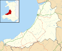
 Comins Coch
Comins Coch shown within CeredigionOS grid reference SN614823 - Cardiff 90 mi (140 km) SE Principal area Ceredigion Ceremonial county Dyfed Country Wales Sovereign state United Kingdom Post town ABERYSTWYTH Postcode district SY23 Dialling code 01970 Police Dyfed-Powys Fire Mid and West Wales Ambulance Welsh EU Parliament Wales UK Parliament Ceredigion Welsh Assembly Ceredigion List of places: UK • Wales • Ceredigion Comins Coch is a small village in Ceredigion, Wales to the north of Aberystwyth. There are approximately 1700 residents living in the village. There is a primary school, a phone box and a post box. In the school there are approx. 170 pupils.
External links
Ceredigion Principal settlements 
Towns and villages Aberarth · Aberbanc · Aberffrwd · Aberlerry · Abermagwr · Aber-meurig · Aberporth · Alltyblacca · Betws Ifan · Beulah · Blaencelyn · Borth · Bow Street · Caemorgan · Caerwedros · Capel Bangor · Capel Dewi · Ciliau Aeron · Comins Coch · Cribyn · Cwmann · Cwmystwyth · Devil's Bridge · Dôl-y-bont · Eisteddfa Gurig · Eglwys Fach · Elerch · Ffostrasol · Furnace · Glandyfi · Gorsgoch · Gwbert · Llanarth · Llanbadarn Fawr · Llanddewi Brefi · Llandre (Llanfihangel Genau'r Glyn) · Llandyfriog · Llandygwydd · Llanfarian · Llanfihangel-y-Creuddyn · Llanfihangel Ystrad · Llangeitho · Llangoedmor · Llangrannog · Llangybi · Llangynfelyn · Llanilar · Llanon · Llanrhystud · Llansantffraed · Llanwenog · Llechryd · Lledrod · Lovesgrove · Melindwr · Mwnt · Oakford · Penbryn · Penparc · Penparcau · Penrhyn-coch · Penuwch · Peny-y-garn · Ponterwyd · Pontrhydfendigaid · Pontrhydygroes · Pont-Siân · Rhydowen · Rhydypennau · Salem · Silian · Talgarreg · Tal-y-bont · Tirymynach · Trefeurig · Tregaron · Tresaith · Tre-Taliesin · Tre'r Ddôl · Troed y Rhiw · Troedyraur · Upper Borth · Waunfawr · Y Faenor · Y Ferwig · Ynyslas · Ysbyty Ystwyth · Ystrad Aeron · Ystrad Meurig · Ystumtuen
Universities Aberystwyth University · University of Wales, Trinity Saint DavidRivers Castles Islands Categories:- Villages in Ceredigion
- Ceredigion geography stubs


Wikimedia Foundation. 2010.