- Moravian-Silesian Beskids
-
Moravian-Silesian Beskids (Moravskoslezské Beskydy) Mountain Range  Smrk mountain in early spring
Countries Czech Republic, Slovakia Regions Moravian-Silesian (Czech Rep.), Žilina (Slovakia) Part of Western Beskids, Western Carpathians Parts Klokočovská hornatina, Lysohorská hornatina, Radhošťská hornatina Highest point Lysá hora - elevation 1,323 m (4,341 ft) - coordinates 49°32′45″N 18°26′51″E / 49.54583°N 18.4475°E Geology Godulian sandstone Orogeny Alpine Period Miocene 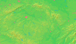
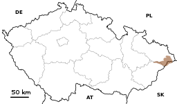 Location in the Czech Republic
 Location in the Moravian-Silesian Region
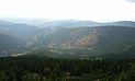
The Moravian-Silesian Beskids (Czech: Moravskoslezské Beskydy , Slovak: Moravsko-sliezske Beskydy) is a mountain range in the Czech Republic with a small part reaching to Slovakia. It lies on the historical division between Moravia and Silesia, hence the name. It's part of the Western Beskids, which is in turn part of the Outer Western Carpathians.
The mountains were created during the Alpine Orogeny in the Tertiary. Geologically, they consist mainly of flysch deposites. In the north they steeply rise nearly 1,000 m (3,300 ft) over a rather flat landscape, in the south they slowly merge with the Javorníky. In the south-west they are separated from the Vsetínské vrchy by the Rožnovská Bečva valley, in the north-east the Jablunkov Pass separates them from the Silesian Beskids.
 Čeladenka River in Moravian-Silesian Beskids
The highest point is Lysá hora mountain at 1,323 m (4,341 ft), which is one of the rainiest places in the Czech Republic with around 1,500 mm (60 in) of precipitation a year. Many legends are bound to Radhošť Mountain, 1,129 m (3,704 ft), which is one of the most visited places in the mountains together with the nearby Pustevny resort.
Smrk with a height of 1,276 m (4,186 ft) is the second highest summit of the range. Its Northern slope steeply rises from the surrounding lowlands and is separated from the rest of the mountains by the deep Ostravice River (in the East) and Čeladenka (in the West) river valleys; in the South it merges in the lower Zadní hory (i.e. Rear mountains) area.
The Moravian-Silesian Beskids create the largest part of the Beskydy Landscape Protected Area (Czech: Chráněná krajinná oblast Beskydy or Czech: CHKO Beskydy for short). The mountains are 80% forested, though mainly by plantations of spruce which were in some parts severely damaged by emissions from the Ostrava industrial region. Originally, the mountains were covered by mixed forest with dominant beech which are preserved in many places. Recently, permanent occurrence of all three large Central European carnivors – lynx, bear and wolf – have been confirmed in the area.
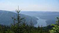 Šance Reservoir on the Ostravice River in the Moravian-Silesian Beskids
There are many popular holiday resorts for both winter and summer activities, with centers in the towns under the mountains (Frýdlant nad Ostravicí, Frenštát pod Radhoštěm, Rožnov pod Radhoštěm) and also in smaller resorts, hamlets and chalets throughout the mountains, especially on the ridges. Parts of two euroregions, the Beskydy/Beskidy and Těšínské Slezsko/Śląsk Cieszyński, reach into the Moravian-Silesian Beskids.
References
- Ludvík, Marcel (1987). Beskydy, Turistický průvodce ČSSR. Praha: Olympia. 27-031-87.
- Rohlík, Jiří (2001). Moravskoslezské Beskydy, Soubor turistických map 1:50 000. Praha: TRASA, s.r.o.. ISBN 80-85999-29-3.
- CHKO Beskydy Management. "CHKO Beskydy". http://nature.hyperlink.cz/Beskydy/index.htm. Retrieved 2007-05-05.
Bohemian Forest | Bohemian-Moravian Highlands | Brdy | Brno Highlands | Central Bohemian Uplands (České středohoří) | Doupov Mountains | Elbe Sandstone Mountains | Fichtelgebirge (Smrčiny) | Giant Mountains (Krkonoše) | Hostýnsko-vsetínská hornatina | Hrubý Jeseník | Javorníky | Jizera | Lusatian Mountains | Moravian-Silesian Beskids | Ore Mountains (Krušné hory) | Upper Palatinate Forest
Silesia topics History Symbols Coats of arms · Flags · Unofficial Anthems: Schlesien Unvergessene Heimat · Schlesierlied · Slezská hymnaEconomy Tourism · Upper Silesian Coal Basin (with: Upper Silesian Industrial Region · Rybnik Coal Area · Ostrava-Karviná Coal Area) · Lower Silesian Coal Basin · Legnicko-Głogowski Okręg Miedziowy · Bielski Okręg Przemysłowy · Silesian metropolitan area · Katowice urban areaCuisine Silesian dumplings · Black noodles · Makówki · Siemieniotka · Żur śląski · Wodzionka · Szałot · Kreple · Kołocz · Galert · Krupniok · Karminadle · Bryja · Moczka · Modra kapusta · Ciapkapusta · HauskyjzaLanguages Silesian (Cieszyn Silesian dialect · Lach Silesian dialect · Niemodlin Silesian dialect · Bytom Silesian dialect · Jabłonków Silesian dialect · Namysłów Silesian dialect · Prudnik Silesian dialect · Opole Silesian dialect · Syców Silesian dialect · Lower Silesian dialect · Sulkovian Silesian dialect · Texas Silesian) · German · Polish · Czech · Lower SilesianAdministrative
divisionsFormerDuchies (Piasts · Dukes) · Silesian Voivodeship (1920–1939) (Parliament · Treasury · Politicians) · State country · Province of Silesia / Upper Silesia / Lower Silesia · Sudetenland · New Silesia · Austrian Silesia · Eastern SilesiaPresentSilesian · Opole · Lower Silesian · Lubusz Voivodeships · Silesian-Moravian Region · Jeseník District · part of Saxony and Brandenburg (mainly in Niederschlesischer Oberlausitzkreis/Görlitz (district))Geography MountainsRiversLakesHighlands
Lowlands
OtherSilesian Highlands · Silesian Lowlands · Silesian-Lusatian Lowlands · Silesian Foothills · Silesian-Moravian Foothills · Oświęcim Valley · Ostrava Valley · Jelenia Góra valley · Kłodzko Valley · Zielona Góra Acclivity · Wał Trzebnicki · Przedgórze Sudeckie · Obniżenie Milicko-Głogowskie · Silesia Walls · Lower Silesian Wilderness · Silesian PrzesiekaOther Silesians · Silesian regional costumes (Śląskie stroje ludowe) · Silesian Autonomy Movement · Landsmannschaft Schlesien · Silesian architecture · Silesia national football team · Silesian Stadium · Silesian Football Association · Silesian-Moravian Football League · Silesian (European Parliament constituency) · Lower Silesian and Opole (European Parliament constituency) · Evangelical Church of Berlin-Brandenburg-Silesian Upper Lusatia · Silesian Evangelical Church of Augsburg Confession · FamilokWikiProject Silesia · Portal Categories:- Moravian-Silesian Beskids
- Mountain ranges of the Western Carpathians


Wikimedia Foundation. 2010.