- Courteenhall
-
Coordinates: 52°10′16″N 0°53′28″W / 52.171°N 0.891°W
Courteenhall 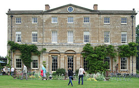
Courteenhall House
pictured during the biennial Fête,
Saturday 7 June 2008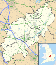
 Courteenhall
Courteenhall shown within NorthamptonshirePopulation 95 (2010 est)[1] OS grid reference SP760530 - London 65 miles (105 km) Parish Courteenhall (Annual Meeting)
Roade(Adiministration)District South Northamptonshire Shire county Northamptonshire Region East Midlands Country England Sovereign state United Kingdom Post town NORTHAMPTON Postcode district NN7 Dialling code 01604 Police Northamptonshire Fire Northamptonshire Ambulance East Midlands EU Parliament East Midlands UK Parliament South Northamptonshire List of places: UK • England • Northamptonshire Courteenhall is a village 5 miles (8 km) south of the county town of Northampton, in the shire county of Northamptonshire, England, and about 66 miles (106 km) north of London. The village is located in a cul-de-sac.
 The church of St Peter and St Paul
Contents
Governance
The village is in South Northamptonshire, and is part of Blisworth and Roade ward. It is within the Northamptonshire County Council area. From the 2010 General Election it is in the new Parliamentary Constituency of South Northamptonshire (previously Northampton South).
Location
The M1 motorway between junctions 14 and 15 passes to the northeast of the village, and junction 15 is just 1 mile distant. The main part of the village is on a no-through route. Roade Parish Council covers the area of the village as well as Roade itself, though the village still has its own annual Parish Meeting for electors of Courteenhall parish only
Facilities
The parish had a population of less than 100 in 2003, has no facilities other than a church and relies on the nearby village of Roade for shops, schools and other services. The post office in Courteenhall, which opened in 1883, closed in February 1996. The church is in the Five Parishes Group together with Collingtree, Roade, Ashton and Hartwell.
History
Church of St Peter and St Paul
The church dates from the 12th century.[2] It is now part of the "The Five Parishes" group of local churches.[3] The former Rectory is next to the south side of the church. The church has some memorable tombs.[4] In 1851 a Church Attendance Census revealed that in Courteenhall, one of the three villages in the 'Three Parishes' church grouping (see links), out of a total population of 127, 100 people attended Courteenhall Church on census day, held in England on years ending in the digit '1'. Of course, particular 'circumstances' prevailed in the Victorian estate villages affecting individual behaviour. The Rectory next to the church dates from 1805.
The Hall
The village has grown up on the estate around the house or hall known as the Courteenhall Estate,[5] which was purchased from Richard Ouseley by Sir Samuel Jones in 1647. The landscaped park covers about 370 acres (150 ha), with formal gardens close to the house.[6] The park was designed in 1791 by Humphry Repton sic[4][5] for Sir William Wake, 9th Bart. The Wake family is reputedly descended from Hereward the Wake, a Saxon hero of resistance to the Norman conquest of England.[7] Samuel's estates were inherited by his great nephew Samuel Wake, a younger son of Sir William Wake, 3rd Baronet of Piddington. Courteenhall (the Hall) is still occupied by the Wake family. The Hall, like the park, dates from 1791 and is by a little known architect Samuel Saxon.[5] It is private property but may be viewed in the distance from Courteenhall village church. Although sheep graze over the grounds of the main park, they are kept out of the Hall's garden by a ha-ha.
The Stables and School House
 The hall from the church
Built around 1750 in the Palladian style and contrast with the house. There is also in the grounds the former Free Grammar School House of about 1680, under the will of Sir Samuel Jones[2] containing its original school furnishings including a raised seat for the school master.
Visitors
The venue is rarely open to the public but available for private hire.[5] If visiting the village, please note that it is at the end of a narrow cul-de-sac road and has very limited parking. It is better to park outside the village and use one of the many public footpaths for access. Parking during the fête is via the main drive from the A508 Northampton to Milton Keynes road only.
Biennial Fête
A large biennial fête is held during June in even-numbered years, which is an opportunity to see the house (exterior only), and grounds including an extensive arboretum. The event raises several thousand pounds for the upkeep of the church, parts of which are over 800 years old.
Notable people
- Sir Richard Lane (1584–1650) Chief Baron of the Exchequer and Lord Keeper of the Great Seal to Charles I
References
- ^ SNC (2010). South Northamptonshire Council Year Book 2010-2011. Towcester NN12 7FA. pp. 39.
- ^ a b Pevsner, Nikolaus (1961). The Buildings of England – Northamptonshire. London and New Haven: Yale University Press. ISBN 978-0-300-09632-3.
- ^ "Five Parishes Group: Roade, Collingtree, Ashton, Hartwell and Courteenhall". http://www.achurchnearyou.com/courteenhall-st-peter-st-paul/. Retrieved 23 May 2010.
- ^ a b Norwich, John Julius, Lord Norwich (1985). The Architecture of Southern England. Macmillan. pp. pp768 total. ISBN 978-0333-220-375.
- ^ a b c d "Courteenhall Estate website". http://www.courteenhall.co.uk/. Retrieved 2008-10-02.
- ^ Parks and Gardens UK - based on the English Heritage Register of Parks and Gardens of Special Historic Interest
- ^ Timothy Mole and Clare Hickman (2008). The Historic Gardens of England: Northamptonshire. Stroud, Gloucestershire, England: Tempus Publishing. pp. 106–111;plates 13–14. ISBN 978-0-7524-4568-7.
External links
Categories:- Villages in Northamptonshire
- Buildings and structures in Northamptonshire
- History of Northamptonshire
- Visitor attractions in Northamptonshire
- Country houses in Northamptonshire


Wikimedia Foundation. 2010.