- Choptank River Light
-
Choptank River Light 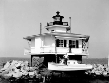
Undated photograph of Choptank River Light, Maryland (USCG) Location southeast of Bernoni Point at the mouth of the Tred Avon River, SE of Oxford, Maryland Coordinates 38°39′20″N 76°11′08″W / 38.6555°N 76.1855°WCoordinates: 38°39′20″N 76°11′08″W / 38.6555°N 76.1855°W Year first lit 1871 (second light in 1921) Deactivated 1964 Foundation screw-pile Construction cast-iron/wood Tower shape hexagonal house Original lens sixth-order Fresnel lens (replaced with fifth-order lens in 1881 The Choptank River Light was a screw-pile lighthouse located near Oxford, Maryland. In its second incarnation it was the only such light moved from another location in the Chesapeake Bay.
History
The first light at this location was built in 1871 by Francis A. Gibbons, replacing a lightship which was stationed there the previous year. A ten pile arrangement similar to that of the York Spit Light in Virginia was used. Initially equipped with a sixth-order Fresnel lens, it was upgraded to a fifth order lens in 1881 after ice piled up around the foundation and disturbed some of the outer piles, tilting the house slightly. A second ice flow in 1918 piled up 30 feet (9.1 m), knocking the house from the piles and destroying it.
Although consideration was given to using a caisson structure, it was decided instead to reuse the house from the Cherrystone Bar Light, which had been deactivated in 1919. This was moved by barge and placed on a new six pile foundation in 1921, making the new light the only working lighthouse to be moved from one location to another in the bay. This light lasted until 1964, when the house was dismantled as part of the general program of eliminating such lights; a skeleton tower on the old piles replaced it.
A replica of the light is being built on the waterfront in Cambridge, Maryland.
References
- "Historic Light Station Information and Photography: Maryland". United States Coast Guard Historian's Office. http://www.uscg.mil/history/weblighthouses/LHMD.asp.
- Choptank River Light, from the Chesapeake Chapter of the United States Lighthouse Society
- de Gast, Robert (1973). The Lighthouses of the Chesapeake. Johns Hopkins University Press. p. 164.
External links
- Choptank River Lighthouse replica project
- Rowlett, Russ. "Lighthouses of the United States: Maryland". The Lighthouse Directory. University of North Carolina at Chapel Hill. http://www.unc.edu/~rowlett/lighthouse/md.htm.
 Categories:
- Lighthouses in Maryland


Wikimedia Foundation. 2010.