- Denison, Iowa
-
Denison, Iowa — City — Downtown Denison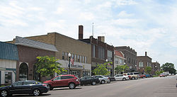 Location of Denison, Iowa
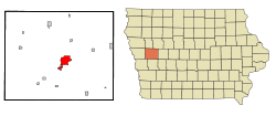
Coordinates: 42°1′2″N 95°21′4″W / 42.01722°N 95.35111°WCoordinates: 42°1′2″N 95°21′4″W / 42.01722°N 95.35111°W Country USA State  Iowa
IowaCounty Crawford Area – Total 6.2 sq mi (16.1 km2) – Land 6.2 sq mi (16.0 km2) – Water 0.0 sq mi (0.1 km2) Elevation 1,283 ft (391 m) Population (2000) – Total 7,339 – Density 1,185.5/sq mi (457.7/km2) Time zone Central (CST) (UTC-6) – Summer (DST) CDT (UTC-5) ZIP code 51442 Area code(s) 712 FIPS code 19-19945 GNIS feature ID 0455880 Denison is a city in Crawford County, Iowa, United States, along the Boyer River. The population was 7,339 at the 2000 census. It is the county seat of Crawford County.[1]
Contents
Geography
Denison is located at 42°1′2″N 95°21′4″W / 42.01722°N 95.35111°W (42.017187, −95.351124).[2]
According to the United States Census Bureau, the city has a total area of 6.2 square miles (16 km2), of which, 6.2 square miles (16 km2) of it is land and 0.04 square miles (0.10 km2) of it (0.48%) is water.
Demographics
Denison Historical Population Year Pop. ±% 1870 326 — 1880 1,441 +342.0% 1890 1,782 +23.7% 1900 2,771 +55.5% 1910 3,133 +13.1% 1920 3,581 +14.3% 1930 3,905 +9.0% 1940 4,361 +11.7% 1950 4,554 +4.4% 1960 4,930 +8.3% 1970 6,218 +26.1% 1980 6,675 +7.3% 1990 6,604 −1.1% 2000 7,339 +11.1% 2010 8,298 +13.1% Source: "American FactFinder". United States Census Bureau. http://factfinder.census.gov. As of the census[3] of 2000, there were 7,339 people, 2,674 households, and 1,756 families residing in the city. The population density was 1,185.5 people per square mile (457.8/km²). There were 2,837 housing units at an average density of 458.3 per square mile (177.0/km²). The racial makeup as reported by the Census was 86.92% White, 1.59% African American, 0.45% Native American, 0.82% Asian, 0.01% Pacific Islander, 9.02% from other races, and 1.19% from two or more races. Hispanic or Latino of any race were 17.36% of the population.
Racial diversity in Dension has been increasing since the mid-1980s. According to a New York Times article, in 2005, 20% of highschool age children identify as a racial minority compared to approximately 50% of kindergarteners.[4]
There were 2,674 households out of which 31.7% had children under the age of 18 living with them, 51.9% were married couples living together, 9.1% had a female householder with no husband present, and 34.3% were non-families. 28.9% of all households were made up of individuals and 15.0% had someone living alone who was 65 years of age or older. The average household size was 2.53 and the average family size was 3.08.
In the city the population was spread out with 26.0% under the age of 18, 11.2% from 18 to 24, 26.3% from 25 to 44, 19.3% from 45 to 64, and 17.2% who were 65 years of age or older. The median age was 35 years. For every 100 females there were 95.3 males. For every 100 females age 18 and over, there were 92.3 males.
The median income for a household in the city was $33,187, and the median income for a family was $41,362. Males had a median income of $30,145 versus $20,538 for females. The per capita income for the city was $15,391. About 6.1% of families and 12.1% of the population were below the poverty line, including 9.7% of those under age 18 and 4.2% of those age 65 or over.
The book on Denison
Pulitzer Prize-winning author Dale Maharidge depicts a changing Denison in the early twenty-first century in his book DENISON, IOWA: Searching for the Soul of America Through the Secrets of a Midwest Town. This book features photographs by Maharidge's partner and fellow Pulitzer-winner, Michael Williamson.
Notable people
- Clarence Duncan Chamberlin, aviation pioneer
- James Perry Conner (1851–1924) five-term US Representative from 1900–1909[5]
- Jim Garrison, New Orleans District Attorney who investigated some of the Kennedy assassination conspiracy theories
- James E. Hansen, head of NASA's Goddard Institute for Space Studies
- Jordan Monroe, Playboy's Playmate of the Month for October 2006.
- Donna Reed, Academy Award-winning actress; the Donna Reed Foundation's headquarters are likewise in Denison.
- L.M. Shaw (1848–1932) 17th Governor of Iowa and United States Secretary of the Treasury[6]
National Register of Historic Places
- Carey House
- Clarence D. Chamberlin House
- Crawford County Courthouse
- Park Motel
- William A. McHenry House
- Yellow Smoke Park Bridge
References
- ^ "Find a County". National Association of Counties. http://www.naco.org/Counties/Pages/FindACounty.aspx. Retrieved 2011-06-07.
- ^ "US Gazetteer files: 2010, 2000, and 1990". United States Census Bureau. 2011-02-12. http://www.census.gov/geo/www/gazetteer/gazette.html. Retrieved 2011-04-23.
- ^ "American FactFinder". United States Census Bureau. http://factfinder.census.gov. Retrieved 2008-01-31.
- ^ In This Small Town in Iowa the Future Speaks Spanish, September 14, 2005 on NYTimes.com. Accessed Nov 24, 2006.
- ^ "CONNER, James Perry". Biographical Directory of the United States Congress. http://bioguide.congress.gov/scripts/biodisplay.pl?index=C000690. Retrieved March 19, 2011.
- ^ "Iowa Governor Leslie Mortier Shaw". National Governors Association. http://www.nga.org/cms/home/governors/past-governors-bios/page_iowa/col2-content/main-content-list/title_shaw_leslie.html. Retrieved 2011-08-02.
External links
- Official Denison City Website
- Denison Community Schools The Monarchs
- City Data Comprehensive Statistical Data and more about Denison, Iowa
Municipalities and communities of Crawford County, Iowa County seat: DenisonCities 
Townships Boyer | Charter Oak | Denison | East Boyer | Goodrich | Hanover | Hayes | Iowa | Jackson | Milford | Morgan | Nishnabotny | Otter Creek | Paradise | Soldier | Stockholm | Union | Washington | West Side | Willow
Footnotes ‡This populated place also has portions in an adjacent county or counties
Categories:- Cities in Iowa
- Populated places in Crawford County, Iowa
- County seats in Iowa


Wikimedia Foundation. 2010.