- Darrang district
-
Darrang district
দৰং— District — An entrance to Manas National Park, Darrang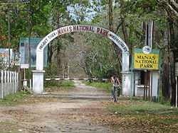 Darrang district's location in Assam
State Assam Country India Seat Mangaldai Population (2011) – Total 908,090 Time zone IST (UTC+05:30) ISO 3166 code IN-AS-DA Website http://darrang.gov.in/ Darrang (Assamese: দৰং) is an administrative district in the state of Assam in India. The district headquarters are located at Mangaldai. The district occupies an area of 3481 km².
Contents
History
In 1983 Sonitpur district was formed from part of Darrang. [1] This was repeated on 14 June 2004 with the creation of Udalguri district.[1]
Geography
Darrang district occupies an area of 3,481 square kilometres (1,344 sq mi),[2] comparatively equivalent to Bahamas's North Andros Island.[3] The main place of attraction in Darrang is Bhairabkund. Bhairabkund is a famous picnic spot in Assam. Geographically it shares the border with Bhutan and Arunachal Pradesh. Bhairabkund is a must see place in Assam. The other important towns in Darrang are Udalguri, Tangla, Sipajhar, Rowta, Kharupetia, Kalaigaon.
Divisions
There are four Assam Legislative Assembly constituencies in this district: Kalaigaon, Sipajhar, Mangaldoi, and Dalgaon.[4] Mangaldoi is designated for scheduled castes.[4] All four are in the Mangaldoi Lok Sabha constituency.[5]
Demographics
According to the 2011 census Darrang district has a population of 908,090 ,[6] roughly equal to the nation of Fiji[7] or the US state of Delaware.[8] This gives it a ranking of 463rd in India (out of a total of 640).[6] The district has a population density of 491 inhabitants per square kilometre (1,270 /sq mi) .[6] Its population growth rate over the decade 2001-2011 was 19.51 %.[6] Darrang has a sex ratio of 923 females for every 1000 males,[6] and a literacy rate of 64.55 %.[6]
868,532 (57.74%) are Hindus, 534,658 (35.54%) are Muslims, and 97,306 (1.75%) are Christians.[9]Flora and fauna
In 1990 Darrang district became home to Manas National Park, which has an area of 500 km2 (193.1 sq mi).[10] It shares the park with four other districts. It is also home to Orang National Park, which it shares with Sonitpur district. Orang was established in 1999 and has an area of 79 km2 (30.5 sq mi).[10] Apart from the two national parks, it's also home to a wildlife sanctuary: the Barnodi.[10]
References
- ^ a b Law, Gwillim (2011-09-25). "Districts of India". Statoids. http://www.statoids.com/yin.html. Retrieved 2011-10-11.
- ^ Srivastava, Dayawanti et al. (ed.) (2010). "States and Union Territories: Assam: Government". India 2010: A Reference Annual (54th ed.). New Delhi, India: Additional Director General, Publications Division, Ministry of Information and Broadcasting (India), Government of India. pp. 1116. ISBN 978-81-230-1617-7.
- ^ "Island Directory Tables: Islands by Land Area". United Nations Environment Program. 1998-02-18. http://islands.unep.ch/Tiarea.htm. Retrieved 2011-10-11. "North Andros Island 3,439km2"
- ^ a b "List of Assembly Constituencies showing their Revenue & Election District wise break - up". Chief Electoral Officer, Assam website. http://ceoassam.nic.in/Gen_Informations/2.1%20-%20DEOs%20wise%20ACs%20breakup.pdf. Retrieved 26 September 2011.
- ^ "List of Assembly Constituencies showing their Parliamentary Constituencies wise break - up". Chief Electoral Officer, Assam website. http://ceoassam.nic.in/Gen_Informations/2.2%20-%20PC-wise%20LAC%20breakup.pdf. Retrieved 26 September 2011.
- ^ a b c d e f "District Census 2011". Census2011.co.in. 2011. http://www.census2011.co.in/district.php. Retrieved 2011-09-30.
- ^ US Directorate of Intelligence. "Country Comparison:Population". https://www.cia.gov/library/publications/the-world-factbook/rankorder/2119rank.html. Retrieved 2011-10-01. "Fiji 883,125 July 2011 est."
- ^ "2010 Resident Population Data". U. S. Census Bureau. http://2010.census.gov/2010census/data/apportionment-pop-text.php. Retrieved 2011-09-30. "Delaware 897,934"
- ^ "Demographic Features of the District". http://darrang.gov.in/darrang_files/demography.htm. Retrieved 2009-10-19.
- ^ a b c Indian Ministry of Forests and Environment. "Protected areas: Assam". http://oldwww.wii.gov.in/envis/envis_pa_network/index.htm. Retrieved September 25, 2011.
External links

Udalguri district Kamrup district 
Sonitpur district  Darrang district

Marigaon district Minority Concentrated Districts in India Andaman & Nicobar Islands Arunachal Pradesh Assam Barpeta · Bongaigaon · Cachar · Darrang · Dima Hasao · Dhubri · Goalpara · Hailakandi · Kamrup · Karimganj · Kokrajhar · Marigaon · Nagaon
Bihar Delhi Haryana Jammu & Kashmir Jharkhand Karnataka Kerala Madhya Pradesh Maharashtra Manipur Meghalaya Mizoram Orissa Uttar Pradesh Baghpat · Bahraich · Balrampur · Barabanki · Bareilly · Bijnor · Budaun · Bulandshahar · Ghaziabad · Jyotiba Phule Nagar · Kheri · Lucknow · Meerut · Moradabad · Muzaffarnagar · Pilibhit · Rampur · Saharanpur · Shahjahanpur · Shravasti · Siddharth NagarUttarakhand West Bengal Bardhaman · Birbhum · Cooch Behar · Dakshin Dinajpur · Howrah · Kolkata · Malda · Murshidabad · Nadia · North 24 Parganas · South 24 Parganas · Uttar DinajpurCoordinates: 26°45′N 92°30′E / 26.75°N 92.5°E
Categories:- Darrang district
- Districts of Assam
- Minority Concentrated Districts in India
- Assam geography stubs


Wikimedia Foundation. 2010.