- Nanticoke, Pennsylvania
-
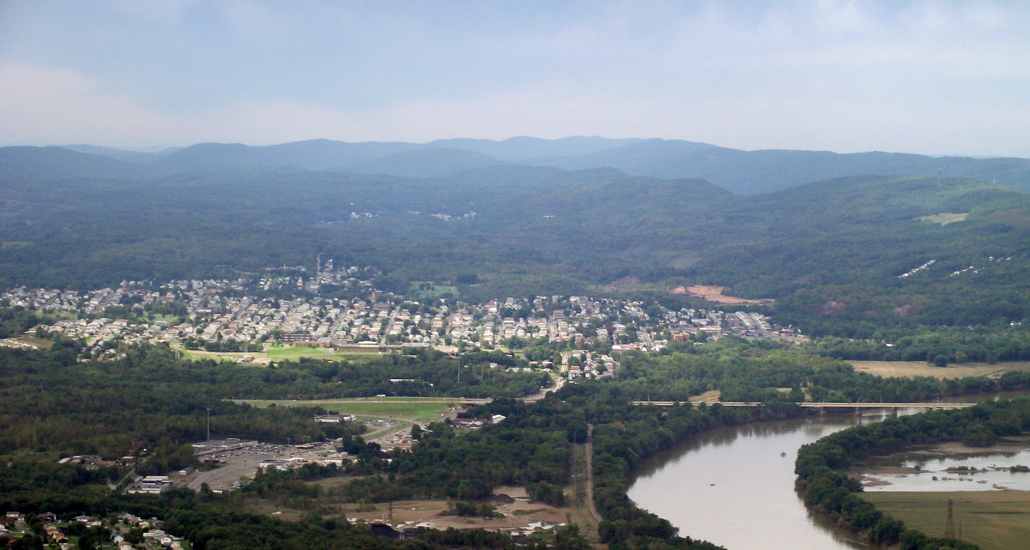
Nanticoke, Pennsylvania — City — Aerial view of Nanticoke, looking southwest.
 Nanticoke, Pennsylvania
Coordinates: 41°11′58″N 75°59′57″W / 41.19944°N 75.99917°WCoordinates: 41°11′58″N 75°59′57″W / 41.19944°N 75.99917°W Country United States State Pennsylvania County Luzerne Settled 1800 Incorporated (borough) 1874 Incorporated (city) 1926 Government – Type City Council – Mayor John Bushko Area – Total 3.6 sq mi (9.3 km2) – Land 3.5 sq mi (9.1 km2) – Water 0.1 sq mi (0.3 km2) Elevation 696 ft (212 m) Population (2010) – Total 10,465 – Density 2,906.9/sq mi (1,122.4/km2) Time zone Eastern (EST) (UTC-5) – Summer (DST) EDT (UTC-4) Zip code 18634 Area code(s) 570 Nanticoke is a city in Luzerne County, Pennsylvania, United States. The population was 10,465 at the 2010 census.
Contents
History
The name Nanticoke was derived from Nantego, the Indian tidewater people who moved here when their Maryland lands were spoiled for hunting by the colonial settlement in 1608.
Nanticoke was incorporated as a village in 1830; Nanticoke was chartered by the Pennsylvania Legislature as a borough on January 31, 1874.
Nanticoke experienced its greatest increase in population between 1917 and 1925 and qualified to become a Third Class City. The citizens voted in the fall of 1924 to form a city government, and elections were held the following year. The new city government consisted of a Mayor and four Councilmen who took office in January 1926, which was the official date of becoming a Third Class City.[1]
Samuel H. Kress opened his first store, which grew into the national S. H. Kress & Co. chain, in Nanticoke.
The Concrete City, built by the Delaware, Lackawanna and Western Railroad's coal division in 1911 to house its workers, is located near the Hanover section of Nanticoke. Abandoned since 1924, it was designated an historic site in 1998, and its remains still stand as a tourist attraction. The original road that used to run to the structures has been bulldozed, though it still remains on maps. There is an alternate entrance route that does not appear on maps. It can be found at the end of Bliss & Mosier St's - Hanover section of Nanticoke
Kosciuszko Street in Nanticoke is famous for being the only road in the United States to have located on it institutions covering all educational levels.[2][citation needed] The Nanticoke Elementary/Middle/High Schools and the Luzerne County Community College are all located on Kosciuszko Street.
Nanticoke city officials voted unanimously to apply to the state for Act 47, or economically distressed city status, which was granted in 2006. Nanticoke faced a projected $700,000 deficit that year, with revenues flat and falling far behind expenses.
Government officials
- Mayor: Joseph Dougherty
- City Council
- Margaret Haydock
- Michael Borowski
- James Litchkofski
- Jon Metta
- City Administrator: Holly M. Quinn
- City Treasurer: Albert Wytoshek
- City Controller: Kevin Coughlin
- City Solicitor: William T. Finnegan, Jr
- City Clerk: Mary Beth Cheshinski
- Fiscal Manager: Holly M. Quinn
- Police Chief: James Cheshinski
- Fire Chief: Michael Bohan
- Building Inspector/Code Enforcement: Joseph Kordek
- Zoning Officer: Andrew Kratz
Geography
Nanticoke is located at 41°11′58″N 75°59′57″W / 41.19944°N 75.99917°W (41.199514, -75.999119)[3].
According to the United States Census Bureau, the city has a total area of 3.6 square miles (9.3 km2), of which 3.5 square miles (9.1 km2) is land and 0.1 square miles (0.26 km2), or 3.05%, is water.
Demographics
At its height in the 1930s the city of Nanticoke was home to over 27,000 people. As of the census[4] of 2000, there were 10,955 people, 4,850 households, and 2,905 families residing in the city. The population density was 3,124.0 people per square mile (1,205.1/km²). There were 5,487 housing units at an average density of 1,564.7 per square mile (603.6/km²). The racial makeup of the city was 98.84% White, 0.27% African American, 0.10% Native American, 0.26% Asian, 0.01% Pacific Islander, 0.16% from other races, and 0.37% from two or more races. Hispanic or Latino of any race were 0.45% of the population.
There were 4,850 households out of which 23.5% had children under the age of 18 living with them, 42.6% were married couples living together, 12.7% had a female householder with no husband present, and 40.1% were non-families. 35.7% of all households were made up of individuals and 20.0% had someone living alone who was 65 years of age or older. The average household size was 2.21 and the average family size was 2.88.
In the city the population was spread out with 19.7% under the age of 18, 7.5% from 18 to 24, 25.8% from 25 to 44, 23.7% from 45 to 64, and 23.3% who were 65 years of age or older. The median age was 43 years. For every 100 females there were 87.6 males. For every 100 females age 18 and over, there were 83.3 males.
The median income for a household in the city was $26,169, and the median income for a family was $35,444. Males had a median income of $30,125 versus $20,265 for females. The per capita income for the city was $15,348. About 11.5% of families and 15.8% of the population were below the poverty line, including 24.1% of those under age 18 and 11.4% of those age 65 or over.
Ancestries: Polish (49.7%), German (13.0%), Irish (10.8%), Italian (8.4%), Welsh (6.4%), Slovak (5.3%).
Population trends
1900 12,116 1910 18,877 1920 22,614 1940 24,387 2010 10,465 Notable people
- Nick Adams, actor, (Mister Roberts, Rebel Without a Cause), best known to audiences as Johnny Yuma of the TV series The Rebel
- Steve Bilko, 20 years old when he broke into professional baseball on September 22, 1949, with the St. Louis Cardinals
- Pete Gray, the only one-armed man ever to play major league baseball, having lost his right arm in a childhood accident. His life is depicted in the 1986 television production A Winner Never Quits. There is a historical marker in the Hanover section of Nanticoke at Front and Center St. denoting the place of his birth.
- Paul E. Kanjorski, former U.S. Representative for Pennsylvania's 11th congressional district (which includes Nanticoke)
- Jerry Orbach, Tony-winning actor and former cast member of Law & Order
- Albert Tannenbaum, member of Murder, Inc., born in Nanticoke
References
- ^ http://www.luzernecounty.org/living/municipalities/city_of_nanticoke
- ^ K.M. Smith on Robert St. in Sheatown is the home for grades K-1.
- ^ "US Gazetteer files: 2010, 2000, and 1990". United States Census Bureau. 2011-02-12. http://www.census.gov/geo/www/gazetteer/gazette.html. Retrieved 2011-04-23.
- ^ "American FactFinder". United States Census Bureau. http://factfinder.census.gov. Retrieved 2008-01-31.
External links
- City of Nanticoke official website
- City-Data Photo Tour of Nanticoke
- Greater Nanticoke School District
- Historical marker for the Concrete City
- Nanticoke PA Online
- Nanticoke Miner's Monument
- NanticokeHistoryOnline.org
Counties Settlements
50k-100kSettlements
25k-50kSettlements
10k-25kCategories:- Cities in Pennsylvania
- Populated places on the Susquehanna River
- Populated places established in 1800
- Populated places in Luzerne County, Pennsylvania


Wikimedia Foundation. 2010.