- M-63 (Michigan highway)
-
M-63
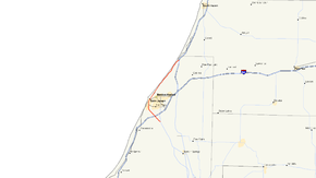
M-63 highlighted in redRoute information Maintained by MDOT Length: 16.141 mi[3] (25.976 km) Existed: 1986[1][2] – present Tourist
routes:Lake Michigan Circle Tour Major junctions South end:  M-139 at Scottdale
 I-94 / BL I-94 at St. Joseph
North end: 
 I-196 / US 31 near Hagar Shores
Location Counties: Berrien Highway system Michigan State Trunkline Highway System
Interstate • US • State←  M-62
M-62M-64  →
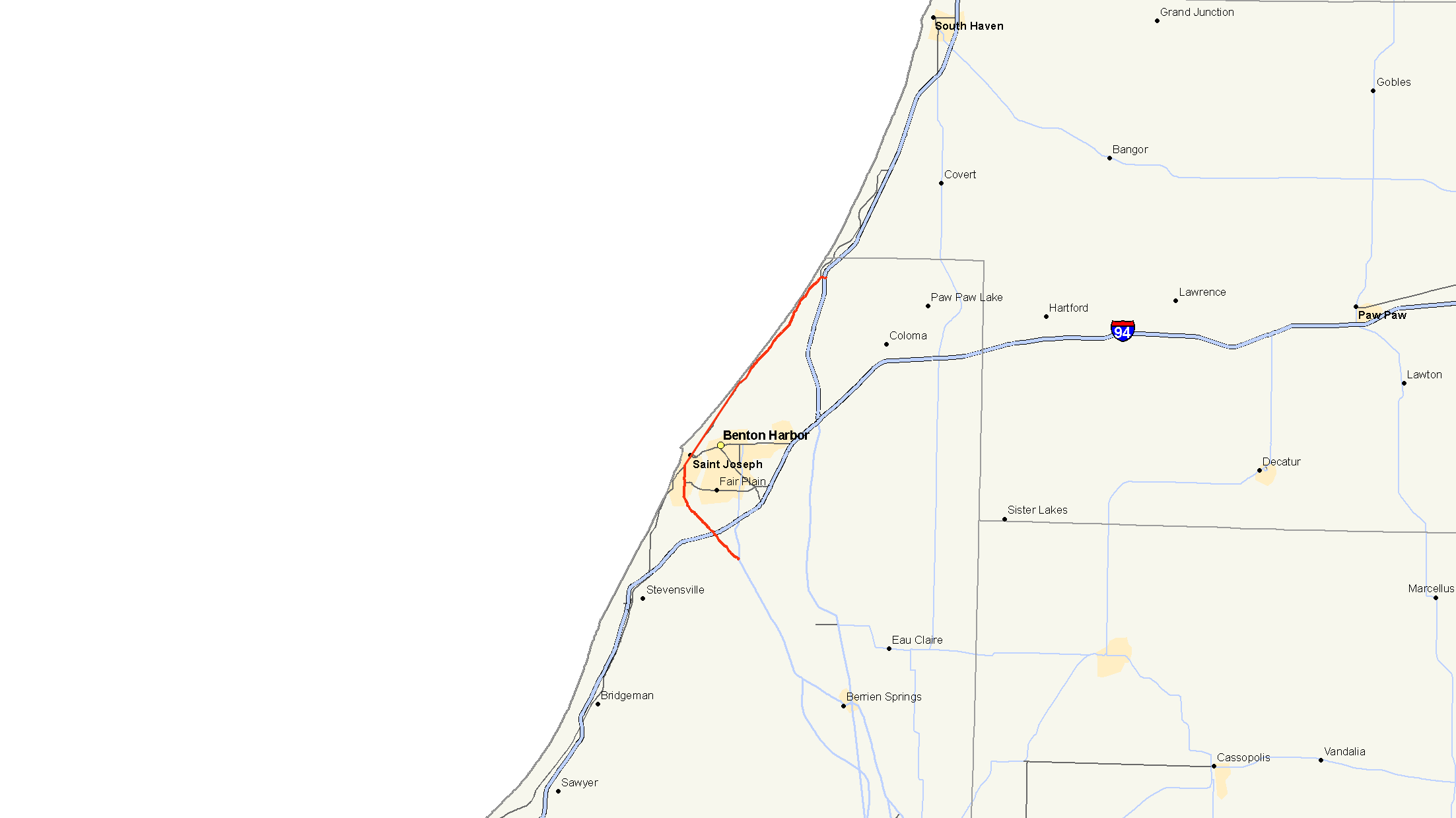
→M-63 is a state trunkline highway in the US state of Michigan that runs from M-139 at Scottdale through the cities of Benton Harbor and St. Joseph to Interstate 196/US Highway 31 (I-196/US 31) at exit 7 just outside Hagar Shores. The trunkline runs through residential areas south of St. Joseph and through the central business districts of the twin cities. Further north, M-63 runs along the Lake Michigan shoreline.
All of M-63's routing was part of US 33 before that highway's truncation south of Niles in 1986. A previous designation of M-63 was used farther north in Lake and Osceola counties from 1919 until 1961. Since the current designation was created, the Michigan Department of Transportation (MDOT) has worked on reconfiguring parts of the roadway in the early part of the 21st century. The bridge M-63 uses to cross the St. Joseph River has been identified as an historic structure using a rare design. The bridge itself dates back to the late 1940s.
Contents
Route description
M-63 begins at the intersection of Niles, Scottdale and Miners roads southwest of St. Joseph in Royalton Township. M-139 runs on Niles Road northwest from Berrien Springs to this point and on Scottdale Road north of the intersection. M-63 follows Miners Road west and then Niles Road northwest of the junction, parallel to the St. Joseph River through residential areas on the outskirts of the twin cities. The highway meets Interstate 94 (I-94) at the latter's exit 27 and continues through St. Joseph Township to the city of St. Joseph. In the city, after Washington Avenue, Niles Road becomes Niles Avenue and turns north.[4][5] As part of its maintenance duties, the MDOT tracks traffic volumes on the state highways in a metric called average annual daily traffic (AADT), which is a calculation of the average traffic level for any day of a year. The roadway segment along Niles Avenue north of the Napier Avenue intersection in 2009 had the highest traffic levels along all of M-63 at 22,263 vehicles.[6]
At Main Street, Niles Avenue ends, and M-63 joins Business Loop I-94 (BL I-94) on Main Street into and through the downtown business district. The two highways continue together running concurrently to Ship and Port streets. These two streets form a one-way pair running east to carry BL I-94 to and from a separate bridge over the St. Joseph River. M-63 continues along Main Street across the river into Benton Harbor, Michigan where it follows the Lake Michigan shoreline along a short expressway segment. The trunkline exits Benton Harbor near the headquarters of the Whirlpool Corporation. North of town, the highway provides access to many lakeshore properties north of Benton Harbor at it continues northeasterly along the shoreline to the community of Lake Michigan Beach. When the highway meets Hagar Shore Road, M-63 turns east along that roadway to an interchange with I-196/US 31. The shoreline roadway continues northeast as A-2 (Blue Star Highway) while M-63 terminates at an interchange with I-196/US 31.[4][5] This northernmost segment of the highway had the lowest AADT measurement in 2009 when calculated by MDOT at 2,855 vehicles.[6]
Various highways in the United States are listed as a part of the National Highway System (NHS), a system of roads important to the nation's economy, defense, and mobility.[7] M-63 has been listed as a part of the NHS from its southern terminus to the northern junction with BL I-94 in St. Joseph.[8] As the closest state highway to Lake Michigan in the area, M-63 from the southern junction with BL I-94 to its northern terminus has been used as a part of the Lake Michigan Circle Tour, a tourist route that circles Lake Michigan.[4]
History
Previous designation
M-63 originally ran from Peacock in Lake County west through Luther to M-13 (later US 131) in Osceola County on July 1, 1919.[9] This highway was extended in 1930 along US 131 to Tustin and then to a terminus with M-66 in Marion. At the same time, M-37 was extended north from Baldwin to meet M-63 east of Peacock.[10][11] This eastern extension was truncated in 1932 when it was redesignated as part of M-61.[12][13] A short connector roadway, M-179, was designated in 1935 between M-63 and US 131, forming a small triangle of highways.[14] The western end was shortened in 1939 so that M-63 ended at M-37 instead of continuing west to Peacock.[15][16] The M-179 designation was decommissioned in 1959 or 1960, removing that short highway from the state trunkline highway system.[17] M-63 was decommissioned in 1961 when the roadway was transferred back to local control.[18]
Current designation
The current designation of M-63 was created in 1986. Before the designation, US 33 ran north into Michigan south of Niles. From there it followed US 31 north to Scottville and ran alone to St. Joseph and Benton Harbor. When US 33 was truncated back to Niles, M-63 was commissioned in its place along the route it now follows.[1][2]
The expressway portion of M-63 is a relic of a now revised plan of a freeway corridor through the St. Joseph – Benton Harbor area. The highway was significantly reconfigured in 2000–2002,[19][20] with the overpass over the industrial access road to Whirlpool's warehouse in Benton Harbor and a rail line removed and rebuilt in late 2000 through early 2001,[21][22] and the only grade-separated interchange at Klock Road demolished and downgraded to an at-grade intersection in 2002.[23] Today, there are only two overpasses over smaller roads existing on this stretch of expressway.[24]
Historic bridge
The St. Joseph River Bridge is eligible to be listed on the National Register of Historic Places. The span is a Scherzer rolling-lift bascule, a type of moveable bridge. The bridge was built as part of a 1940s plan to relocate US 31 through St. Joseph and Benton Harbor. Those plans were delayed by World War II. The bridge was completed in late 1948 using the rare design prepared by a firm from Chicago that specialized in bascule bridges. The state paid a total of $1.3 million for what was called "the largest bridge ever built under the auspices of the State Highway Department".[25]
Major intersections
The entire highway is in Berrien County.
Location Mile[3] Destinations Notes Royalton Township 0.000 M-139 – Berrien SpringsSt. Joseph Township 1.609–
1.630 I-94 – Detroit, ChicagoExit 27 on I-94 St. Joseph 5.255  BL I-94 west / LMCT west
Southern end of BL I-94 concurrency 5.786–
5.850 BL I-94 eastNorthern end of BL I-94 concurrency; BL I-94 follows two one-way streets: Ship and Port streets Lake Michigan Beach 15.934  A-2 north (Blue Star Highway)
Southern terminus of A-2 16.141 I-196 / US 31 / LMCT north – South HavenExit 7 on I-196/US 31 1.000 mi = 1.609 km; 1.000 km = 0.621 mi
Concurrency terminus • Closed/Former • Incomplete access • UnopenedReferences
- ^ a b Michigan Department of Transportation (1986). Official Transportation Map (Map). 1 in.:14.5 mi./1 in.:23 km..
- ^ a b Michigan Department of Transportation (1987). Official Transportation Map (Map). 1 in.:14.5 mi./1 in.:23 km..
- ^ a b "MDOT Physical Reference Finder Application". Michigan Department of Transportation. 2009. http://www.mcgi.state.mi.us/prfinder/. Retrieved February 9, 2011.
- ^ a b c Michigan Department of Transportation (2009). Official Department of Transportation Map (Map). 1 in.:15 mi/1 cm:9 km.
- ^ a b Google, Inc. Google Maps – Overview Map of M-63 (Map). Cartography by Google, Inc. http://maps.google.com/maps?f=d&source=s_d&saddr=Scottdale+Rd+%26amp%3B+Miners+Rd,+St+Joseph,+MI+49085&daddr=MI-63+N+to:MI-63+S&hl=en&geocode=FTaJgQId8BnZ-inVcIBrasUQiDH_XgQ9lZql5Q%3BFaF8gwIdiEDZ-g%3BFeJfhAIdGCLa-g&mra=ls&via=1&sll=42.187066,-86.410732&sspn=0.120325,0.128231&ie=UTF8&t=h&z=12. Retrieved February 5, 2010.
- ^ a b "Traffic Monitoring Information System". Michigan Department of Transportation. 2008. http://mdotnetpublic.state.mi.us/tmispublic/. Retrieved February 9, 2011.
- ^ "The National Highway System". Federal Highway Administration. August 26, 2010. http://www.fhwa.dot.gov/planning/nhs/. Retrieved January 1, 2011.
- ^ Michigan Department of Transportation (2005) (PDF). National Highway System: Benton Harbor – St. Joseph (Map). http://www.michigan.gov/documents/MDOT_NHS_Benton_Harbor_150608_7.pdf. Retrieved February 11, 2011.
- ^ Michigan State Highway Department (July 1, 1919). State of Michigan: Lower Peninsula (Map). Cartography by MSHD.
- ^ Michigan State Highway Department (January 1, 1930). Official Highway Service Map (Map). Cartography by H.M. Gousha.
- ^ Michigan State Highway Department (July 1, 1930). Official Highway Service Map (Map). Cartography by H.M. Gousha.
- ^ Michigan State Highway Department (July 1, 1932). Official Highway Service Map (Map). Cartography by H.M. Gousha.
- ^ Michigan State Highway Department (October 1, 1932). Official Highway Service Map (Map). Cartography by H.M. Gousha.
- ^ Michigan State Highway Department (September 15, 1935). Official Highway Service Map (Map). Cartography by H.M. Gousha.
- ^ Michigan State Highway Department (April 15, 1939). 1939 Official Michigan Highway Map (Map). Cartography by Rand McNally (Summer ed.).
- ^ Michigan State Highway Department (December 1, 1939). 1939 Official Michigan Highway Map (Map). Cartography by Rand McNally (Winter ed.).
- ^ Michigan State Highway Department (1960). Official Highway Map (Map). (Includes all changes through July 1, 1960)
- ^ Michigan State Highway Department (1961). Official Highway Map (Map). (Includes all changes through July 1, 1961)
- ^ "M-63 – Whirlpool Bridge Replacement & Interchange Improvements". Michigan Department of Transportation. March 30, 2002. Archived from the original on February 12, 2003. http://web.archive.org/web/20030212171200/http://www.mdot.state.mi.us/projects/m-63/. Retrieved March 25, 2008.
- ^ Aiken, Scott (June 12, 2002). "Twin Cities Area Highway Projects on Schedule". The Herald-Palladium (St. Joseph, MI). http://www.heraldpalladium.com/index.php?pSetup=heraldpalladium&curDate=20080325&nav=archive&pageToLoad=e_archiveShow.php&aDate=06/12/2002&aCateg=news&aFile=i:/data/newsmem/text_archives/heraldpalladium//2002/06/12/news/export34815.txt. Retrieved March 25, 2008.(subscription required)
- ^ Aiken, Scott (November 7, 2000). "Old bridge Won't Go 'Boom'". The Herald-Palladium (St. Joseph, MI). http://www.heraldpalladium.com/index.php?pSetup=heraldpalladium&curDate=20080325&nav=archive&pageToLoad=e_archiveShow.php&aDate=11/07/2000&aCateg=news&aFile=i:/data/newsmem/text_archives/heraldpalladium//2000/11/07/news/export16371.txt. Retrieved March 25, 2008.(subscription required)
- ^ Aiken, Scott (January 26, 2001). "M-63 Road Work Continues". The Herald-Palladium (St. Joseph, MI). http://www.heraldpalladium.com/index.php?pSetup=heraldpalladium&curDate=20080325&nav=archive&pageToLoad=e_archiveShow.php&aDate=01/26/2001&aCateg=news&aFile=i:/data/newsmem/text_archives/heraldpalladium//2001/01/26/news/export22928.txt. Retrieved March 25, 2008.(subscription required)
- ^ "Traffic in Twin Cities to Roll Again on M-63 Wednesday". The Herald-Palladium (St. Joseph, MI). July 2, 2002. http://www.heraldpalladium.com/index.php?pSetup=heraldpalladium&curDate=20080325&nav=archive&pageToLoad=e_archiveShow.php&aDate=07/02/2002&aCateg=news&aFile=i:/data/newsmem/text_archives/heraldpalladium//2002/07/02/news/export33859.txt. Retrieved March 25, 2008.(subscription required)
- ^ Google, Inc. Google Maps – M-63 Expressway segment (Map). Cartography by Google, Inc. http://maps.google.com/maps?z=15&ll=42.1206,-86.467767&t=k. Retrieved March 25, 2008.
- ^ "M-63 / St. Joseph River". Historic Bridge Listing. Michigan Department of Transportation. May 9, 2002. http://www.michigan.gov/mdot/0,1607,7-151-9620_11154_11188-26353--,00.html. Retrieved February 10, 2011.
External links
Categories:- State highways in Michigan
- Freeways and expressways in Michigan
- U.S. Route 31
- U.S. Route 33
- Lake Michigan Circle Tour

Wikimedia Foundation. 2010.