- Drake Street Metrolink station
-
 Drake Street
Manchester Metrolink Location Place Rochdale Local authority Metropolitan Borough of Rochdale Fare zone information Metrolink Zone  Oldham and Rochdale Line

Rochdale Town Centre 
Rochdale Railway Station 
Newbold Kingsway Business Park Milnrow Newhey Shaw and Crompton Derker Oldham Mumps 


Oldham Central 
Oldham King Street 
Westwood 

Freehold South Chadderton Hollinwood Failsworth Newton Heath and Moston Central Park Monsall 

Manchester Victoria 
to Piccadilly  UK Trams portal
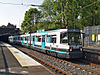
Drake Street Metrolink Station was a planned station in Phase 3b of the Manchester Metrolink, to be located in Rochdale between the Railway Station and the bus station. In March 2011 the plans were scrapped by the transport bosses who believed it would be too close to Rochdale Station and could serve as an efficiency saving to allow the construction of Kingsway Metrolink station[1]. However in August 2011, there was fresh hope for the stop, as long as the regeneration chiefs could find sufficient funding.
References
- ^ "Drake Street Metrolink stop comes to the end of the line". Rochdale Observer. http://menmedia.co.uk/rochdaleobserver/news/s/1410226_drake_street_metrolink_stop_comes_to_the_end_of_the_line. Retrieved 17 March 2011.
External links
- http://www.lrta.org/Manchester/Oldham_Rochdale.html
- Metrolink Stop at Drake Street set to be scrapped - Rochdale Observer
- Drake Street Metrolink stop comes to the end - Rochdale Observer
- http://menmedia.co.uk/rochdaleobserver/news/s/1454391_fresh-hope-for-axed-drake-street-metrolink-tram-stop
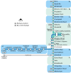
Preceding station  Manchester Metrolink
Following station ' towards VictoriaOldham and Rochdale Line Rochdale Town CentreTerminusRailways in Rochdale (Past, Present and Future) LegendTo Bacup 

To Calderdale Broadley 

Littleborough Shawclough and Healey 
Wardleworth Smithy Bridge 

Rochdale Town Centre 

Drake Street 


Rochdale 

Newbold 
Kingsway To Bury Milnrow Broadfield 
New Hey 
To Oldham Heywood 
Castleton 
Middleton 
Mills Hill 
To Manchester Manchester Metrolink
Manchester to Rochdale
line (proposed)LegendRochdale Town Centre Rochdale Railway Station Newbold Kingsway Business Park Milnrow Newhey Shaw and Crompton Derker Oldham Mumps Oldham Central Oldham King Street Westwood Freehold South Chadderton Hollinwood Failsworth Newton Heath and Moston Central Park Monsall Manchester Victoria to Piccadilly Coordinates: 53°36′47″N 2°09′18″W / 53.6131°N 2.1549°W
MetrolinkStations City zoneAltrincham LineAltrincham · Brooklands · Cornbrook · Dane Road · Navigation Road · Old Trafford · Sale · Stretford · Timperley · Trafford Bar
Bury LineAbraham Moss · Besses o'th' Barn · Bowker Vale · Bury · Crumpsall · Heaton Park · Prestwich · Radcliffe · Whitefield · Woodlands Road
Eccles LineAnchorage · Broadway · Eccles · Exchange Quay · Harbour City · Ladywell · Langworthy · MediaCityUK · Pomona · Salford Quays · Weaste
South Manchester LineChorlton · Firswood · St Werburgh's Road
Operations OperatorsStagecoach Group · Transport for Greater ManchesterVehiclesFlexity Swift M5000 · T-68History Former operatorsTransferred linesClosed stationsAbandoned plansUnder Construction Bury LineQueens Road
East Manchester LineAshton Moss · Ashton Under Lyne · Ashton West · Audenshaw · Cemetery Road · Clayton Hall · Droylsden · Eastlands City Stadium · Edge Lane · Holt Town · New Islington · Velopark
Oldham & Rochdale LineCentral Park · Derker · Failsworth · Freehold · Hollinwood · Kingsway · Monsall · Milnrow · Newbold · Newton Heath and Moston · Newhey · Oldham Central · Oldham King Street · Oldham Mumps · Rochdale railway station · Rochdale Town Centre · Shaw & Crompton · South Chadderton · Westwood
South Manchester LinesBaguley · Barlow Moor Rd. · Benchill · Burton Road · Crossacres · Didsbury · East Didsbury · Hardy Farm · Haveley · Hough End · Manchester Airport · Martinscroft · Moor Road · Northern Moor · Peel Hall · Robinswood Road · Roundthorn · Sale Water Park · Shadowmoss · West Didsbury · Withington · Woodhouse Park · Wythenshawe Town Centre · Wythenshawe Park
Proposed Bury LineBuckley Wells
Trafford Centre LineImperial War Museum · Lostock Parkway · Manchester United · Parkway Circle · Port Salford · Salford Reds · Trafford Centre · Trafford Quays · Village
Stockport LineGorsey Bank · Heaton Mersey · Kings Reach · Stockport Interchange
Second City CrossingExchange Square
Transport for Greater Manchester · UK light rail systemsCategories:- Proposed Manchester Metrolink stations
- Manchester Metrolink Rochdale-Manchester line stations
- Greater Manchester railway station stubs

Wikimedia Foundation. 2010.