- Mamburao, Occidental Mindoro
-
Mamburao
Bayan ng Mamburao— Municipality — 
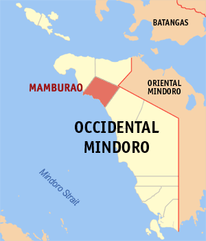
SealMap of Occidental Mindoro showing the location of Mamburao. Location in the Philippines
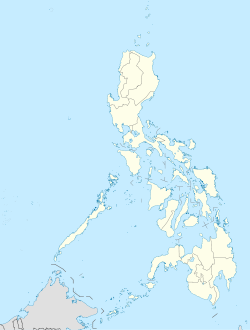
 Mamburao
Coordinates: 13°13.33′N 120°35.83′E / 13.22217°N 120.59717°ECoordinates: 13°13.33′N 120°35.83′E / 13.22217°N 120.59717°E Country  Philippines
Region MIMAROPA Province Occidental Mindoro District Lone District of Occidental Mindoro Founded 1955 Barangays 15 Government – Mayor Voltaire Anthony C. Villarosa Area – Total 339.50 km2 (131.1 sq mi) Population (2007) – Total 34,487 – Density 101.6/km2 (263.1/sq mi) Time zone PST (UTC+8) ZIP code 5106 Dialing code 43 Income class 2nd Class; Partially Urban Website mamburao.webtogo.com.ph Mamburao is a 2nd class municipality in the province of Occidental Mindoro, Philippines. It is the capital municipality of Occidental Mindoro. According to the 2007 census, it has a population of 34,487 people and has 20,344 registered voters (2010). The town has an approximate land area of 33,950 hectares.
Contents
Location
Mamburao is located on the northern part of Occidental Mindoro, which is the seat of the provincial government. Three (3) – neighboring towns bounded the municipal area, on the west is the town Paluan, on the north is Abra de Ilog and on the southeast is the municipality of Sta. Cruz. It is about 170 kilometers from San Jose, the southern town of Occidental Mindoro within the Island.
The National Highway is passing thru the heart of the town via Abra de Ilog going to Oriental Mindoro. The rest is going to Paluan and Sta. Cruz.
The municipality of Mamburao can be connected in the mainland like Manila and other of Luzon provinces by air and water transportation. Mamburao is accessible by water transportation thru its port at Barangay Tayamaan where big vessels are anchored and Matabang Port located at Abra de Ilog, Occidental Mindoro.
Topography
A Flat terrain characterized topography of the land and rolling land, the inner portion is mountainous. Mamburao River is the largest and longest river that surrounds the poblacion area. It has its mouth on the northern side of Barangay Balansay and on the Southern side of Barangay Tayamaan. The rivers that traverse the area are the Tuguilan, Sug-sugin, Maculbo and Talabaan River. There are also four creeks that pass the different barangays which include Baboy creek and Igsu creek.
History
The first settlement in Mindoro to have been visited by the Spaniards was the village of Mamburao, which according to accepted history made this village the Moro stronghold in the island. Early on January 1, 1560, Legaspi dispatched his grandson Juan de Salcedo with a combined Panay Forces in 15 boats, sailed from Mamburao and destroyed this Mohammedan town and demolished the pirate port. Salcedo returned richly laden with spoils of war and covered with martial glory. On May 3, 1560, another expedition was sent from Panay which included Salcedo and Martin de Goiti and touched at Mamburao.
In the early days of the propagation of Christianity, the Village of Mamburao belonged to the third convent district established at Calavite. Mamburao later became a ‘colossal empire”, for it either incorporated three towns or gave birth to the municipality. From the end of the Spanish period in 1902, Sablayan was a barrio of Mamburao as barrios. Under Act 1280 in 1905, Paluan and Abra de Ilog were annexed to Mamburao as barrios. All these places however, eventually were created as separate municipalities, In 1929, Sta. Cruz, a barrio of Mamburao, was also given independent status as a municipality.
Before the separation of Sta. Cruz from Mamburao, the latter had an area of 1,050 square kilometers, or 105,000 hectares. The population of Mamburao in 1903 was only 894, in 1939, it increased at 4,423, and in 1948 it jumped to 5,571. Literacy percentage then was 46.6%.
Mamburao’s population at the turn of the century was very sparse because it was depopulated during the Muslim invasion and piracy in the seventeenth and eighteenth centuries. Mamburao itself was made the base of Muslim piratical raids of the coastal towns of Mindoro, Luzon and Visayas. During the latter part of the nineteenth century, Mamburao was peopled again by immigrants. The first batch if immigrants were Ilocanos who came from Zambales. Among the pioneering settlers were Simon Agpalo, Juan Ladao and Hermogenes Alcaide. Agpalo came in with his relatives, the de Jesuses, the Regudos and Ladaos. Simon Agpalo settled in Mamburao in 1860. At the turn of the century, Tagalogs came to Mamburao. Most of them came from Lubang, Looc, and Paluan, but some came from Batangas and Cavite.
By June 13, 1950, the entire province of Mindoro was divided into two Oriental and Occidental Mindoro, with Mamburao chosen as capital for Occidental Mindoro. The capital of Occidental Mindoro can be reached from the north via Batangas City to Matabang Port at Abra de Ilog – and on the South entrance thru Caminawit Port- San Jose approximately 32 and 170 kilometers distance respectively through national highways.
In the year 1974, Poblacion was divided into eight (8) barangays. In October, 1972 under Presidential Decree No. 86, there ware Barnagays Poblacion 1,2,3,4,5,6,7, and 8. The barangays were headed by the barangay Chairman and six (6) councilmen duly elected by the assembly.
On May 17, 1997, Barangay election was held. The total reorganization of Barangay Officials was undertaken headed by the Punong Barangay ad six (6) Kagawads. In the recently held 1997 Barangay Elections, the composition of barangay officials includes the Punong Barangay, seven (7) Barangay Councilors and one (1) Sangguniang Kabataan Chairman as Ex-Officio Kagawad.
Presently, Mamburao is composed of Fifteen (15) Barangays, with an approximate land area of 33,950 hectares.
Climate
Generally, the climate of Mamburao is tropical and invigorating varies according to the elevation of the locality. At the vicinity of Mamburao Bay, it is relatively cool because of sea breezes and from the mountains and forest areas makes the climate of the town mild and healthful/
The municipality has two pronounced seasons. The dry from November to April and wet from May to October. Temperature and humidity are uniformly high with little seasonal variations. The typhoon usually occurs in the month of August to November and the area is sometime flooded.
The southeast monsoon prevails in the month of June to September and northeast monsoon in the month of December to February. The winds are available ranging from 15–30 km/h. The temperature is relatively high and the most humid occurs from July to October while least is the month of April.
Barangays
Mamburao is politically subdivided into 15 barangays. The eight (8) barangays are found in the population created under P.D. 86 and the seven (7) are outside the poblacion area.
Barangay Urban/Rural Population* Balansay Rural 5,547 Fatima (Tii) Rural 1,449 Payompon Urban 9,822 San Luis (Ligang) Rural 897 Talabaan Rural 2,010 Tayamaan Rural 1,913 Talabaan Rural 5,681 Poblacion 1 (Barangay 1) Urban 313 Poblacion 2 (Barangay 2) Urban 1,878 Poblacion 3 (Barangay 3) Rural 227 Poblacion 4 (Barangay 4) Rural 746 Poblacion 5 (Barangay 5) Rural 434 Poblacion 6 (Barangay 6) Rural 607 Poblacion 7 (Barangay 7) Urban 1,975 Poblacion 8 (Barangay 8) Urban 988 *As of Aug 1, 2007
Government officials
From May 2010 to May 2013:
- Mayor: Voltaire Anthony C. Villarosa
- Vice Mayor: Angelina F. Tria
- Sangguniang Bayan:
- Nene Castillo-Villar
- Noli Olfato
- Dulce Recaido
- Donjie Cosuco
- Alberto Alastre
- Boy Masangkay
- Ver Cascalla
- Les Calabio
Ex-Officio Members:
- ABC President: Meliton Benasas
- SK Federation President: Jenny Villar
External links
Municipalities Abra de Ilog • Calintaan • Looc • Lubang • Magsaysay • Mamburao • Paluan • Rizal • Sablayan • San Jose • Santa CruzCategories:- Municipalities of Occidental Mindoro


Wikimedia Foundation. 2010.