- Westmorland
-
This article is about the English county. For other uses, see Westmoreland (disambiguation).
Westmorland 
Ancient extent of WestmorlandGeography Status Administrative county (1889-1974)
Ceremonial county (until 1974)1831 area 485,990 acres (1,966.7 km2)[1] 1911 area 505,330 acres (2,045.0 km2)[2] 1961 area 504,917 acres (2,043.33 km2)[2] HQ Appleby (historic county town)
County Hall, Kendal (1889-1974)Chapman code WES History Origin Historic Created In antiquity Succeeded by Cumbria Demography 1911 population 63,575[2] 1961 population 67,180[2] Politics Governance Westmorland County Council (1889-1974) 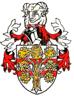
Arms of Westmorland County CouncilSubdivisions Type Baronies, Wards (ancient) Westmorland (
 /ˈwɛstmərlənd/; formerly also spelt Westmoreland[3], an even older spelling is Westmerland or Westmereland) is an area of North West England and one of the 39 historic counties of England. It formed an administrative county from 1889 to 1974, after which the entirety of the county was absorbed into the new county of Cumbria.
Contents
Early history
At the time of Domesday Book in 1086, parts of the county were considered either to form part of Yorkshire or to be within the separate kingdom of Scotland, having historically been associated with the Kingdom of Strathclyde. The Normans conquered the area that is now Cumbria in 1092 during the reign of William II and created the baronies of Kendal and Westmorland. These were originally distinct jurisdictions with separate sheriffs, but were formed into a single county of Westmorland in 1226/7.[4] Before 1226 the Barony of Kendal was connected to the Earldom or Honour of Lancaster while that of Westmorland was part of the Earldom of Carlisle.
The historic county boundaries are with Cumberland to the north, County Durham and Yorkshire to the east, and Lancashire to the south and west. Windermere forms part of the western border with Lancashire north of the sands, and Ullswater part of the border with Cumberland.
The highest point of the county is Helvellyn at 950m (3,117 ft). According to the 1831 census the county covered an area of 485,990 acres (1,966.7 km2).[1]
Appleby, the historic county town, formed a historic borough and was unreformed by the Municipal Corporations Act 1835; although reform came later in 1885. Kendal was reformed as a municipal borough in 1835.
Division into wards
Rather than being divided into hundreds, Westmorland was subdivided into two baronies of Westmorland (or sometimes Appleby) and Kendal.
The baronies were further subdivided into two wards each:
- Westmorland
- Kendal
- Kendal ward [7] - Ambleside, Burton-in-Kendal, Grasmere, Grayrigg, Kentmere, Kendal, Windermere
- Lonsdale ward [8] - Kirkby Lonsdale
Modern history
In 1889, under the Local Government Act 1888, a county council was created for Westmorland, taking functions from the Quarter Sessions. Westmorland had no county boroughs throughout its history, so the administrative county, the area under the control of the county council, was coterminous with the geographic county. The county council was based at Kendal, rather than the historic county town of Appleby-in-Westmorland.
Aside from the two municipal boroughs of Kendal and Appleby, the Local Government Act 1894 divided the county into urban districts and rural districts.
- 5 Urban districts: Ambleside, Bowness on Windermere, Grasmere, Kirkby Lonsdale, Windermere
- 3 Rural districts: West Ward, East Westmorland, South Westmorland
In 1905 a new Shap urban district was formed, while Windermere absorbed the neighbouring Bowness UD.
A County Review Order in 1935 reduced the number of districts in the county:
- A new Lakes Urban District was formed by the merger of Ambleside and Grasmere UDs and adjacent parishes in West Ward and South Westmorland RDs
- East Westmorland RD, most of West Ward RD and Shap UD were merged to form North Westmorland Rural District
- South Westmorland RD absorbed Kirkby Lonsdale UD, at the same time losing an area to Lakes UD.[4]
Despite their title, many of Westmorland's urban districts, such as Lakes, Grasmere, and Shap, were quite rural in character.
According to the 1971 census, Westmorland was the second least populated administrative county in England, after Rutland. The distribution of population was as follows:[9]
District Population Municipal Borough of Appleby 1,944 Municipal Borough of Kendal 21,602 Lakes Urban District 5,815 Windermere Urban District 8,065 North Westmorland Rural District 14,778 South Westmorland Rural District 20,633 In 1974, under the Local Government Act 1972, the county council was abolished and its former area was combined with Cumberland and parts of Lancashire and Yorkshire to form the new county of Cumbria, administered by a new Cumbria County Council. The area now forms parts of the districts of South Lakeland and Eden.
Coat of arms
Westmorland County Council was granted a coat of arms by the College of Arms in 1926. The design of the shield referred to the two components of the county: on two red bars (from the arms of the de Lancaster family, Barons of Kendal) was placed a gold apple tree (from the seal of the borough of Appleby, for the Barony of Westmorland). The crest above the shield was the head of a ram of the local Herdwick breed. On the ram's forehead was a shearman's hook, a tool used in the handling of wool. The hook was part of the insignia of the borough of Kendal, the administrative centre of the county council.[10]
Legacy
 Map of Westmorland, 1824
Westmorland is still used as a place name by organisations and businesses in the area such as:
- The Westmorland Gazette (founded 1818)
- The Westmorland County Agricultural Society (founded 1799), which organises the annual Westmorland County Agricultural Society Show
- The Westmorland Geological Society (formed 1973)
- The Cumberland and Westmorland Antiquarian and Archaeological Society (founded 1866)
- The Westmorland Youth Orchestra
- The Westmorland Shopping Centre, Kendal
- The Westmorland Cricket League
- Westmorland services, better known as Tebay services, on the M6 motorway.
- In 1974 the successor parish council formed for the former borough of Appleby adopted the name Appleby-in-Westmorland.
- Westmorland General Hospital in Kendal
- Westmorland croquet club
The southern part of the county, the former Barony of Kendal or that part of Westmorland that is part of South Lakeland, is included in the Westmorland and Lonsdale parliamentary constituency.
 Flag of Westmorland
In June 1994, during the 1990s UK local government reform, the Local Government Commission published draft recommendations suggesting that Westmorland's border with Yorkshire and Lancashire be restored for ceremonial purposes. The final recommendations, published in October 1994, did not include such recommendations, apparently due to lack of expression of support for the proposal to the commission.
In September 2011, the Westmorland Association, a local society which promotes the county's identity successfully registered the Flag of Westmorland with the Flag Institute.
Notable people
- Thomas Strickland Esq carried the Flag of St. George at the battle of Agincourt.
- St. John Boste, Roman Catholic priest and martyr
- The Claybourn family (with some variations in the name) originated in Westmorland and share their name with the small Westmorland village of Cliburn, which is located six miles (10 km) southeast of the town of Penrith. Some have estimated that this family which originated in Westmorland now numbers in the millions.[11]
See also
References
- ^ a b 1831 Census cited in Vision of Britain - Ancient county data
- ^ a b c d Vision of Britain - Westmorland population (density and area)
- ^ R. Wilkinson The British Isles, Sheet The British Isles. Vision of Britain
- ^ a b F.A. Youngs, Guide to the Local Administrative units of England, Vol.II, Northern England, London, 1991
- ^ Vision of Britain - History of East ward
- ^ Vision of Britain - History of West ward
- ^ Vision of Britain - History of Kendal ward
- ^ Vision of Britain - History of Lonsdale ward
- ^ 1971 Census; Small Area Statistics
- ^ W.C. Scott-Giles, Civic Heraldry of England and Wales, 2nd edition, London, 1953
- ^ Bissell, Lolita Hannah. "Cliborn-Claiborne Records" (Nashville, 1986). See also The Descendants of James Monroe Sills, James Cliburn & Allied Pitman Family by Isom L. Stephens (1972), wherein the author estimates that 'John of Dale Parish' had upward of a million descendants living in the United States in 1972.
External links
Bedfordshire · Berkshire · Buckinghamshire · Cambridgeshire, Isle of Ely · Cambridgeshire and Isle of Ely · Cheshire · Cornwall · Cumberland · Derbyshire · Devon · Dorset · Durham · Essex · Gloucestershire · Hampshire · Herefordshire · Hertfordshire · Huntingdonshire · Huntingdon and Peterborough · Kent · Lancashire · Leicestershire · Lincolnshire: Parts of Holland, Parts of Kesteven, Parts of Lindsey · London · Middlesex · Norfolk · Northamptonshire, Soke of Peterborough · Northumberland · Nottinghamshire · Oxfordshire · Rutland · Shropshire · Somerset · Staffordshire · Suffolk: East Suffolk, West Suffolk · Surrey · Sussex: East Sussex, West Sussex · Warwickshire · Westmorland · Wiltshire · Worcestershire · Yorkshire: East Riding, North Riding, West Riding
Bedfordshire · Berkshire · Buckinghamshire · Cambridgeshire · Cheshire · Cornwall · Cumberland · Derbyshire · Devon · Dorset · Durham · Essex · Gloucestershire · Hampshire · Herefordshire · Hertfordshire · Huntingdonshire · Isle of Ely · Kent · Lancashire · Leicestershire · Lincolnshire · Middlesex · Norfolk · Northamptonshire · Northumberland · Nottinghamshire · Oxfordshire · Rutland · Shropshire · Somerset · Staffordshire · Suffolk · Surrey · Sussex · Warwickshire · Westmorland · Wiltshire · Worcestershire · Yorkshire
Categories:- Westmorland
- History of Cumbria
- Geography of Cumbria
- Counties of England established in antiquity
- Counties of England disestablished in 1974


Wikimedia Foundation. 2010.