- Opa-locka Airport
-
Opa-locka Airport
Opa-locka Executive AirportIATA: OPF – ICAO: KOPF – FAA LID: OPF Summary Airport type Public Owner Miami-Dade County Operator Miami-Dade Aviation Department (MDAD) Serves Miami, Florida Location Dade County, Florida Elevation AMSL 8 ft / 2 m Coordinates 25°54′25″N 080°16′42″W / 25.90694°N 80.27833°W Website Runways Direction Length Surface ft m 9L/27R 8,002 2,439 Asphalt 9R/27L 4,306 1,312 Asphalt 12/30 6,800 2,073 Asphalt Statistics (2001) Aircraft operations 149,813 Based aircraft 291 Source: Federal Aviation Administration[1] Opa-locka Airport (IATA: OPF, ICAO: KOPF, FAA LID: OPF), also known as Opa-locka Executive Airport, is a general aviation airport and joint civil-military airfield 10 miles (16 km) north of Downtown Miami, primarily in metropolitan Miami, Florida, United States, with a portion within the city proper of Opa-locka.[1][2]
The airport's control tower is manned from 7:00 AM to 9:00 PM. The airport has four fixed base operators. It is owned by Miami-Dade County and operated by the Miami-Dade Aviation Department.[3]
The tenant military activity is Coast Guard Air Station Miami, operating HU-25 Guardian jet aircraft, the HC-144 Ocean Sentry[4] turboprop aircraft and HH-65 Dolphin helicopters for coastal patrol and air-sea rescue operations. Much of CGAS Miami's facilities were originally built during World War II as part of the former Naval Air Station Miami.
DayJet previously provided an on-demand jet air taxi service from this airport to 44 airports in 5 states. The company filed for Chapter 7 bankruptcy liquidation in 2008.
The airport is currently served by several cargo and charter airlines who use the U.S. customs facility. Maintenance and modification of airliners up to Boeing 747 size is carried out by several aviation firms.
Contents
History
Aviation pioneer Glenn Curtiss retired from aircraft development and manufacturing in the 1920s and became a real estate developer in Florida. In 1926 he founded the City of Opa-locka, naming it Opa-tisha-woka-locka (quickly shortened to Opa-locka), a Native American name that translates into the high land north of the little river on which there is a camping place.
In late 1925 he moved the Florida Aviation Camp from Hialeah to a parcel west of the city. This small airfield was surrounded by the Opa-locka Golf Course. In 1929 he transferred this land to the City of Miami, and the city erected on it a World War I surplus hangar from Key West. This field became known as the Municipal Blimp Hangar. The following year, the Goodyear Blimp started operations out of this hangar.
In 1928 Curtiss made a separate donation of land south of Opa-locka for Miami's first Municipal Airport.The Curtiss Aviation School later moved from Biscayne Bay to this airport. In 1937 Amelia Earhart started her attempt to circumnavigate the world from this airport.[5][6] A larger area to the east of Miami Municipal Airport was developed during the 1930s as All-American Airport. The All-American Airport was acquired by the City of Miami around 1938 and on this land the city of Miami built the first "Miami International (Master) Airport".[7]
After Curtiss died in 1930 his estate transferred a parcel of land north of the golf course and the Florida Aviation Camp to the city of Miami. The city then leased it to the United States Navy. Curtiss had been lobbying for the establishment of the Naval Reserve Base in Miami since 1928. This property became a Naval Reserve Aviation Training Base (NRATB).
In 1932 the U.S. Navy leased from the city of Miami what is today the west half of Opa-locka airport. On this land the Navy erected a dirigible mooring mast. The dirigible USS Akron stopped at what at this mast on both legs of its 1933 trip to the Panama Canal Zone, and departed the station less than two weeks before its fatal crash in April 1933. The base was one of the stops on the triangular Germany-Brazil-United States-Germany route of the Graf Zeppelin[8]. Major expansion of the base began in 1939, and it was commissioned as Naval Air Station Miami (NAS Miami) in 1940.
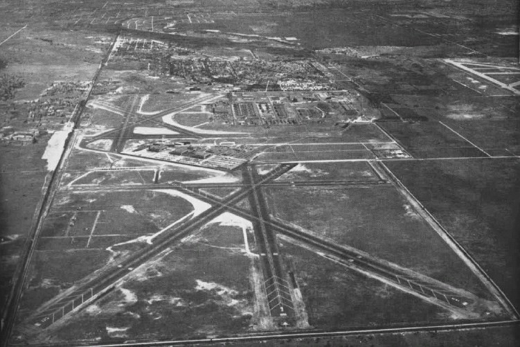
 Aerial view of NAS Miami in the mid-1940s
The Naval Reserve Air Base, the Municipal Blimp Hangar, the U.S. Navy's Dirigible Mooring Mast, the city of Miami's Municipal Airport and the All-American Airport existed as separate facilities until their land became incorporated into NAS, Miami.
Miami Municipal Airport and Miami International (Master) Airport were purchased from the city by the federal government in 1942 and added to Naval Air Station Miami (NAS Miami) as Miami Municipal Field and Master Field (later referred to colloquially as "Masters Field"), respectively. Miami Municipal Field was connected to Masters Field by a taxiway that crossed the railroad tracks which separated the two fields. Miami Municipal Field was renamed Amelia Earhart Field in 1947.[9] The All-American Air Races were held at Miami Municipal/Amelia Earhart Field or All-American Airport/Miami International (Master) Airport from 1929 until 1935, and the All-American Air Maneuvers from 1935 until 1941 and from 1946 to 1950.[7][10]
During World War II, NAS Miami was headquarters for operations of the U.S. Naval Air Training Command, with six training bases.[6] NAS Miami consisted of the original training base, known as Mainside or Opa-Locka, Miami Municipal Field and Master Field. At its peak, the base employed 7,200 officers and men and 3,100 civilians.[9] Activity continued on a reduced basis after the war.
Following the departure of U.S. Navy, but retention of U.S. Marine Corps Reserve flying and aviation support units, Master Field became Marine Corps Air Station Miami (MCAS Miami) circa 1955.[11]. With the transfer of Marine Air Reserve squadrons and support units to NAS Jacksonville, Florida in 1958 and 1959, MCAS Miami was marked for closure and the air station closed as a Department of the Navy installation in 1959. Former military property was transferred to Dade County and the Dade County Junior College opened on the site in 1961.
In 1962 the remainder of the former NAS Miami property, except for a portion reserved for the United States Coast Guard, was transferred to Dade County, and became Opa-locka Airport. In 1965 Coast Guard Air Station Miami transferred its aircraft and operations from its Dinner Key installation to the Opa-locka Airport, re-establishing CGAS Miami on site. CGAS Miami continues to operate on site with HU-25 Guardian and HC-144 Ocean Sentry fixed-wing aircraft and HH-65 Dolphin helicopters.
For the year 1963 Opa-locka was the 42nd busiest civil airport in the country by total operations count. In 1964 it was #18, in 1965 #3, and in 1966 and 1967 it was #2 behind O'Hare. In 1971 it was down to #17.
Some of the 9/11 hijackers trained at the airport.[12]
Facilities and aircraft
Opa-locka Airport covers an area of 1,810 acres (730 ha) which contains three asphalt paved runways: 9L/27R measuring 8,002 x 150 ft (2,439 x 46 m), 9R/27L measuring 4,306 x 100 ft (1,312 x 30 m) and 12/30 measuring 6,800 x 150 ft (2,073 x 46 m).[1]
Fire protection at the airport is provided by Miami-Dade Fire Rescue Department Station 25.[13][14]
For the 12-month period ending December 31, 2001, the airport had 149,813 aircraft operations, an average of 410 per day: 83% general aviation, 11% military, 5% air taxi and <1% scheduled commercial. At that time there were are 291 aircraft based at this airport: 40% single-engine, 36% multi-engine, 11% jet, 7% helicopter and 6% military.[1]
Accidents and incidents
- In 1970, Douglas C-49K N12978 of Air Carrier was damaged beyond economic repair when it caught fire.[15]
- On 21 January 1982, Douglas DC-3A N211TA of Tursair was substantially damaged in an accident. The aircraft was on a training flight and the trainee pilot mishandled the engine controls, causing a temporary loss of power. The aircraft ran off the runway and collided with a tree.[16] Inadequate supervision and the failure of the student pilot to relinquish control of the aircraft to the instructor were cited as contributing to the accident.[17]
References
- ^ a b c d FAA Airport Master Record for OPF (Form 5010 PDF), effective 2007-10-25
- ^ "Opa-locka city, Florida." U.S. Census Bureau. Retrieved on January 9, 2010.
- ^ Official Opa-locka Airport site - URL retrieved April 8, 2006
- ^ http://coastguard.dodlive.mil/index.php/2010/10/air-station-miami-welcomes-the-ocean-sentry/
- ^ Official Opa-locka Airport site
- ^ a b La Floridiana - Opa-Locka Field - URL retrieved August 16, 2006
- ^ a b Abandoned & Little-Known Airfields: Florida - Northern Miami Area - All American Field / Master Airport - URL retrieved August 16, 2006
- ^ Miller, Alicia Momsen. From Rio to Akron aboard the Graf Zeppelin, 1933: A flight aboard a dirigible, as seen through the eyes of an eight year old girl. - URL retrieved April 8, 2006
- ^ a b Florida's World War II Memorial - NAS Miami Opa-Locka Airport - URL retrieved August 16, 2006
- ^ ALL THE WORLD’S AIR RACES - URL retrieved August 16, 2006
- ^ History of Marine fighter squadron stationed at Marine Corps Air Station Miami - URL retrieved April 8, 2006
- ^ Context of 'December 29-31, 2000: Atta and Alshehhi Train on Flight Simulator; Uncertainty over Whether They Gain Skills Needed for 9/11 Attacks'
- ^ "Airport Fire Rescue Division". Miami-Dade Fire Rescue Department. Miami-Dade County. http://www.miamidade.gov/mdfr/airport.asp. Retrieved August 30, 2006.[dead link]
- ^ "Miami-Dade Fire Rescue Stations". Miami-Dade Fire Rescue Department. Miami-Dade County. http://www.miamidade.gov/MDFR/stations_units.asp. Retrieved August 30, 2006.[dead link]
- ^ "N12978 Hull-loss description". Aviation Safety Network. http://aviation-safety.net/database/record.php?id=19709999-2. Retrieved 20 October 2010.
- ^ "N211TA Accident report". Aviation Safety Network. http://aviation-safety.net/database/record.php?id=19820121-0. Retrieved 9 July 2010.
- ^ "NTSB Identification: MIA82FA037". National Transportation Safety Board. https://www.ntsb.gov/ntsb/brief.asp?ev_id=20020917X02399&key=1. Retrieved 23 July 2010.
External links
- Opa-locka Executive Airport (official site)
- Opa-locka AirportPDF (414 KiB) brochure from CFASPP (June 2007)
- FAA Airport Diagram (PDF), effective 20 October 2011
- FAA Terminal Procedures for OPF, effective 20 October 2011
- Resources for this airport:
- AirNav airport information for KOPF
- ASN accident history for OPF
- FlightAware airport information and live flight tracker
- NOAA/NWS latest weather observations
- SkyVector aeronautical chart, Terminal Procedures for KOPF
South Florida metropolitan area Largest city Counties
(by population)Cities and towns
100k-250kCities and towns
25k-99kAventura • Boca Raton • Boynton Beach • Coconut Creek • Cooper City • Coral Gables • Dania Beach • Davie • Deerfield Beach • Delray Beach • Doral • Greenacres • Hallandale Beach • Homestead • Jupiter • Lake Worth • Lauderdale Lakes • Lauderhill • Margate • Miami Beach • North Lauderdale • North Miami • North Miami Beach • Oakland Park • Palm Beach Gardens • Plantation • Riviera Beach • Sunrise • Tamarac • West Park • Weston • Wilton ManorsCities and towns
10k-25kA list of cities under 10,000 is available here. Categories:- Airports in Miami-Dade County, Florida
- Airports established in 1925
- United States Coast Guard Aviation
- Opa-locka, Florida
Wikimedia Foundation. 2010.