- St. Johns River Light
-
Not to be confused with St. Johns Light.
St. Johns River Light 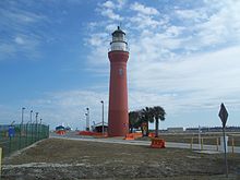
St. Johns River lighthouse Location Near the mouth of the St. Johns River on the property of Naval Station Mayport Coordinates 30°23′36.77″N 81°25′33.49″W / 30.3935472°N 81.4259694°W Year first lit 1858 Deactivated 1929 Foundation Natural / Emplaced Construction Brick Tower shape Conical tower Height 81 ft Original lens Third order Fresnel lens The St. Johns River Light is a decommissioned lighthouse in Jacksonville, Florida, U.S., which formerly marked the mouth of the St. Johns River. It is located on the grounds of Naval Station Mayport in the Mayport area. Constructed in 1858, it was decommissioned in 1929 and replaced with a lightship. It is sometimes known as the "Old St. Johns River Light" to distinguish it from the modern St. Johns Light, built in 1954.
The Old St. Johns River Light was the third lighthouse to be erected at the mouth of the St. Johns. It is the oldest one still standing, and is in fact the oldest surviving building in Mayport. It was added to the National Register of Historic Places in 1976 and underwent restoration in 1980.
Contents
History
The St. Johns River Light was erected in 1858 at Mayport, on what is now the property of Naval Station Mayport. It was the third lighthouse to stand at the mouth of the St. Johns River, and was designed specifically to overcome the previous structures' problems with visibility and erosion. The first St. Johns lighthouse was erected in 1830, after the U.S. purchase of Florida, and was funded by the U.S. Congress. However, it was built too close to the water and had to be demolished only three years later. The second lighthouse was erected in 1835, about a mile upriver. However, view of the light from sea was often blocked by shifting sand dunes, and by 1853 its foundation was so disturbed by erosion that plans were made to replace it. This structure was soon abandoned and enveloped by the river, though its ruins could still be seen in the early 20th century.[1]
The present St. Johns River Light was erected in 1858. In order to avoid its predecessors' problems, it was made substantially taller and further from the waterline. During the American Civil War a Confederate sympathizer shot out the light to hamper Union ships attempting to locate the river. It was finally replaced on July 4, 1867.[2] In 1887 authorities planned to heighten the tower another twelve feet. A study in the 20th century determined that this plan was never carried out, though the light station canopy was remodeled, and the present copper cupola was installed.[1]
In 1929, the St. Johns River Light was decommissioned after over 70 years of service. It was replaced by the St. Johns Lightship (LV-84), moored about 8 miles offshore from the river's mouth.[1][2] In the 1940s the U.S. Navy acquired most of Mayport, including the area around the lighthouse, in order to establish Naval Station Mayport. The Navy demolished an attached one-story building and raised the grade of the surrounding land by about seven feet. As such the original door is buried and the tower is only accessible via a window eight feet off the ground.[1] In 1954 the modern St. Johns Light was built to replace the lightship; it is located about two miles southeast of the Old St. Johns River Light.[2][3]
The Old St. Johns River Light was added to the National Register of Historic Places in 1976.[4] It is the oldest surviving building in Mayport, and was designated one most significant historic buildings in Jacksonville by the Jacksonville Historic Landmarks Commission.[1] In 1980 it underwent restoration by Shepard Associates. It currently stands at 85 feet tall, with a red brick tower, slate stairs and balcony, and a white watch room topped by a copper cupola.[1] A local group, the Mayport Lighthouse Association, hope to undertake a full restoration and open the structure to the public.[5]
Notes
- ^ a b c d e f Wood, p. 326.
- ^ a b c "Historic Light Station Information and Photography: Florida". United States Coast Guard Historian's Office. http://www.uscg.mil/history/weblighthouses/LHFL.asp.
- ^ "Inventory of Historic Light Stations: Florida Lighthouses" (March 05, 2002). National Park Service. Retrieved October 5, 2010.
- ^ Duval County listings at National Register of Historic Places. Retrieved January 28, 2011
- ^ Rowlett, Russ (2010-03-11). "Lighthouses of the United States: Eastern Florida and the Keys". The Lighthouse Directory. University of North Carolina at Chapel Hill. http://www.unc.edu/~rowlett/lighthouse/fl.htm.
References
- Wood, Wayne W.; Jacksonville Historic Preservation Commission (1996). Jacksonville's Architectural Heritage. University Press of Florida. ISBN 9780813009537.
External links
 Media related to St. Johns River Light at Wikimedia Commons
Lighthouses of Florida See also: List of operating lighthouses in FloridaAlligator Reef • Amelia Island • Amelia Island North Range • American Shoal • Anclote Keys • Cape Canaveral • Cape Florida • Cape San Blas • Cape St. George • Carysfort Reef • Cedar Key • Charlotte Harbor • Crooked River • Dames Point • Dog Island • Dry Tortugas • Egmont Key • Fowey Rocks • Garden Key • Gasparilla Island • Hillsboro Inlet • Jupiter Inlet • Key West • Northwest Passage • Pensacola • Ponce de Leon Inlet • Rebecca Shoal • Sand Key • Sanibel Island • Sombrero Key • St. Augustine • St Johns • St. Johns River • St. Joseph Point • St. Marks • Unmanned reef lights of the Florida Keys • Volusia Bar Categories:
- Buildings and structures completed in 1858
- History of Jacksonville, Florida
- Lighthouses in Duval County, Florida
- National Register of Historic Places in Duval County, Florida


Wikimedia Foundation. 2010.