- Charlotte Harbor Light
-
Charlotte Harbor Light 
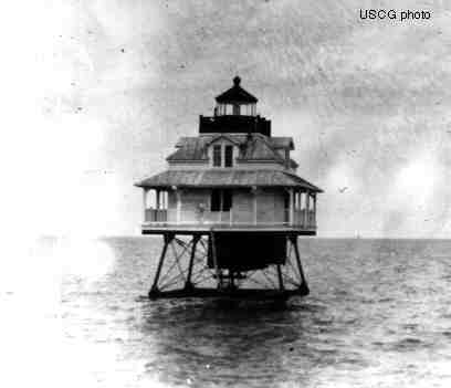
The Charlotte Harbor lighthouse (from U.S. Coast Guard archives) Location Charlotte Harbor, on the channel to Punta Gorda, Florida Coordinates Est.26°46′33″N 82°8′31″W / 26.77583°N 82.14194°W Year first lit 1890 Automated 1918 Deactivated 1943 Foundation iron pilings Construction wood Tower shape square house Original lens fifth-order Fresnel lens The Charlotte Harbor Light was placed at a bend in the deeper part of Charlotte Harbor to guide ships to the railroad docks in Punta Gorda, Florida. Punta Gorda lost importance as a port when railroad lines reached Boca Grande on the southern end of Gasparilla Island at the entrance to Charlotte Harbor in 1906. The lighthouse steadily deteriorated and had to be demolished in 1943. The iron pilings were removed in 1975.
References
- Charlotte Harbor Lighthouse History - accessed June 29, 2008
- "Historic Light Station Information and Photography: Florida". United States Coast Guard Historian's Office. http://www.uscg.mil/history/weblighthouses/LHFL.asp.
Lighthouses of Florida See also: List of operating lighthouses in Florida Alligator Reef • Amelia Island • Amelia Island North Range • American Shoal • Anclote Keys • Cape Canaveral • Cape Florida • Cape San Blas • Cape St. George • Carysfort Reef • Cedar Key • Charlotte Harbor • Crooked River • Dames Point • Dog Island • Dry Tortugas • Egmont Key • Fowey Rocks • Garden Key • Gasparilla Island • Hillsboro Inlet • Jupiter Inlet • Key West • Northwest Passage • Pensacola • Ponce de Leon Inlet • Rebecca Shoal • Sand Key • Sanibel Island • Sombrero Key • St. Augustine • St Johns • St. Johns River • St. Joseph Point • St. Marks • Unmanned reef lights of the Florida Keys • Volusia Bar Categories:
- Lighthouses in Florida
- United States lighthouse stubs
- Florida building and structure stubs

Wikimedia Foundation. 2010.