- Oost Gelre
-
Oost Gelre 
Flag
Coat of arms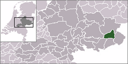
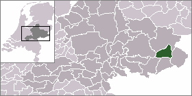
Coordinates: 52°00′N 6°34′E / 52°N 6.567°ECoordinates: 52°00′N 6°34′E / 52°N 6.567°E Country Kingdom of the Netherlands Constituent country  Netherlands
Province Gelderland AreaSource: Statistics Netherlands - Total 110.19 km2 (42.5 sq mi) - Land 109.70 km2 (42.4 sq mi) - Water 0.49 km2 (0.2 sq mi) Population (2005) - Total 29,811 - Density 359/km2 (929.8/sq mi) Time zone CET (UTC+1) - Summer (DST) CEST (UTC+2) Website www.oostgelre.nl Oost Gelre is a municipality in the Achterhoek, in the eastern Netherlands. On January 1, 2005, the municipalities Groenlo and Lichtenvoorde merged and formed the new municipality Oost Gelre, which was called Groenlo until May 19, 2006.
Population centres
- Eefsele
- Groenlo
- Harreveld
- Lichtenvoorde
- Lievelde
- Mariënvelde
- Vragender
- Zieuwent
- Zwolle (Gelderland)
External links
Aalten · Apeldoorn · Arnhem · Barneveld · Berkelland · Beuningen · Brummen · Bronckhorst · Buren · Culemborg · Doesburg · Doetinchem · Druten · Duiven · Ede · Elburg · Epe · Ermelo · Geldermalsen · Groesbeek · Harderwijk · Hattem · Heerde · Heumen · Lingewaal · Lingewaard · Lochem · Maasdriel · Millingen aan de Rijn · Montferland · Neder-Betuwe · Neerijnen · Nijkerk · Nijmegen · Nunspeet · Oldebroek · Oost Gelre · Oude IJsselstreek · Overbetuwe · Putten · Renkum · Rheden · Rijnwaarden · Rozendaal · Scherpenzeel · Tiel · Ubbergen · Voorst · Wageningen · West Maas en Waal · Westervoort · Wijchen · Winterswijk · Zaltbommel · Zevenaar · Zutphen

See also: Netherlands · Provinces · Municipalities Categories:- Oost Gelre
- Gelderland geography stubs


Wikimedia Foundation. 2010.