- Mundarlo, New South Wales
-
Mundarlo
New South Wales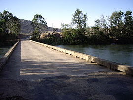
Mundarlo - Murrumbidgee River crossing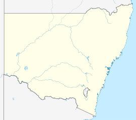
 Mundarlo
Population: 218 (2006 Census)[1] Postcode: 2729 Coordinates: 35°4′40″S 147°50′39″E / 35.07778°S 147.84417°ECoordinates: 35°4′40″S 147°50′39″E / 35.07778°S 147.84417°E Elevation: 303 m (994 ft) Location: - 13 km (8 mi) from Wantabadgery
- 18 km (11 mi) from Tumblong
LGA: City of Wagga Wagga County: Wynyard State District: Burrinjuck Mundarlo is a farming community in the central east part of the Riverina and situated about 13 kilometres south east from Wantabadgery and 18 kilometres north west from Tumblong. At the 2006 census, Mundarlo had a population of 218 people.[1]
Mundarlo is situated on the southern bank of the Murrumbidgee River and there is a low level concrete bridge river crossing at its location.
Mundarloo (as spelt then) Post Office opened on 1 February 1872 but closed the next year. [2]
Notes and references
- ^ a b Australian Bureau of Statistics (25 October 2007). "Mundarlo (State Suburb)". 2006 Census QuickStats. http://www.censusdata.abs.gov.au/ABSNavigation/prenav/LocationSearch?collection=Census&period=2006&areacode=SSC18245&producttype=QuickStats&breadcrumb=PL&action=401. Retrieved 4 November 2009.
- ^ Premier Postal History, Post Office List, https://www.premierpostal.com/cgi-bin/wsProd.sh/Viewpocdwrapper.p?SortBy=NSW&country=, retrieved 2009-06-11
Categories:- Towns in New South Wales
- Towns in the Riverina
- Populated places on the Murrumbidgee River


Wikimedia Foundation. 2010.