- Jackson County, Tennessee
-
Jackson County, Tennessee 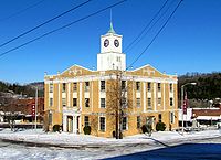 Jackson County Courthouse in Gainesboro
Location in the state of Tennessee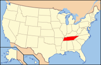
Tennessee's location in the U.S.Founded 1801 Seat Gainesboro Largest city Gainesboro Area
- Total
- Land
- Water
320 sq mi (828 km²)
309 sq mi (800 km²)
11 sq mi (28 km²), 3.34%Population
- (2000)
- Density
10,984
36/sq mi (14/km²)Time zone Central: UTC-6/-5 Jackson County is a county located in the U.S. state of Tennessee. As of 2000, the population was 10,984. The 2005 Census Estimate placed the population at 11,072.[1] Its county seat is Gainesboro[2].
Jackson is part of the Cookeville, Tennessee, Micropolitan Statistical Area.
Contents
Geography
According to the U.S. Census Bureau, the county has a total area of 320 square miles (828.8 km2), of which 309 square miles (800.3 km2) is land and 11 square miles (28.5 km2) (3.34%) is water.
Adjacent counties
- Clay County (north)
- Overton County (east)
- Putnam County (south)
- Smith County (southwest)
- Macon County (northwest)
History
Jackson County was created by an act of the Tennessee General Assembly on November 6, 1801. It was the eighteenth county established in the state. It was formed from part of Smith County plus Indian lands. The county name honors Andrew Jackson (1767–1845), U.S. congressman and senator, Tennessee Supreme Court judge, troop commander at the Battle of New Orleans, and the seventh President of the United States.
In the 1790s, a federal outpost known as Fort Blount was built about 10 miles (16 km) west of Gainesboro along the Cumberland River, in what is now the western part of the county. The fort served as an important stopover for travellers along Avery's Trace. Between 1807 and 1819, Williamsburg, a community that developed on the site of the fort, served as the seat of Jackson County.[3]
Early historical records of the county were destroyed by a courthouse fire on August 14, 1872.[4]
Demographics
 Age pyramid for Jackson County[5]
As of the census[6] of 2000, there were 10,984 people, 4,466 households, and 3,139 families residing in the county. The population density was 36 people per square mile (14/km²). There were 5,163 housing units at an average density of 17 per square mile (6/km²). The racial makeup of the county was 98.63% White, 0.15% Black or African American, 0.34% Native American, 0.06% Asian, 0.03% Pacific Islander, 0.12% from other races, and 0.67% from two or more races. 0.81% of the population were Hispanic or Latino of any race.
There were 4,466 households out of which 28.80% had children under the age of 18 living with them, 55.30% were married couples living together, 10.30% had a female householder with no husband present, and 29.70% were non-families. 25.50% of all households were made up of individuals and 10.20% had someone living alone who was 65 years of age or older. The average household size was 2.43 and the average family size was 2.89.
In the county, the population was spread out with 22.30% under the age of 18, 7.80% from 18 to 24, 28.20% from 25 to 44, 26.80% from 45 to 64, and 15.00% who were 65 years of age or older. The median age was 40 years. For every 100 females there were 97.80 males. For every 100 females age 18 and over, there were 94.90 males.
The median income for a household in the county was $26,502, and the median income for a family was $32,088. Males had a median income of $24,759 versus $19,511 for females. The per capita income for the county was $15,020. About 15.10% of families and 18.10% of the population were below the poverty line, including 15.10% of those under age 18 and 22.50% of those age 65 or over.
Cities and towns
- Gainesboro
- Granville (unincorporated)
- Nameless (unincorporated)
- North Springs (unincorporated)
- Whitleyville (unincorporated)
See also
References
- ^ U.S. Census Bureau county estimates for Tennessee
- ^ "Find a County". National Association of Counties. http://www.naco.org/Counties/Pages/FindACounty.aspx. Retrieved 2011-06-07.
- ^ Benjamin Nance, Fort Blount. Tennessee Encyclopedia of History and Culture, 2002. Retrieved: 5 February 2010.
- ^ http://ajlambert.com/history/hst_jct.pdf
- ^ Based on 2000 census data
- ^ "American FactFinder". United States Census Bureau. http://factfinder.census.gov. Retrieved 2008-01-31.
External links

Macon County Clay County 
Overton County  Jackson County, Tennessee

Smith County Putnam County Categories:- Tennessee counties
- Jackson County, Tennessee
- 1801 establishments in the United States
- Cookeville micropolitan area
- Populated places established in 1801


Wikimedia Foundation. 2010.