- Mount Seymour Provincial Park
-
Mount Seymour Provincial Park 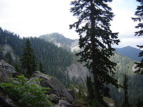
Mount Seymour Provincial Park. September, 2005
East slopes, looking north toward Mt. ElsayLocation of Mount Seymour Provincial Park in British Columbia
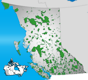
Location British Columbia, Canada Nearest city North Vancouver Coordinates 49°23′6″N 122°56′7″W / 49.385°N 122.93528°WCoordinates: 49°23′6″N 122°56′7″W / 49.385°N 122.93528°W Area 35 km² Established 1936 Governing body BC Parks Mount Seymour Provincial Park is a 35 km² park in Vancouver, British Columbia's North Shore Mountains. It is located approximately 15 km from Downtown Vancouver.
Contents
History and Geography
Established in 1936,[1] the park is in a mountain wilderness setting and several mountain peaks lie within its boundaries, including Mount Bishop, Mount Elsay, Runner Peak, and Mount Seymour. The highest elevation in the park is the summit of Mount Bishop at 1509 metres followed by Mount Seymour, for which the park is named, at 1449 metres.
The park contains several lakes, including Elsay Lake (the largest), De Pencier Lake, Gopher Lake, and Goldie Lake. These lakes drain eastward into Indian Arm. Other smaller lakes and ponds drain westward into the Seymour River.Recreation
There is an extensive network of mountain biking, hiking, and equestrian trails on the lower mountain, while the upper mountain also serves hikers, mountaineers, picknicking, skiing, snowboarding, snowshoeing, snowtubing, tobogganing, and backcountry camping. The ski slopes on the mountain are managed by a private operator, Mount Seymour Resorts Ltd.
Accidents and rescues
Due to its proximity to a large metropolitan area, Mount Seymour Provincial Park attracts larger numbers of visitors and recreational users than many other rugged, mountainous areas. This in part, has led to hundreds of lost, stranded or injured hikers, skiers and snowshoers requiring rescue, some of whom have died.[2]
Access
Access to the park is by way of the all-weather Mount Seymour Road in North Vancouver.
References
- ^ Ministry of Environment- Mount Seymour Provincial Park History
- ^ "The Blazer". Western Living Magazine, Oct. 2001. by Charles Montgomery.
External links
- Mount Seymour Provincial Park official site
- BC Parks - Mt. Seymour Map and Upper Mountain Trails
- Incident summaries (Search and Rescue), Provincial Emergency Program
- MountSeymour.com (Seymour Resorts Ltd.)
Categories:- North Vancouver (district municipality), British Columbia
- Provincial Parks of British Columbia
- Tourism in British Columbia
- Geography of British Columbia


Wikimedia Foundation. 2010.