- Collie, Western Australia
-
Collie
Western Australia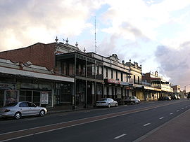
Main street of Collie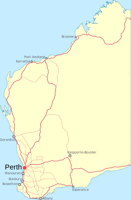
 Collie
Population: 7,084(2006)[1] Established: 1897 Postcode: 6225 Elevation: 204 m (669 ft) [2] Location: LGA: Shire of Collie State District: Collie-Preston Federal Division: Forrest Mean max temp Mean min temp Annual rainfall 22.5 °C
73 °F8.4 °C
47 °F940.2 mm
37 inCoordinates: 33°21′47″S 116°09′22″E / 33.363°S 116.156°E
Collie is a town in the South West region of Western Australia, 213 kilometres (132 mi) south of the state capital, Perth, and 59 kilometres (37 mi) inland from the regional city and port of Bunbury. It is near the junction of the Collie and Harris Rivers, in the middle of dense jarrah forest and the only coalfields in Western Australia. At the 2006 census, Collie had a population of 7,084.[1]
Collie is mainly known as a coal-producing centre, but also offers industrial, agricultural and aquaculture tourism industries. Muja Power station is located east of the town, and to its west is the Wellington Dam, a popular location for fishing, swimming and boating.
The town is named after the river on which it is situated. James Stirling named the Collie River, which in turn is named after Dr Alexander Collie. He and William Preston were the first Europeans to explore the area in 1829.[3]
Coal was discovered in the area by a shepherd named George Marsh in the early 1880s. The coal fields were developed in the late 1890s and the townsite surveyed and gazetted in 1897.[4]
Collie was once referred to as a "dirty mining town",[5] but on 8 April 2006 it won the Australian Tidy Towns Competition from finalists from six States and the Northern Territory.[6] Collie was named the top Tidy Town because of the commitment of the community to recycling, waste management, beautification and community projects.
Contents
Industry and economy
Collie has a significant role in the provision of electricity for Western Australia. There are two coal mines in the town and three power stations. The government of Western Australia will soon commission a new base load power station, for which a number of Collie base proposals have been made.
Initially Western Collieries, the Wesfarmers Premier Coal mine continues to produce 3-4 million tonnes of coal per year.[7] It contains enough reserves for another 100 years of mining at the present rate.[7] The Griffin Coal mine is owned by Ric Stowe.[8]
Education
Collie has five primary schools, Allanson Primary School, Fairview Primary School, Amaroo Primary School, Saint Brigid's Catholic College and Wilson Park Primary School and one high school, Collie Senior High School.
Tourism and facilities
Tourist attractions at Collie include the Steam Locomotive Museum, Collie Museum and Wellington Dam. Parks include Soldier's Memorial Park and natural features include Stockton Lake and Collie River.
Collie also hosts the Kostecki Motorplex, one of Western Australia's only permanent motorsport venues outside the Perth metropolitan area.
Geography
Climate
Collie experiences a Mediterranean climate with hot, dry summers and cool, wet winters (Köppen climate classification Csb).
Climate data for Collie Month Jan Feb Mar Apr May Jun Jul Aug Sep Oct Nov Dec Year Average high °C (°F) 30.5
(86.9)30.1
(86.2)27.3
(81.1)23.1
(73.6)18.9
(66.0)16.3
(61.3)15.1
(59.2)16.3
(61.3)18.1
(64.6)20.7
(69.3)24.8
(76.6)28.3
(82.9)22.5 Average low °C (°F) 13.2
(55.8)13.1
(55.6)11.5
(52.7)8.7
(47.7)6.3
(43.3)5.0
(41.0)4.2
(39.6)4.5
(40.1)5.8
(42.4)7.4
(45.3)9.7
(49.5)11.7
(53.1)8.4 Precipitation mm (inches) 14.8
(0.583)14.2
(0.559)23.6
(0.929)48.2
(1.898)125.9
(4.957)180.3
(7.098)179.4
(7.063)140.6
(5.535)99.9
(3.933)64.5
(2.539)32.1
(1.264)16.0
(0.63)939.5
(36.988)Avg. rainy days 1.7 1.9 2.8 5.5 10.2 13.4 14.5 13.2 11.0 8.3 4.9 2.7 90.1 Source: [9] Gallery
-
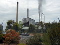
Muja Power Station
-

Collie Railway Station
-
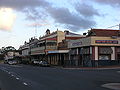
Main Street, Collie
References
- ^ a b Australian Bureau of Statistics (25 October 2007). "Collie (Urban Centre/Locality)". 2006 Census QuickStats. http://www.censusdata.abs.gov.au/ABSNavigation/prenav/LocationSearch?collection=Census&period=2006&areacode=UCL504600&producttype=QuickStats&breadcrumb=PL&action=401. Retrieved 15 October 2007.
- ^ "Climate statistics for Australian locations - Collie". Bureau of Meteorology (Australia). http://www.bom.gov.au/climate/averages/tables/cw_009628.shtml. Retrieved 15 October 2007.
- ^ Western Australian Land Information Authority. "History of country town names". http://www.landgate.wa.gov.au/corporate.nsf/web/History+of+country+town+names. Retrieved 2011-05-30.
- ^ Western Australian Land Information Authority. "History of country town names". http://www.landgate.wa.gov.au/corporate.nsf/web/History+of+country+town+names. Retrieved 2010-09-26.
- ^ Sustainability DoE Issue 9. Retrieved 2 November 2006.[dead link]
- ^ 2006 Tidy Town Media Release www.collie.wa.gov.au. Retrieved 13 August 2006.
- ^ a b Premier Coal. Retrieved 12 August 2007.
- ^ Magnate digs in against $100m tax claim Vanda Carson, The Australian, 27 September 2006. Retrieved 6 August 2007.
- ^ "Climate statistics for Collie". Australian Bureau of Meteorology. August 2011. http://www.bom.gov.au/climate/averages/tables/cw_009628.shtml.
External links
Towns in the South West region of Western Australia Major centres Bunbury · Busselton · Collie · Dunsborough · Harvey · Manjimup · Margaret River
Towns Acton Park · Alexandra Bridge · Allanson · Augusta · Balingup · Benger · Binningup · Boyanup · Boyup Brook · Bramley · Bridgetown · Brookhampton · Brunswick Jn. · Burekup · Capel · Carbunup River · Chowerup · Cookernup · Cowaramup · Cundinup · Dardanup · Deanmill · Dingup · Dinninup · Donnelly River · Donnybrook · Elgin · Ferguson · Forest Grove · Forrest Beach · Gnarabup · Gracetown · Greenbushes · Hester · Jardee · Jarrahwood · Karridale · Kirup · Kudardup · Kulikup · Ludlow · Mayanup · Metricup · Mullalyup · Myalup · Nannup · Nornalup · Northcliffe · Nyamup · Pemberton · Peppermint Grove Beach · Prevelly · Quindalup · Quinninup · Roelands · Rosa Brook · Shotts · Stratham · Uduc · Vasse · Walpole · Waterloo · Wilga · Windy Harbour · Witchcliffe · Wokalup · Wonnerup · Worsley · Yallingup · Yarloop · Yornup
Categories:- Towns in Western Australia
- South West (Western Australia)
- Mining towns in Western Australia
-


Wikimedia Foundation. 2010.