- Clerques
-
Clerques
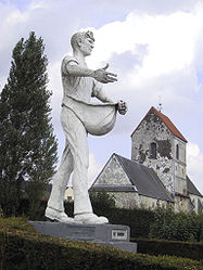
The Sower and Saint-Barthélémy’s church 

 ClerquesLocation within Nord-Pas-de-Calais region
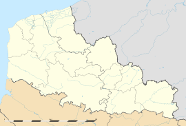 Clerques
Administration Country France Region Nord-Pas-de-Calais Department Pas-de-Calais Arrondissement Saint-Omer Canton Ardres Intercommunality Région d'Ardres et de la Vallée de la Hem Mayor Marc Garenaux Statistics Elevation 37–173 m (121–568 ft)
(avg. 47 m/154 ft)Land area1 6.39 km2 (2.47 sq mi) Population2 213 (1999) - Density 33 /km2 (85 /sq mi) INSEE/Postal code 62228/ 62890 1 French Land Register data, which excludes lakes, ponds, glaciers > 1 km² (0.386 sq mi or 247 acres) and river estuaries. 2 Population without double counting: residents of multiple communes (e.g., students and military personnel) only counted once. Coordinates: 50°47′37″N 1°59′43″E / 50.7936111111°N 1.99527777778°E
Clerques is a commune in the Pas-de-Calais department in the Nord-Pas-de-Calais region of France.
Contents
Geography
A small farming village situated 10 miles (16 km) northwest of Saint-Omer, on the D217 road, nestled in the valley of the river Hem at the foot of the Boulonnais, which is a wooded ridge at this point. Two hamlets, Audenfort to the west and Le Hamel to the East, make up the remainder of the commune.
Population
Historical population of Clerques 1962 1968 1975 1982 1990 1999 184 186 180 209 215 213 From the year 1962 on: population without double counting—residents of multiple communes (e.g. students and military personnel) are counted only once. History
The recent history of the village was marked by the flooding of the river, on August 13, 2006. The stone bridge in the village centre, built in 1862, was destroyed after exceptional rainfall upstream at Licques. The river, usually quiet, had accumulated such a speed it turned into an uncontrollable torrent.[1].
Places of interest
- The church of St.Barthélemy, dating from the thirteenth century.
- The chapel of St.Théresa
- Audenfort mill, which ceased to operate in the 1970s, and is now converted into a hotel-restaurant
- The former flour mill at Hamel, now a hydro-electric generator.
- The new symbol of the village: The statue of the Sower, which symbolizes the friendship between the town of Clerques and the Belgian village of Klerken.
See also
References
External links
- Clerques on the Insee website (French)
- Clerques on the Quid website (French)
Categories:- Communes of Pas-de-Calais
- Pas-de-Calais geography stubs


Wikimedia Foundation. 2010.