- Orchid Island, Florida
-
For other use see Orchid Island.
 Indian River shoreline of Sebastian Inlet State Park
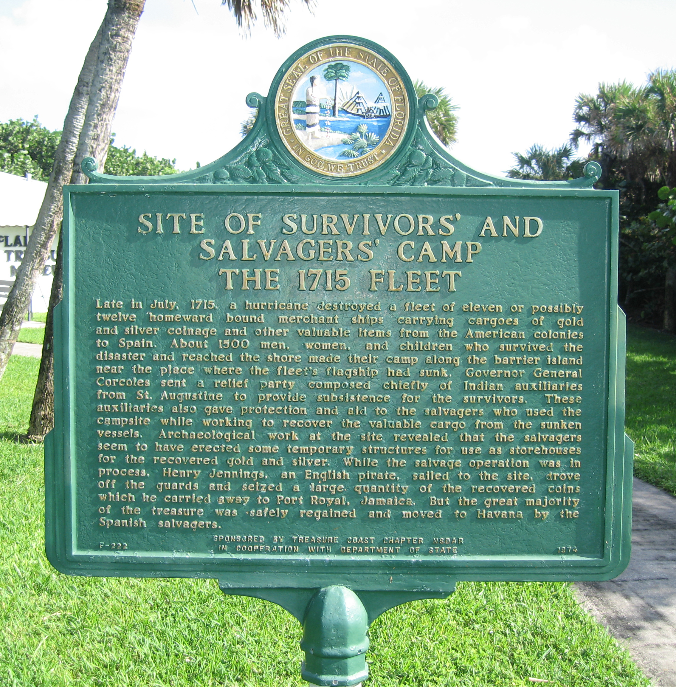
 Survivors' and Salvagers' Camp - 1715 Fleet historic marker near 13180 North A1A, Orchid Island, Florida
Orchid Island, Florida, an Atlantic coastal barrier island located in Indian River County, Florida, is actually the Indian River County part of North Hutchinson Island, although that term in not used in Indian River County.[1] Orchid Island is separated from the mainland on the west by the Indian River Lagoon. Its southern boundary is the county line between Indian River and St. Lucie counties, while its northern boundary is the Sebastian Inlet, which is the county line between Indian River and Brevard counties. The entire island constitutes the Vero Beach, Florida 32963 Zip Code. The island is home to many wealthy residents and luxurious homes.
Contents
Main Roads
The principal north-south road on the island is State Road A1A which runs the entire length of the island. It is called South A-1-A from Beachland Boulevard south and North A-1-A north of Beachland Boulevard, Signs at each county line and at the foot of each bridge from the mainland welcome the visitor to Orchid Island.
South Beach CDP
The area from the southern county line to the Vero Beach city limits is in the South Beach CDP or census designated place.
Sites of Interest
County-maintained Round Island Park abuts the county line on the south and runs from the ocean to the river.[2]
Vero Beach portion
The City of Vero Beach lies on both sides of the Indian River, with its main business and residential areas on the mainland. Two of the island's three bridges from the mainland lie within the city limits. The island part of Vero Beach is primarily residential but has a business area located along Beachland Boulevard which runs from the New Merrill Barber Bridge east to Sexton Plaza on the Ocean front, The Riomar Country Club built in the 1920s set the tone for residential development on the island, but two 13-story condominium apartment buildings built in the 1980s threatened to change that. The city, though, adopted stringent planning and zoning regulation to prevent further highrise development.[3]
Sites of interest
- Riverside Park at the foot of the New Merrill Barber Bridge is the location of the Vero Beach Art Museum,[4] the Riverside Theatre and the Riverside Children's Theatre.[5]
- Driftwood Inn and Restaurant, listed on the National Register of Historic Places is at Sexton Park on the ocean.
Town of Indian River Shores
The upscale town of Indian River Shores borders the City of Vero Beach on the south and the Wabasso Beach CDP on the north.[6]
John's Island
John's Island is an upscale gated country club community on 1,650 acres (6.7 km2) within the Town of Indian River Shores.[7]
Wabasso Beach CDP
Wabasso Beach is a CDP or census designated place lying north of the Town of Indian River Shores and south of the Town of Orchid and is centered around the intersection of North A-1-A and Wabasso Road, which comes across the Wabasso Bridge from the mainland. County-maintained Wabasso Beach Park is located just east of this intersection.[2]
Sites of interest
- Disney's Vero Beach Resort is located in Wabasso Beach..[8]
Town of Orchid
The Town of Orchid lies north of the Wabasso Beach CDP and is mainly to the north of Wabasso Road (SR 510) and now consists primarily of the Orchid Island Golf and Beach Club, although it was originally incorporated by the grove owners located in the area and covered somewhat different lands. The town does have some territory on the Atlantic.[9]
North Beach CDP
The unincorporated area north of the Town or Orchid to the Sebastian Inlet is in the North Beach CDP, or census designated place.
Sites of interest
- McLarty Treasure Museum at Sebastian Inlet State Park[10]
- Pelican Island National Wildlife Refuge is located in the Indian River Lagoon west of North Beach CDP.[11]
- Sebastian Inlet State Park is located on the north end and extends across the Sebastian Inlet into Brevard County.[12]
Archie Carr National Wildlife Refuge
The Archie Carr National Wildlife Refuge established for the protection of sea turtles extends from Wabasso Beach on Orchid Island north along the coast to Melbourne Beach
Income on the island
- Florida locations by per capita income ranks island places as follows:
- 006. Orchid;
- 009. Indian River Shores;
- 010. South Beach CDP;
- 015. North Beach CDP;
- 041. Wabasso Beach; and
- 133. Vero Beach (but this includes the mainland)
- According to the IRS,[13] Zip Code Vero Beach, FL 32963, which is exclusive to Orchid Island is the:
- 57th wealthiest in the United States; and
- 3rd wealthiest in Florida after Palm Beach and Longboat Key.
References
- ^ http://www.florida-living.us/articles/orchid_island.php
- ^ a b WWW.IRCGOV.COM - Indian River County Board of County Commissioners - Public Works - Parks Maintenance Division - All Parks
- ^ Vero Beach History, Summary
- ^ The Vero Beach Museum of Art
- ^ Riverside Theatre - Home
- ^ http://www.indianrivershores-fl.gov/
- ^ John's Island Real Estate Company: Community
- ^ http://www.luxuryhomesofvero.com/Orchid-Island.php
- ^ Town of Orchid: About Our Town
- ^ Treasure coin McLarty Treasure Museum Located On A National Historical Landmark Site Of The 1715 Spanish Plate Fleet McLarty Treasure Museum
- ^ Pelican Island National Wildlife Refuge
- ^ Main Page - Sebastian Inlet State Park » Florida State Parks
- ^ 100 wealthiest zip codes in the United States
External links
- Official Town of Indian River Shores Website
- Town of Orchid website
- Pelican Island National Wildlife Refuge
- Sebastian Inlet State Park
- City Of Vero Beach website
- Barrier Islands of the Treasure Coast
Municipalities and communities of Indian River County, Florida County seat: Vero Beach Cities 
Towns CDPs Unincorporated
communitiesCoordinates: 27°51′31″N 80°26′59″W / 27.85861°N 80.44972°W
Categories:- Barrier islands of Florida
- Beaches of Florida
- Geography of Indian River County, Florida


Wikimedia Foundation. 2010.