- Dover Beaches South, New Jersey
-
Dover Beaches South, New Jersey — CDP — Map of Toms River Beaches South CDP in Ocean County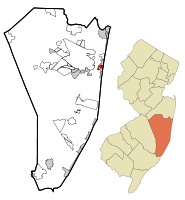
Coordinates: 39°57′16″N 74°4′32″W / 39.95444°N 74.07556°WCoordinates: 39°57′16″N 74°4′32″W / 39.95444°N 74.07556°W Country United States State New Jersey County Ocean Area – Total 1.1 sq mi (2.8 km2) – Land 0.6 sq mi (1.6 km2) – Water 0.4 sq mi (1.2 km2) Elevation 7 ft (2 m) Population (2000) – Total 1,594 – Density 2,568.6/sq mi (991.7/km2) Time zone Eastern (EST) (UTC-5) – Summer (DST) EDT (UTC-4) FIPS code 34-18151[1] GNIS feature ID 1852608[2] Dover Beaches South more commonly known as Ortley Beach is a census-designated place and unincorporated area located within Toms River Township, in Ocean County, New Jersey. As of the 2000 United States Census, the CDP population was 1,594. It is more commonly called Ortley Beach. Toms River Beaches South is situated on the Barnegat Peninsula, a long, narrow barrier peninsula that separates Barnegat Bay from the Atlantic Ocean.
Toms River Township is split by the United States Census Bureau into three CDPs; Toms River CDP on the mainland comprising over 95% of the Township's population, along with Dover Beaches North and Dover Beaches South.
Contents
Geography
Dover Beaches South is located at 39°57′16″N 74°4′32″W / 39.95444°N 74.07556°W (39.954568, -74.075679)[3]and is bordered by the municipalities of Lavallette and Seaside Heights.
According to the United States Census Bureau, the CDP has a total area of 2.8 km² (1.1 mi²). 1.6 km² (0.6 mi²) of it is land and 1.2 km² (0.4 mi²) of it (42.06%) is water.
Demographics
As of the census[1] of 2000, there were 1,594 people, 862 households, and 422 families residing in the CDP. The population density was 992.7/km² (2,568.6/mi²). There were 2,622 housing units at an average density of 1,632.8/km² (4,225.1/mi²). The racial makeup of the CDP was 92.93% White, 0.46% African American, 0.31% Native American, 0.25% Asian, 0.06% from other races, and 1.38% from two or more races. Hispanic or Latino of any race were 4.13% of the population. Most of the population is made up of people of Italian descent of the Roman Catholic faith
There were 862 households out of which 13.2% had children under the age of 18 living with them, 38.2% were married couples living together, 8.7% had a female householder with no husband present, and 51.0% were non-families. 46.4% of all households were made up of individuals and 18.6% had someone living alone who was 65 years of age or older. The average household size was 1.85 and the average family size was 2.59.
In the CDP the population was spread out with 12.6% under the age of 18, 4.2% from 18 to 24, 26.2% from 25 to 44, 31.2% from 45 to 64, and 25.7% who were 65 years of age or older. The median age was 49 years. For every 100 females there were 94.6 males. For every 100 females age 18 and over, there were 91.6 males.
The median income for a household in the CDP was $38,407, and the median income for a family was $53,811. Males had a median income of $38,984 versus $35,735 for females. The per capita income for the CDP was $26,702. About 5.5% of families and 10.0% of the population were below the poverty line, including 25.9% of those under age 18 and 6.0% of those age 65 or over.
References
- ^ a b "American FactFinder". United States Census Bureau. http://factfinder.census.gov. Retrieved 2008-01-31.
- ^ "US Board on Geographic Names". United States Geological Survey. 2007-10-25. http://geonames.usgs.gov. Retrieved 2008-01-31.
- ^ "US Gazetteer files: 2010, 2000, and 1990". United States Census Bureau. 2011-02-12. http://www.census.gov/geo/www/gazetteer/gazette.html. Retrieved 2011-04-23.
External links
Municipalities and communities of Ocean County, New Jersey Boroughs 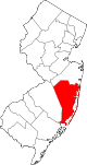
Townships Barnegat | Berkeley | Brick | Eagleswood | Jackson | Lacey | Lakewood | Little Egg Harbor | Long Beach | Manchester | Ocean | Plumsted | Stafford | Toms River
CDPs Barnegat | Beach Haven West | Cassville | Cedar Glen Lakes | Cedar Glen West | Crestwood Village | Dover Beaches North | Dover Beaches South | Forked River | Holiday City-Berkeley | Holiday City South | Holiday Heights | Lakewood | Leisure Knoll | Leisure Village | Leisure Village East | Leisure Village West-Pine Lake Park | Manahawkin | Mystic Island | New Egypt | North Beach Haven | Ocean Acres | Pine Ridge at Crestwood | Silver Ridge | Toms River | Vista Center | Waretown
Communities Bayville | Chadwick Beach Island | Harmony | High Bar Harbor | Jackson Mills | Lanoka Harbor | Loveladies | Parkertown | Silverton | Warren Grove | West Creek | West Tuckerton | Whitesville | Whiting
[[Category:Toms River, New Jersey]
Categories:- Populated places in Ocean County, New Jersey
- Census-designated places in New Jersey


Wikimedia Foundation. 2010.