- Union Township, Union County, New Jersey
-
- Not to be confused with Union Township, Hunterdon County, New Jersey and Union City, New Jersey in Hudson County.
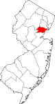
Map of Union Township in Union County. Inset: Location of Union County highlighted in the State of New Jersey. Census Bureau map of Union Township, Union County, New Jersey
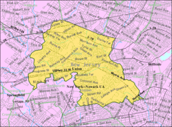
Coordinates: 40°41′49″N 74°16′14″W / 40.69694°N 74.27056°W Country United States State New Jersey County Union Incorporated November 23, 1808 Government[1] – Type Township (New Jersey) – Mayor Joseph Florio – Administrator Frank Bradley[2] Area – Total 9.1 sq mi (23.6 km2) – Land 9.1 sq mi (23.6 km2) – Water 0.0 sq mi (0.0 km2) Elevation[3] 121 ft (37 m) Population (2010 Census)[4] – Total 56,642 – Density 6,224.4/sq mi (2,400.1/km2) Time zone Eastern (EST) (UTC-5) – Summer (DST) EDT (UTC-4) ZIP code 07083 Area code(s) 908 FIPS code 34-74480[5][6] GNIS feature ID 0882212[7] Website http://www.uniontownship.com Union is a Township in Union County, New Jersey, United States. In the 18th century, the area that is now Union was then called Connecticut Farms. As of the 2010 United States Census, the township population increased to a record high of 56,642.
Union Township was incorporated as a township by an Act of the New Jersey Legislature on November 23, 1808, from portions of Elizabeth Township, while the area was still part of Essex County. It became part of the newly formed Union County on March 19, 1857. Portions of the township have been taken to form Linden Township (March 4, 1861), Roselle Park, (March 22, 1901), Kenilworth (May 13, 1907) and Hillside (April 3, 1913).[8]
Contents
Geography
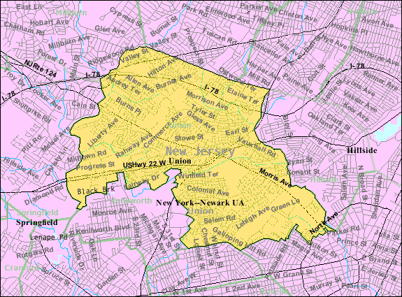
The Township of Union is located on the northern-central edge of Union County and is bordered by eight municipalities: Hillside to the east, Elizabeth to the southeast, Roselle Park and Kenilworth to the south and Springfield Township to the west. Northwest of the township lies Millburn, to the north lies Maplewood and to the northeast lies Irvington, all in Essex County.
According to the United States Census Bureau, the township has a total area of 9.1 square miles (24 km2), all of it land.
Demographics
Historical populations Census Pop. %± 1930 16,472 — 1940 24,730 50.1% 1950 38,004 53.7% 1960 51,499 35.5% 1970 53,077 3.1% 1980 50,184 −5.5% 1990 50,024 −0.3% 2000 54,405 8.8% 2010 56,642 4.1% Population 1930 - 1990.[9] As of the census[5] of 2000, there were 54,405 people, 19,534 households, and 14,162 families residing in the township. The population density was 5,968.1 people per square mile (2,303.3/km²). There were 20,001 housing units at an average density of 2,194.1 per square mile (846.8/km²). An example of a diverse city in the United States, the racial makeup of the township was 67.66% White, 19.76% African American, 0.15% Native American, 7.72% Asian, 0.02% Pacific Islander, 2.44% from other races, and 2.24% from two or more races. Hispanic or Latino of any race were 8.93% of the population.
There were 19,534 households out of which 32.0% had children under the age of 18 living with them, 55.5% were married couples living together, 13.1% had a female householder with no husband present, and 27.5% were non-families. 23.8% of all households were made up of individuals and 13.3% had someone living alone who was 65 years of age or older. The average household size was 2.71 and the average family size was 3.25.
In the township the population was spread out with 22.3% under the age of 18, 8.9% from 18 to 24, 29.3% from 25 to 44, 22.3% from 45 to 64, and 17.3% who were 65 years of age or older. The median age was 39 years. For every 100 females there were 87.9 males. For every 100 females age 18 and over, there were 83.2 males.
The median income for a household in the township was $59,173, and the median income for a family was $68,707 (these figures had risen to $68,979 and $80,260 respectively as of a 2007 estimate[10]). Males had a median income of $45,299 versus $35,604 for females. The per capita income for the township was $24,768. About 3.0% of families and 4.2% of the population were below the poverty line, including 4.6% of those under age 18 and 5.5% of those age 65 or over.
Government
Local government
Union Township is governed under the Township form of government with a five-member Township Committee. The Township Committee is elected directly by the voters in partisan elections to serve three-year terms of office on a staggered basis, with one or two seats coming up for election each year.[1] At an annual reorganization meeting, the Township Committee selects one of its members to serve as Mayor. The Mayor, in addition to voting as a member of the Township Committee, presides over the meetings of the committee and carries out ceremonial duties.
As of 2011[update], members of the Union Township Committee are Mayor, Joseph Florio, Deputy Mayor, Clifton People, Jr., Suzette Cavadas, Manuel Figueiredo and Anthony Terrezza.[11]
Federal, state and county representation
Union Township is split between the 7th and 10th Congressional districts. New Jersey's Seventh Congressional District is represented by Leonard Lance (R, Clinton Township). New Jersey's Tenth Congressional District is represented by Donald M. Payne (D, Newark). New Jersey is represented in the United States Senate by Frank Lautenberg (D, Cliffside Park) and Bob Menendez (D, Hoboken).
Union is in the 20th Legislative District of the New Jersey Legislature, which is represented in the New Jersey Senate by Raymond Lesniak (D, Union) and in the New Jersey General Assembly by Joseph Cryan (D, Union) and Annette Quijano (D, Elizabeth).[12]
Union County is governed by a Board of Chosen Freeholders, whose nine members are elected at-large to three-year terms of office on a staggered basis with three seats coming up for election each year.[13] As of 2011, Union County's Freeholders are Chairman Deborah P. Scanlon (Union, term ends December 31, 2012)[14], Vice Chairman Alexander Mirabella (Fanwood, 2012)[15], Linda Carter (Plainfield, 2013)[16], Angel G. Estrada (Elizabeth, 2011)[17], Christopher Hudak (Linden, 2011)[18], Mohamed S. Jalloh (Roselle, 2012)[19], Bette Jane Kowalski (Cranford, 2013)[20], Daniel P. Sullivan (Elizabeth, 2013)[21] and Nancy Ward (Linden, 2011).[22][23]
Mayors of Union
# Mayor Years in Office Party Terms Notes 1 John Leonard 1879–1883 1-4 First Term 2 James A. Burnett 1884–1885 5 & 6 3 John Leonard 1886 7 Second Term 4 James B. Woodruff 1887–1891 8-12 Five Consecutive Terms 5 John Tunison 1892–1893 13 & 14 Two Consecutive Terms 6 Daniel H. Beach 1894–1895 15 & 16 Two Consecutive Terms 7 William P. Bonnell 1896 17 8 John H. Doremus 1897 18 First Term 9 Daniel H. Beach 1898 19 Third Term 10 William A. Bainbridge 1899 20 11 John H. Doremus 1900 21 Second Term 12 Daniel H. Beach 1901 22 Fourth Term 13 John H. Doremus 1902–1903 23 & 24 Third & Fourth Terms 14 Walter A. Miller 1904–1905 25 & 26 Two Consecutive Terms 15 Daniel B. Wade 1906 25 First Term 16 John H. Doremus 1907 26 Fourth Term 17 Daniel H. Beach 1908 27 18 Daniel B. Wade 1909 28 19 Gottlieb Schnabel 1910 29 20 Daniel H. Beach 1911 30 21 Howard B. Kline 1912 31 22 Gottlieb Schnabel 1913 32 22 Daniel H. Beach 1914 33 23 Cornelius E. Blanchard 1915 34 24 George A. Bashford 1916 35 25 Daniel H. Beach 1917 36 26 Harry Schmitt 1918 37 27 George A. Bashford 1919 38 28 Daniel H. Beach 1920–1921 39 & 40 29 George A. Bashford 1922 41 30 Ambrose B. Kline 1923 42 31 Charles W. Wink 1924–1926 43-45 32 Ambrose B. Kline 1927–1928 46 & 47 33 Gustav Hummel, Jr. 1929–1931 48-50 34 Max A. Schoenwalder 1932–1933 51 & 52 35 Charles Schramm 1934–1939 53-58 Resigned in 1939. 36 Fred Edward Biertuempfel 1939–1973 Republican 59-93 37 Samuel Rabkin 1973 Republican 93 Finished Biertuempfel's term. Rabkin field named after him. 38 Anthony E. Russo 1974 Democrat 94 39 James C. Conlon 1975 Republican 95 40 John S. Zimmerman 1976 Democrat 96 41 Edward Goodkin 1977 Republican 97 42 James C. Conlon 1978–1980 Democrat 98 & 99 43 Edward Weber 1981 Democrat 100 44 James C. Conlon 1982 Republican 101 45 Anthony E. Russo 1983 Democrat 102 46 1984 103 47 1985 104 48 1986 105 49 Diane Heelan 1987 Republican 106 Union's first female mayor 50 1988 107 51 1989 108 52 1990 109 53 Anthony E. Russo 1991 Democrat 110 54 1992 111 55 1993 112 56 Jerome Petti 1994 Democrat 113 57 Greg Muller 1995 Republican 114 58 Jerome Petti 1996 Democrat 115 59 Greg Muller 1997 Republican 116 60 Anthony L. Terrezza 1998–1999 Democrat 117-118 61 2000 119 62 Peter A. Capodice 2001 Democrat 120 63 Patrick Scanlon 2002 Democrat 121 64 Brenda C. Restivo 2003 Democrat 122 65 Anthony L. Terrezza 2004 Democrat 123 66 Joseph Florio 2005 Democrat 124 67 Peter A. Capodice 2006 Democrat 125 68 Brenda C. Restivo 2007 Democrat 126 Second Term 69 Clifton Peoples Jr. 2008 Democrat 127 Union's first African-American Mayor 70 Anthony L. Terrezza 2009–2010 Democrat 128-129 71 Joseph Florio 2011 (Currently mayor) Democrat 130 Second term as mayor. Education
Main article: Union Public School DistrictThe Union Public School District serves students in preschool through grade twelve. The ten schools currently in operation (with 2008-09 enrollment data from the National Center for Education Statistics[24] are six K-4 elementary schools — Battle Hill School (441 students), Hannah Caldwell School (550), Connecticut Farms Elementary School (458), Franklin School (496), Livingston School (427) and Washington School (581) — Central Five-Jefferson School for grade 5 (567), both Burnet Middle School (1,020) and Kawameeh Middle School for grades 6 though 8 (713) and Union High School for grades nine through twelve (2,449).
The annual operating budget for the district is approximately 91 million dollars. The district employs 635 professional staff and 380 support personnel. The enrollment of students in the district was 7,776 as of the 2008-09 school year.[25]
Union was threatened with being the first town north of the Mason-Dixon Line to suffer from penalties as a result of school segregation. The area of Vauxhall was primarily black and Jefferson Elementary School was disproportionately black compared to the rest of the town. Union avoided problems by converting Jefferson Elementary into a sixth-grade only school called Central 6 and bused the Jefferson students to all the other elementary schools. It was later renamed Central 5 and is now used as a one-year school for fifth-grade students.
Union is also home to Kean University, several private nursery schools, two Roman Catholic elementary schools: St. Michael's and Holy Spirit, and the Deron School, a private school for learning disabled students ages 5–13.[26]
History
Union Township was the site of the Battle of Connecticut Farms, one of the last battles between British and American forces during the American Revolutionary War. On June 6, 1780, British troops, led by Hessian General Wilhelm von Knyphausen, boarded boats on Staten Island bound for Elizabeth, New Jersey. At midnight, 5,000 troops started to land. They expected the Continental Army to give little resistance, believing that they were tired of the war and were poorly fed and paid. They also expected the citizens of New Jersey to welcome them. They were wrong on both counts and were unable to make their way to and through the Hobart Gap.
Transportation
Union is traversed by a network of local and regional roadways including the Garden State Parkway, Interstate 78, U.S. Route 22, and Route 82 (Morris Avenue).
Union has an NJ Transit rail station on the Raritan Valley Line, (formerly the mainline of the Lehigh Valley Railroad) which opened in 2003. NJ Transit also provides bus service to New York City and New Jersey points.
Former Rahway Valley Railroad freight line, now abandoned, crosses through Union. This line, presently licensed to Morristown & Erie Railroad, is in the process of revitalization after which it will link NJ Transit's Morris & Essex lines at Summit to Staten Island.
Newark Liberty International Airport is approximately six miles east of Union.
Parts and sections of Union
- Five Points, Area around the junction of Galloping Hill Rd, Chestnut St, Salem Rd, Delaware Ave, Walton Ave, and Tucker Ave.
- Brookside Heights (Curreyville), Area west of Vauxhall Road, past Tiffany's Bar & Restaurant
- Vauxhall, Area of Union north of I-78 and west of Stuyvesant Avenue. Aspirant to become own town, only getting as far as getting its own zip code 07088.
- Union Center, Area around the intersection of Morris and Stuyvesant Avenues.
- Putnam Ridge, a section between Suburban Road, Morris Avenue, Twin Oaks Road, and Colonial Avenue.
- Putnam Manor, a wealthy section between Colonial Ave and Salem Road.
- Orchard Park
- Parkside Manor, a three road section off of Union Terrace, feature in the movie She Devil with Roseanne Barr.
- Larchmont Estates, area bordered by Larchmont Reservation (NW and NE edges), Morris Avenue (SW), Liberty Ave (SE), and Joe Collins Park/Larchmont Reservation (NE edge).
- Green Lane, new community between Kean University and Union Station. Suspenders Restaurant & Pub is located here.
- Fairway Drive, community bordering the Galloping Hill Golf Course.
Notable residents
Notable current and former residents of Union Township include:
- Aminat Ayinde, the second runner-up from Cycle 12 of America's Next Top Model.
- C. Louis Bassano (born 1942) politician who served in both the New Jersey General Assembly and the New Jersey Senate.[27]
- David G. Burnet (1788–1870), president of the interim government of the Republic of Texas during 1836.[citation needed]
- Freddie 'Red' Cochrane (1915–93), professional boxer in the welterweight (147lb) division who became World Champion in 1941 in that class.[28]
- Joe Collins (1922–1989), first baseman for the New York Yankees from 1948 to 1957.[29] A park on Liberty Avenue is named after him.
- Steve Covino (born 1976), radio host currently on Sirius XM Radio -Octane & Maxim Radio's Covino & Rich Show.[citation needed]
- Joseph Cryan (born 1961) represents the 20th legislative district in the New Jersey General Assembly.[30]
- Jamie Fox (born 1954), political strategist.[31]
- Mildred Barry Hughes (1902–95), the first woman elected to the New Jersey Senate, in 1965.[32]
- Ron Karkovice [born 1963] Major League baseball Cather from 1986 to 1997
- Amalya Lyle Kearse (born 1937), a judge of the United States Court of Appeals for the Second Circuit.[33]
- John Daniel King (1904–82), architect who worked on projects such as the Supreme Court Building in New York City.[citation needed]
- Larry Kubin (born 1959), linebacker who played with the Washington Redskins from 1981 to 1984.[34]
- Kelly Kulick (born 1977), professional bowler who became the first woman ever to win a regular Professional Bowlers Association tour title.[35]
- Artie Lange (born 1967), comedian, actor, and Howard Stern Show sidekick since 2001.[36]
- Ray Liotta (born 1954), actor.[37]
- Elliott Maddox (born 1947), professional baseball player with both the New York Yankees 1974-76 and the New York Mets 1978-80.[29]
- Matthew John Rinaldo (born 1931), represented New Jersey in the United States House of Representatives for twenty years, in the 12th congressional district (1973–1983) and in the 7th congressional district (1983–1993).[38]
- Karl Schellscheidt (born 1968), soccer player, educator and entrepreneur.[39]
- Manfred Schellscheidt (born 1941) German-American soccer coach and former player and member of the National Soccer Hall of Fame.[40]
- Darnell Stapleton (born 1985), a former offensive guard for the Pittsburgh Steelers of the National Football League, and an alumnus of Union High School who was a member of the Steelers' Super Bowl XLIII championship team.[41]
- Robert Wuhl (born 1951), actor.[42]
See also
- The Self-Masters Colony
References
- ^ a b 2005 New Jersey Legislative District Data Book, Rutgers University Edward J. Bloustein School of Planning and Public Policy, April 2005, p. 90.
- ^ Township Administrator's Office, Township of Union. Accessed February 13, 2011.
- ^ U.S. Geological Survey Geographic Names Information System: Township of Union, Geographic Names Information System, accessed December 20, 2007.
- ^ 2010 Census: Union County, Asbury Park Press. Accessed June 10, 2011.
- ^ a b "American FactFinder". United States Census Bureau. http://factfinder.census.gov. Retrieved 2008-01-31.
- ^ A Cure for the Common Codes: New Jersey, Missouri Census Data Center. Accessed July 14, 2008.
- ^ "US Board on Geographic Names". United States Geological Survey. 2007-10-25. http://geonames.usgs.gov. Retrieved 2008-01-31.
- ^ "The Story of New Jersey's Civil Boundaries: 1606-1968", John P. Snyder, Bureau of Geology and Topography; Trenton, New Jersey; 1969. p. 241.
- ^ New Jersey Resident Population by Municipality: 1930 - 1990, Workforce New Jersey Public Information Network. Accessed March 1, 2007.
- ^ http://factfinder.census.gov/servlet/ACSSAFFFacts?_event=ChangeGeoContext&geo_id=06000US3403974480&_geoContext=01000US%7C04000US34%7C05000US34021%7C06000US3402122185&_street=&_county=union&_cityTown=union&_state=04000US34&_zip=&_lang=en&_sse=on&ActiveGeoDiv=geoSelect&_useEV=&pctxt=fph&pgsl=010&_submenuId=factsheet_1&ds_name=ACS_2007_3YR_SAFF&_ci_nbr=null&qr_name=null®=null%3Anull&_keyword=&_industry=
- ^ Directory, Union Township. Accessed February 13, 2011.
- ^ "Legislative Roster: 2010-2011 Session". New Jersey Legislature. http://www.njleg.state.nj.us/members/roster.asp. Retrieved 2010-07-12.
- ^ County Government, Union County, New Jersey. Accessed January 6, 2011.
- ^ Vice Chairman Deborah P. Scanlon, Union County, New Jersey. Accessed January 9, 2011.
- ^ Freeholder Alexander Mirabella, Union County, New Jersey. Accessed January 9, 2011.
- ^ Freeholder Linda Carter, Union County, New Jersey. Accessed January 9, 2011.
- ^ Freeholder Angel G. Estrada, Union County, New Jersey. Accessed January 9, 2011.
- ^ Freeholder Christopher Hudak, Union County, New Jersey. Accessed January 9, 2011.
- ^ Freeholder Mohamed S. Jalloh, Union County, New Jersey. Accessed January 9, 2011.
- ^ Freeholder Bette Jane Kowalski, Union County, New Jersey. Accessed January 9, 2011.
- ^ Chairman, Daniel P. Sullivan, Union County, New Jersey. Accessed January 9, 2011.
- ^ Freeholder Nancy Ward, Union County, New Jersey. Accessed January 9, 2011.
- ^ Board of Chosen Freeholders, Union County, New Jersey. Accessed January 9, 2011.
- ^ Data for the Union Public School District, National Center for Education Statistics. Accessed March 23, 2011.
- ^ Data for the Union Public School District, National Center for Education Statistics. Accessed March 23, 2011.
- ^ Home page, The Deron School of New Jersey. Accessed August 13, 2008.
- ^ C. Louis Bassano, New Jersey Legislature, archived by the Internet Archive on February 25, 1998. Accessed May 25, 2010.
- ^ "Freddie (Red) Cochrane, Boxer, 77", The New York Times, January 19, 1993. Accessed December 5, 2007.
- ^ a b Union County Baseball Hall of Fame Will Induct Three New Members, Feb. 11, Union County, New Jersey press release dated December 27, 2006. Accessed July 3, 2007. "Over the years, the awards dinner has honored many local and national baseball luminaries – including Joe Collins of Union, Phil Rizzuto of Hillside, Don Newcombe of Elizabeth, Jeff Torborg of Mountainside, Willie Wilson of Summit, Jake Wood of Elizabeth, and Elliott Maddox of Union."
- ^ Assembly Member Joseph P. Cryan, Project Vote Smart. Accessed August 12, 2007.
- ^ Sullivan, John. "IN PERSON; McGreevey Goes for Muscle", The New York Times, December 1, 2002. Accessed October 23, 2011.
- ^ "Mildred Hughes, 92, New Jersey Senator". New York Times. "Mildred Barry Hughes, who in 1965 was the first woman elected a state senator in New Jersey, died on Jan. 11 at the Cranford, New Jersey Health and Extended Care Center. She was 92 and had lived for many years in Union, New Jersey"
- ^ Goldstein, Tom. "Amalya Lyle Kearse; Woman in the News", The New York Times, June 25, 1979.
- ^ Larry Kubin profile, database Football. Accessed June 6, 2007.
- ^ Kulick became the first woman to win a PBA Tour title on Sunday, beating Chris Barnes in the final of the 45th Tournament of Champions.
- ^ Staff. "'Lucky' Artie Lange is having the time - and movie - of his life", Philadelphia Daily News, September 15, 2006. Accessed February 13, 2011. "Today, the Union, NJ, native takes it up a notch with Artie Lange's Beer League."
- ^ Biography of Ray Liotta, The New York Times, accessed December 6, 2006.
- ^ Matthew John Rinaldo, Biographical Directory of the United States Congress. Accessed September 5, 2007.
- ^ Roselle Catholic High School Alumni Directory 1993. Bernard C. Harris Publishing Company, Inc. White Plains, NY. 1993. p. 49.
- ^ Jones, Grahame L. "Schellscheidt Hoping to Soccer It to Them: U.S. Olympic Coach Would Like to Put America on World Football Map", Los Angeles Times, June 14, 1983. Accessed June 10, 2011. "This is what we do in Union, New Jersey his home with the rec program."
- ^ Rothman, Darnell. "Pittsburgh Steelers' Darnell Stapleton visits school kids at his Union Township alma mater", The Star-Ledger, March 26, 2009. Accessed February 13, 2011.
- ^ Biography of Robert Wuhl, The New York Times, accessed December 6, 2006.
External links
- Union Township website
- Union Public School District
- Union Public School District's 2009–10 School Report Card from the New Jersey Department of Education
- Data for the Union Public School District, National Center for Education Statistics
- Living in Union, N.J. - slideshow by The New York Times
Municipalities and communities of Union County, New Jersey Cities Elizabeth | Linden | Plainfield | Rahway | Summit
Boroughs Fanwood | Garwood | Kenilworth | Mountainside | New Providence | Roselle | Roselle Park
Town Townships Berkeley Heights | Clark | Cranford | Hillside | Scotch Plains | Springfield | Union | Winfield
Unincorporated
communitiesFree Acres | Murray Hill | Vauxhall
Coordinates: 40°42′36″N 74°16′07″W / 40.710052°N 74.268608°W
Categories:- Populated places established in 1808
- Townships in Union County, New Jersey


Wikimedia Foundation. 2010.