- Othery
-
Coordinates: 51°05′N 2°53′W / 51.08°N 2.88°W
Othery 
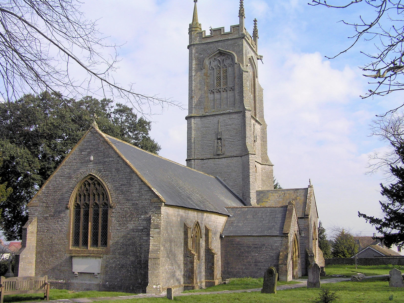
The Church of St Michael
 Othery
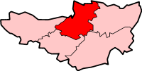
Othery shown within SomersetPopulation 567 [1] OS grid reference ST3823 District Sedgemoor Shire county Somerset Region South West Country England Sovereign state United Kingdom Post town BRIDGWATER Postcode district TA7 Dialling code 01823 Police Avon and Somerset Fire Devon and Somerset Ambulance South Western EU Parliament South West England UK Parliament Bridgwater and West Somerset List of places: UK • England • Somerset The parish and village of Othery, established in 1515, sits on a detached extension of Sowy island on the Somerset Levels. It is 7 miles (11 km) east of Bridgwater and 4 miles (6 km) north-west of Langport. It borders the hamlets and villages of Pathe, Burrowbridge, Middlezoy, Westonzoyland and Aller, which it meets at Beer Wall. The border with Burrowbridge was defined in 1985, reducing Othery to 553 ha (1,366 acres). Many of these borders are defined by rhynes (ditches) and walls (embankments) created and rearranged, from the 13th century onwards, to drain and channel the waters of the River Cary and the River Parrett as they flooded the low-lying levels on their leisurely journey to the Bristol Channel.
Contents
History
The name means "Other-island". The "island" of Othery rising above the Levels is a mixed sedimentary and alluvial deposit: marl, Mercia mudstone, sand and gravel ("Burtle Beds"), peat, and deposits from the basin of the River Parrett. The moors on the shallowest deposits are just 13 feet (4 m) above sea level, with the highest hill, on the southwest side of Othery, standing 82 feet (25 m) above sea level.
The parish of Othery was part of the Whitley Hundred.[2]
Othery once had three pubs, but currently has just one, The London Inn. It has a village shop, a post office, a bakery (Maisey's) and a primary school. There is also a very active village hall . Othery borders two Sites of Special Scientific Interest, both designated in 1985: Southlake Moor and Sedgemoor, to the north of Beer Wall.[3]
Governance
The parish council has responsibility for local issues, including setting an annual precept (local rate) to cover the council’s operating costs and producing annual accounts for public scrutiny. The parish council evaluates local planning applications and works with the local police, district council officers, and neighbourhood watch groups on matters of crime, security, and traffic. The parish council's role also includes initiating projects for the maintenance and repair of parish facilities, as well as consulting with the district council on the maintenance, repair, and improvement of highways, drainage, footpaths, public transport, and street cleaning. Conservation matters (including trees and listed buildings) and environmental issues are also the responsibility of the council.
The village falls within the Non-metropolitan district of Sedgemoor, which was formed on April 1, 1974 under the Local Government Act 1972, having previously been part of Bridgwater Rural District,[4] which is responsible for local planning and building control, local roads, council housing, environmental health, markets and fairs, refuse collection and recycling, cemeteries and crematoria, leisure services, parks, and tourism.
Somerset County Council is responsible for running the largest and most expensive local services such as education, social services, libraries, main roads, public transport, policing and fire services, trading standards, waste disposal and strategic planning.
It is also part of the Bridgwater and West Somerset county constituency represented in the House of Commons of the Parliament of the United Kingdom. It elects one Member of Parliament (MP) by the first past the post system of election, and part of the South West England constituency of the European Parliament which elects seven MEPs using the d'Hondt method of party-list proportional representation.
Religious sites
Main article: Church of St Michael, OtheryThe first vicar of the parish of Othery was William, appointed in 1203, and the church of St Michael was dedicated before that time. The church, perpendicular in style, was remodelled in the 15th century, and partly rebuilt after 1844. Its typical Somerset tower was restored in 1849 and in 1853, when pinnacles and niches were built; sculptures of heads and angels were added in the following years. There are five bells in the tower; the oldest dates to the 1650s and was made by Robert Austen. The other bells date from between 1692 and 1815. Roundels of medieval glass, originally from Glastonbury Abbey and depicting the heads of three doctors of the church, have been preserved. Stained glass by Hardman, Bell, and Holland of Warwick was installed in the 1850s in the chancel, vestry, and north transept. The church houses a memorial to the three Chard brothers, who included Colonel John Chard, V.C. (d. 1897), who led the defence of Rorke's Drift, South Africa, and whose father lived at Pathe. It has been designated by English Heritage as a Grade I listed building.[5]
The church registers go back to 1560, but the oldest register appears to be a rather poor late 17th-century copy of the original, "crudely arranged in alphabetical order of Christian names and with a gap from K-Q."[3]
The Othery Cope, found under the mediaeval pulpit at the time of the Victorian renovations, is an extremely rare 16th-century ecclesiastical robe, restored and now housed at the Glastonbury Abbey Museum.
Othery church is one of the churches dedicated to St Michael that falls on a ley line proposed by John Michell. Other connected St Michaels on the ley line include churches built at Burrow Mump and Glastonbury Tor.
The first Vicar of Othery Parish was John Colmer (1515–1522). [6]
References
- ^ "Parish Population Statistics for Sedgemoor". ONS Census 2001. Somerset County Council. http://www.webcitation.org/5lRyCSu4c. Retrieved 2009-12-17.
- ^ "Somerset Hundreds". GENUKI. http://www.genuki.org.uk/big/eng/SOM/Miscellaneous/. Retrieved 22 October 2011.
- ^ a b Dunning, Robert (2004). A History of the County of Somerset.
- ^ A Vision of Britain Through Time : Bridgwater Rural District
- ^ "Church of St Michael". Images of England. http://www.imagesofengland.org.uk/details/default.aspx?id=269583. Retrieved 2008-01-06.
- ^ http://www.british-history.ac.uk/report.aspx?compid=15113&strquery=colmer
- A History of the County of Somerset (Vol. 8) Robert Dunning, Editor. 2004 pp. 134–146
External links
Towns, villages and hamlets in the Sedgemoor district of Somerset, England  Ashcott · Axbridge · Badgworth · Bawdrip · Berrow · Brean · Brent Knoll · Bridgwater · Broomfield · Burnham-on-Sea · Burtle · Cannington · Catcott · Chapel Allerton · Cheddar · Chedzoy · Chilton Polden · Chilton Trinity · Compton Bishop · Cossington · Durleigh · East Brent · Huntspill · Edington · Edithmead · Enmore · Fiddington · Goathurst · Greinton · Highbridge · Lympsham · Lyng · Mark · Middlezoy · Moorlinch · Nether Stowey · North Petherton · Othery · Otterhampton · Over Stowey · Pawlett · Puriton · Shapwick · Shipham · Spaxton · Stawell · Stockland Bristol · Thurloxton · Weare · Wedmore · Wembdon · Westonzoyland · WoolavingtonCategories:
- Villages in Sedgemoor
- Civil parishes in Somerset

Wikimedia Foundation. 2010.