- Owensboro metropolitan area
-
Owensboro, KY (- IN)
Metropolitan Statistical Area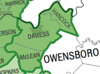
Common name: Owensboro Metro, Tri-State AreaLargest city Owensboro Other cities - Hawesville
- SacramentoPopulation - Total 113,636 (2009) Area 931 sq. mi.
2410 km²State(s) Kentucky Elevation - Highest point 580 feet (175 m) - Lowest point 355 feet (109 m) The Owensboro Metropolitan Statistical Area, as defined by the United States Census Bureau, is an area consisting of three counties in Kentucky, anchored by the city of Owensboro. As of the 2000 census, the MSA had a population of 109,875 In the 2010 Census the population was 114,752. Owensboro is more closely defined as a part of Kentuckiana than the neighboring Evansville Metropolitan Area even though at present all three counties are in Kentucky. The reason for this is that the primary city, Owensboro sits on the Ohio River directly across from Spencer County, Indiana, which is likely to become the fourth county in the metropolitan area. Perry County is also like to become part of the area as well.
Contents
Possibilities for expansion and combination
There is a chance that the Owensboro and Evansville Metros could become the Evansville-Owensboro, IL-IN-KY Combined Statistical Area in 2010, further decreasing the use of Kentuckiana as a definition, as travel time decreases and interaction increases with improved infrastructure between the two areas and many of the micropolitan areas to the north and south like the new U.S. 231 Corridor and the expansion of the 6-lane Lloyd Expressway as well as the interaction between Owensboro and Henderson along the Audubon Parkway.
 Zoom out of the Owensboro Metropolitan Area. Notice the interaction and closeness of the Evansville Metropolitan Area and the counties influenced by both areas. The Owensboro Metropolitan area is located on the right. Spencer County, Indiana (white above Owensboro) is almost completely surrounded by the two metropolitan areas.
Counties
Communities
Incorporated places
- Calhoun
- Hawesville
- Island
- Lewisport
- Livermore
- Owensboro (Principal city)
- Sacramento
- Whitesville
Census-designated places
Note: Census-designated places are unincorporated.
Demographics
As of the census[1] of 2000, there were 109,875 people, 43,232 households, and 30,142 families residing within the MSA. The racial makeup of the MSA was 94.46% White, 3.72% African American, 0.15% Native American, 0.37% Asian, 0.02% Pacific Islander, 0.41% from other races, and 0.87% from two or more races. Hispanic or Latino of any race were 0.90% of the population.
The median income for a household in the MSA was $34,467, and the median income for a family was $41,240. Males had a median income of $33,012 versus $21,659 for females. The per capita income for the MSA was $17,136.
See also
References
- ^ "American FactFinder". United States Census Bureau. http://factfinder.census.gov. Retrieved 2008-01-31.
Categories:


Wikimedia Foundation. 2010.