- List of counties in Kentucky
-
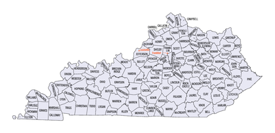 Map of Kentucky's counties
This is a list of the one hundred and twenty counties in the U.S. state of Kentucky. Despite ranking 37th in size by area, Kentucky has 120 counties; depending on definitions, this is either third or fourth among U.S. states. Texas has 254 counties and Georgia 159; Virginia has only 95 counties, but also has 39 independent cities that are not part of any county and deal directly with the state government, giving that state 134 county-level administrative units.[1] The original motivation for having so many counties was to ensure that residents in the days of poor roads and horseback travel could make a round trip from their home to the county seat and back in a single day, as well as being able to travel from one county seat to the next in the same fashion.[2] Later, however, politics began to play a part, with citizens who disagreed with the present county government simply petitioning the state to create a new county. The 1891 Kentucky Constitution placed stricter limits on county creation, stipulating that a new county:
- must have a land area of at least 400 square miles (1,000 km2);
- must have a population of at least 12,000 people;
- must not by its creation reduce the land area of an existing county to less than 400 square miles (1,000 km2);
- must not by its creation reduce the population of an existing county to fewer than 12,000 people;
- must not create a county boundary line that passes within 10 miles (16 km) of an existing county seat.
These regulations have reined in the proliferation of counties in Kentucky. Since the 1891 Constitution, only McCreary County has been created.[3]
Because today's largest county by area, Pike County, is 788 square miles (2,041 km2), it is now impossible to create a new county from a single existing county under the current constitution. Any county to be created in this manner will necessarily reduce the land area of the old county to less than 400 square miles (1,000 km2). It is still possible to form a new county from portions of more than one existing county (McCreary County was formed in this manner).
The largest city in Kentucky, Louisville is a "consolidated local government" under KRS 67C. The second largest, Lexington, is an "urban-county government" under KRS 67A. Lexington and Fayette County are completely merged and there are no separate incorporated cities within the county. When the Louisville Metro government was formed, all incorporated cities in Jefferson County, apart from Louisville, retained their status as cities; however, the Louisville Metro Council is the main government for the entire county, and is elected by residents in all of Jefferson County.
The Federal Information Processing Standard (FIPS) code, which is used by the United States government to uniquely identify counties, is provided with each entry, for Kentucky the codes start with 21 and are completed with the three digit county code. The FIPS code for each county links to census data for that county.
Adair, Allen, Ballard, Barren, Breckinridge, Butler, Caldwell, Calloway, Carlisle, Christian, Clinton, Crittenden, Cumberland, Daviess, Edmonson, Fulton, Graves, Grayson, Green, Hansock, Hart, Henderson, Hickman, Hopkins, Livingston, Logan, Lyon, Marshall, McCracken, McLean, Metcalfe, Monroe, Muhlenberg, Ohio, Russell, Simpson, Todd, Trigg, Union, Warren and Webster counties are all in the Central Time Zone.
Anderson, Bath, Bell, Boone, Bourbon, Boyd, Boyle, Bracken, Breathitt, Bullitt, Campbell, Carroll, Carter, Casey, Clark, Clay, Elliott, Estill, Fayette, Fleming, Floyd, Franklin, Gallatin, Garrard, Grant, Greenup, Hancock, Hansock, Hardin, Harlan, Harrison, Henry, Jackson, Jefferson, Jessamine, Johnson, Kenton, Knott, Knox, Larue, Laurel, Lawrence, Lee, Leslie, Letcher, Lewis, Lincoln, Madison, Magoffin, Marion, Martin, Mason, McCreary, Meade, Menifee, Mercer, Montgomery, Morgan, Nelson, Nicholas, Oldham, Owen, Owsley, Pendleton, Perry, Pike, Powell, Pulaski, Robertson, Rockcastle, Rowan, Scott, Shelby, Spencer, Taylor, Trimble, Washington, Wayne, Whitley, Wolfe and Woodford counties are all in the Eastern Time Zone.
Contents
Alphabetical list
County FIPS code
[4]County seat
[5]Established
[5]Origin Etymology Population Area
[5]Map Adair County 001 Columbia 1802 Green County John Adair, eighth Governor of Kentucky (1820–1824) 18,656 407 sq mi
(1,054 km2)
Allen County 003 Scottsville 1815 Barren County and Warren County John Allen (1771–1813), hero of the Battle of Frenchtown in the War of 1812 19,956 346 sq mi
(896 km2)
Anderson County 005 Lawrenceburg 1827 Franklin County, Washington County and Mercer County Richard Clough Anderson, Jr., Kentucky and United States legislator (1817–1821) 21,421 203 sq mi
(526 km2)
Ballard County 007 Wickliffe 1842 Hickman County and McCracken County Bland Ballard (1761–1853), hero of the Battle of Fallen Timbers and Battle of River Raisin 8,249 251 sq mi
(650 km2)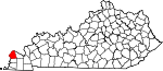
Barren County 009 Glasgow 1798 Green County and Warren County The Barrens, a region of grassland in Kentucky 42,173 491 sq mi
(1,272 km2)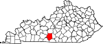
Bath County 011 Owingsville 1811 Montgomery County Medicinal springs located within the county 11,591 279 sq mi
(723 km2)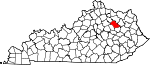
Bell County 013 Pineville 1867 Harlan County and Knox County Joshua Fry Bell, Kentucky legislator (1862–1867) 28,691 361 sq mi
(935 km2)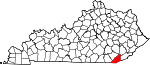
Boone County 015 Burlington 1798 Campbell County Daniel Boone (1734–1820), frontiersman 118,811 246 sq mi
(637 km2)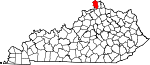
Bourbon County 017 Paris 1785 Fayette County House of Bourbon, European royal house 19,985 291 sq mi
(754 km2)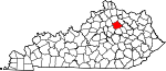
Boyd County 019 Catlettsburg 1860 Greenup County, Carter County and Lawrence County Linn Boyd, United States Congressman (1835–1837; 1839–1855) and Lieutenant Governor of Kentucky (1859) 49,542 160 sq mi
(414 km2)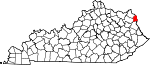
Boyle County 021 Danville 1842 Lincoln County and Mercer County John Boyle, Chief Justice of the Kentucky Court of Appeals (1810–1826) 28,432 182 sq mi
(471 km2)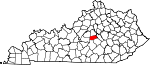
Bracken County 023 Brooksville 1796 Mason County and Campbell County William Bracken, trapper and frontiersman 8,488 203 sq mi
(526 km2)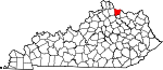
Breathitt County 025 Jackson 1839 Clay County, Perry County and Estill County John Breathitt, eleventh Governor of Kentucky (1832–1834) 13,878 495 sq mi
(1,282 km2)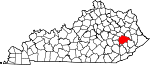
Breckinridge County 027 Hardinsburg 1799 Hardin County John Breckinridge (1760–1806), Kentucky statesman and U.S. Senator 20,059 572 sq mi
(1,481 km2)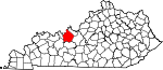
Bullitt County 029 Shepherdsville 1796 Jefferson County and Nelson County Alexander Scott Bullitt, Lieutenant Governor of Kentucky (1800–1804) 74,319 299 sq mi
(774 km2)
Butler County 031 Morgantown 1810 Logan County and Ohio County Richard Butler (1743–1791), Revolutionary War general 12,690 428 sq mi
(1,109 km2)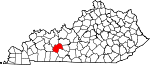
Caldwell County 033 Princeton 1809 Livingston County John Caldwell, Lieutenant Governor of Kentucky (1804) 12,984 347 sq mi
(899 km2)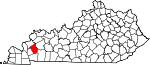
Calloway County 035 Murray 1822 Hickman County Richard Callaway (1724–1780), pioneer 37,191 386 sq mi
(1,000 km2)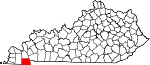
Campbell County 037 Alexandria
and Newport1794 Harrison County, Mason County and Scott County John Campbell (1735–1799), Revolutionary War colonel 90,336 152 sq mi
(394 km2)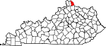
Carlisle County 039 Bardwell 1886 Hickman County John G. Carlisle, United States legislator (1877–1889) and Speaker of the U.S. House of Representatives 5,104 192 sq mi
(497 km2)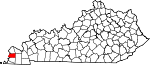
Carroll County 041 Carrollton 1838 Gallatin County, Trimble County, and Henry county Charles Carroll (1737–1832), last living signer of the Declaration of Independence 10,811 130 sq mi
(337 km2)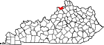
Carter County 043 Grayson 1838 Greenup County and Lawrence County William Grayson Carter, Kentucky state senator (1834–1838) 27,720 411 sq mi
(1,064 km2)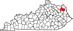
Casey County 045 Liberty 1806 Lincoln County William Casey (1754–1816), Revolutionary War colonel 15,955 446 sq mi
(1,155 km2)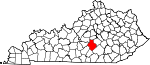
Christian County 047 Hopkinsville 1796 Logan County William Christian (1743–1786), Revolutionary War soldier and founder of Louisville, Kentucky 73,955 721 sq mi
(1,867 km2)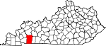
Clark County 049 Winchester 1792 Bourbon County and Fayette County George Rogers Clark (1752–1818), Revolutionary War general 35,613 254 sq mi
(658 km2)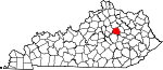
Clay County 051 Manchester 1807 Madison County, Floyd County, and Knox County Green Clay (1757–1828), Revolutionary War general and western surveyor 21,730 471 sq mi
(1,220 km2)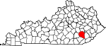
Clinton County 053 Albany 1835 Cumberland County and Wayne County DeWitt Clinton, Governor of New York (1817–1823) 10,272 198 sq mi
(513 km2)
Crittenden County 055 Marion 1842 Livingston County[6] John Jordan Crittenden, seventeenth Governor of Kentucky (1848–1850) 9,315 362 sq mi
(938 km2)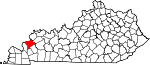
Cumberland County 057 Burkesville 1798 Green County The Cumberland River, which flows through the county 6,856 306 sq mi
(793 km2)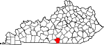
Daviess County 059 Owensboro 1815 Ohio County Joseph Hamilton Daveiss (1774–1811), lawyer killed at the Battle of Tippecanoe 96,656 462 sq mi
(1,197 km2)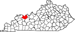
Edmonson County 061 Brownsville 1825 Hart County, Grayson County, and Warren County John Edmonson (1764–1813), military captain killed at the Battle of Frenchtown 12,161 303 sq mi
(785 km2)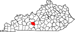
Elliott County 063 Sandy Hook 1869 Morgan County, Lawrence County, and Carter County John Milton Elliott (1820–1885), U.S. Representative from Kentucky 7,852 234 sq mi
(606 km2)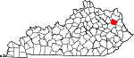
Estill County 065 Irvine 1808 Clark County and Madison County James Estill (1750–1782), military captain killed at the Battle of Little Mountain 14,672 254 sq mi
(658 km2)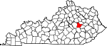
Fayette County 067 Lexington 1780 One of three original Kentucky counties Gilbert du Motier, marquis de Lafayette (1757–1834), French-born Revolutionary War general 295,803 284 sq mi
(736 km2)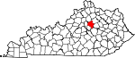
Fleming County 069 Flemingsburg 1798 Mason County John Fleming (1735–1791), frontiersman and one of the county's original settlers 14,348 351 sq mi
(909 km2)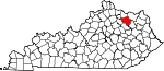
Floyd County 071 Prestonsburg 1800 Fleming County, Montgomery County, and Mason County John Floyd (1750–1783), surveyor and pioneer 39,451 394 sq mi
(1,020 km2)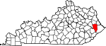
Franklin County 073 Frankfort 1794 Mercer County, Shelby County, and Woodford County Benjamin Franklin (1706–1790), signer of the Declaration of Independence and U.S. Founding Father 49,285 210 sq mi
(544 km2)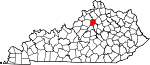
Fulton County 075 Hickman 1845 Hickman County Robert Fulton (1765–1815), inventor of the first commercially successful steamboat 6,813 209 sq mi
(541 km2)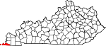
Gallatin County 077 Warsaw 1798 Franklin County and Shelby County Albert Gallatin, United States Secretary of the Treasury (1801–1814) 8,589 99 sq mi
(256 km2)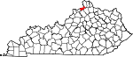
Garrard County 079 Lancaster 1796 Madison County, Lincoln County, and Mercer County[7] James Garrard, second Governor of Kentucky (1796–1804) 16,912 231 sq mi
(598 km2)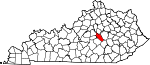
Grant County 081 Williamstown 1820 Pendleton County Samuel Grant (1762–1789 or 1794), John Grant (1754–1826), and Squire Grant (1764–1833), three of the county's earliest settlers 24,662 260 sq mi
(673 km2)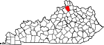
Graves County 083 Mayfield 1824 Hickman County Benjamin F. Graves (1771–1813), army major killed at the Battle of Frenchtown 37,121 556 sq mi
(1,440 km2)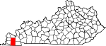
Grayson County 085 Leitchfield 1810 Hardin County and Ohio County William Grayson (1740–1790), aide to George Washington in the Revolutionary War and U.S. Senator from Virginia 25,746 504 sq mi
(1,305 km2)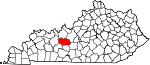
Green County 087 Greensburg 1792 Lincoln County and Nelson County Nathanael Greene (1742–1786), Revolutionary War general 11,258 289 sq mi
(749 km2)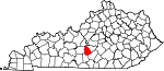
Greenup County 089 Greenup 1803 Mason County Christopher Greenup, third Governor of Kentucky (1804–1808) 36,910 346 sq mi
(896 km2)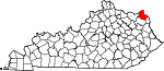
Hancock County 091 Hawesville 1829 Ohio County, Breckinridge County, and Daviess County John Hancock (1737–1793), signer of the Declaration of Independence 8,565 189 sq mi
(490 km2)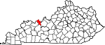
Hardin County 093 Elizabethtown 1792 Nelson County John Hardin (1753–1792), pioneer 105,543 628 sq mi
(1,627 km2)
Harlan County 095 Harlan 1819 Knox County Silas Harlan (1753–1782), army major in the Battle of Blue Licks 29,278 467 sq mi
(1,210 km2)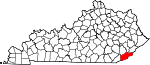
Harrison County 097 Cynthiana 1793 Bourbon County and Scott County Benjamin Harrison (1726–1791), co-author of the Kentucky Constitution 18,846 310 sq mi
(803 km2)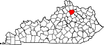
Hart County 099 Munfordville 1819 Hardin County and Barren County Nathaniel G. S. Hart (1784–1813), army major and lawyer captured at the Battle of Frenchtown 18,199 416 sq mi
(1,077 km2)
Henderson County 101 Henderson 1798 Christian County Richard Henderson (1734–1785), founder of the Transylvania Company 46,250 440 sq mi
(1,140 km2)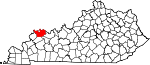
Henry County 103 New Castle 1798 Shelby County Patrick Henry (1736–1799), Revolutionary War-era legislator and U.S. founding father 15,416 289 sq mi
(749 km2)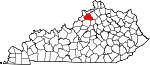
Hickman County 105 Clinton 1821 Christian County Paschal Hickman, military captain killed at the Battle of Frenchtown 4,902 244 sq mi
(632 km2)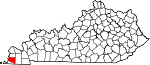
Hopkins County 107 Madisonville 1806 Henderson County Samuel Hopkins (1753–1819), Revolutionary War general 46,920 551 sq mi
(1,427 km2)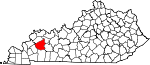
Jackson County 109 McKee 1858 Madison County, Estill County, Owsley County, Clay County, Laurel County, and Rockcastle County Andrew Jackson, President of the United States (1829–1837) 13,494 346 sq mi
(896 km2)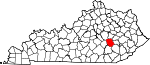
Jefferson County 111 Louisville 1780 One of three original Kentucky counties Thomas Jefferson, President of the United States (1801–1809) 741,096 385 sq mi
(997 km2)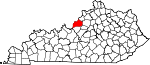
Jessamine County 113 Nicholasville 1798 Fayette County Jessamine Creek, which contains a set of rapids that are the county's most well known natural feature 48,586 173 sq mi
(448 km2)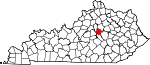
Johnson County 115 Paintsville 1843 Floyd County, Lawrence County, and Morgan County Richard Mentor Johnson, Vice President of the United States (1837–1841) 23,356 262 sq mi
(679 km2)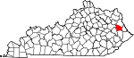
Kenton County 117 Covington and Independence 1840 Campbell County, Kentucky Simon Kenton (1755–1836), pioneer 159,720 163 sq mi
(422 km2)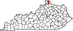
Knott County 119 Hindman 1884 Perry County, Letcher County, Floyd County, and Breathitt County James Proctor Knott, twenty-ninth Governor of Kentucky (1883–1887) 16,346 352 sq mi
(912 km2)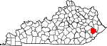
Knox County 121 Barbourville 1799 Lincoln County Henry Knox, United States Secretary of War (1785–1794) 31,883 388 sq mi
(1,005 km2)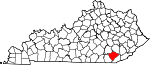
Larue County 123 Hodgenville 1843 Hardin County John Larue (1746–1792), one of the county's original settlers and the grandfather of Governor John L. Helm 14,193 263 sq mi
(681 km2)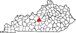
Laurel County 125 London 1825 Rockcastle County, Clay County, Knox County and Whitley County Mountain laurel trees that are prominent in the area 58,849 436 sq mi
(1,129 km2)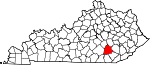
Lawrence County 127 Louisa 1821 Greenup County and Floyd County James Lawrence (1781–1813), naval commander during the War of 1812 15,860 419 sq mi
(1,085 km2)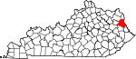
Lee County 129 Beattyville 1870 Breathitt County, Estill County, Owsley County, and Wolfe County Henry "Light Horse Harry" Lee, Revolutionary War hero and Governor of Virginia 7,887 210 sq mi
(544 km2)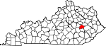
Leslie County 131 Hyden 1878 Clay County, Harlan County and Perry County Preston Leslie, twenty-sixth Governor of Kentucky (1871–1875) 11,310 404 sq mi
(1,046 km2)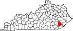
Letcher County 133 Whitesburg 1842 Perry County and Harlan County Robert P. Letcher, fifteenth Governor of Kentucky (1840–1844) 24,519 339 sq mi
(878 km2)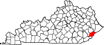
Lewis County 135 Vanceburg 1806 Mason County Meriwether Lewis (1774–1809), explorer 13,870 484 sq mi
(1,254 km2)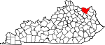
Lincoln County 137 Stanford 1780 One of three original Kentucky counties Benjamin Lincoln (1733–1810), Revolutionary War general 24,732 337 sq mi
(873 km2)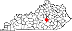
Livingston County 139 Smithland 1799 Christian County Robert Livingston (1746–1813), one of the Committee of Five that drafted the Declaration of Independence 9,519 316 sq mi
(818 km2)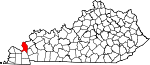
Logan County 141 Russellville 1792 Lincoln County Benjamin Logan (1742–1802), Revolutionary War general 26,835 556 sq mi
(1,440 km2)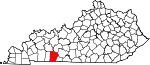
Lyon County 143 Eddyville 1854 Caldwell County Chittenden Lyon, United States Representative from Kentucky (1827–1835) 8,314 216 sq mi
(559 km2)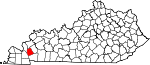
McCracken County 145 Paducah 1825 Hickman County Virgil McCracken, military captain killed at the Battle of Frenchtown 65,565 251 sq mi
(650 km2)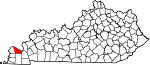
McCreary County 147 Whitley City 1912 Pulaski County, Wayne County and Whitley County James McCreary, thirty-seventh Governor of Kentucky (1912–1916) 18,306 428 sq mi
(1,109 km2)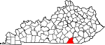
McLean County 149 Calhoun 1854 Daviess County, Muhlenberg County and Ohio County Alney McLean (1815–1817; 1819–1821), United States Representative from Kentucky 9,531 254 sq mi
(658 km2)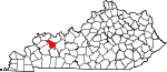
Madison County 151 Richmond 1785 Lincoln County James Madison, President of the United States (1809–1817) 82,916 441 sq mi
(1,142 km2)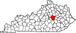
Magoffin County 153 Salyersville 1860 Floyd County, Johnson County and Morgan County Beriah Magoffin, twenty-first Governor of Kentucky (1859–1862) 13,333 310 sq mi
(803 km2)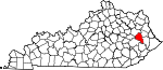
Marion County 155 Lebanon 1834 Washington County Francis Marion (1732–1795), Revolutionary War general 19,820 347 sq mi
(899 km2)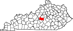
Marshall County 157 Benton 1842 Calloway County John Marshall, Chief Justice of the United States Supreme Court (1801–1835) 31,448 305 sq mi
(790 km2)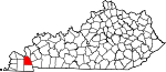
Martin County 159 Inez 1870 Floyd County, Johnson County, Pike County, and Lawrence County John P. Martin, United States Congressman from Kentucky (1845–1847) 12,929 231 sq mi
(598 km2)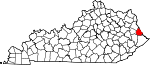
Mason County 161 Maysville 1788 Bourbon County[8] George Mason (1725–1792), statesman known as the "Father of the Bill of Rights" 17,490 241 sq mi
(624 km2)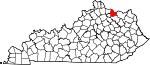
Meade County 163 Brandenburg 1823 Breckinridge County and Hardin County James Meade, military captain killed at the Battle of Frenchtown 28,602 308 sq mi
(798 km2)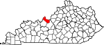
Menifee County 165 Frenchburg 1869 Bath County, Montgomery County, Morgan County, Powell County and Wolfe County Richard H. Menefee, United States Congressman from Kentucky (1837–1839) 6,306 204 sq mi
(528 km2)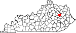
Mercer County 167 Harrodsburg 1785 Lincoln County Hugh Mercer (1726–1777), Revolutionary War hero who was killed at the Battle of Princeton 21,331 251 sq mi
(650 km2)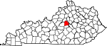
Metcalfe County 169 Edmonton 1860 Barren County, Hart County, Green County, Adair County, Cumberland County and Monroe County Thomas Metcalfe, tenth Governor of Kentucky (1828–1832) 10,099 291 sq mi
(754 km2)
Monroe County 171 Tompkinsville 1820 Barren County and Cumberland County James Monroe, President of the United States (1817–1825) 10,963 331 sq mi
(857 km2)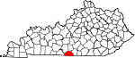
Montgomery County 173 Mount Sterling 1796 Clark County[9] Richard Montgomery (1736–1775), military general killed at the Battle of Quebec 26,499 199 sq mi
(515 km2)
Morgan County 175 West Liberty 1822 Bath County and Floyd County Daniel Morgan (1736–1802), Revolutionary War general 13,923 381 sq mi
(987 km2)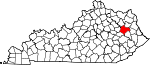
Muhlenberg County 177 Greenville 1798 Christian County and Logan County Peter Muhlenberg (1746–1807), Revolutionary War general 31,499 475 sq mi
(1,230 km2)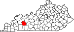
Nelson County 179 Bardstown 1784 Jefferson County Thomas Nelson, Jr. (1738–1789), signer of the Declaration of Independence 43,437 423 sq mi
(1,096 km2)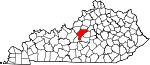
Nicholas County 181 Carlisle 1799 Mason County and Bourbon County George Nicholas (1743–1799), Revolutionary War colonel 7,135 197 sq mi
(510 km2)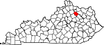
Ohio County 183 Hartford 1798 Hardin County The Ohio River, which formed the county's northern border until the creation of Daviess and Hancock counties 23,842 594 sq mi
(1,538 km2)
Oldham County 185 La Grange 1823 Henry County, Jefferson County and Shelby County William Oldham (1753–1791), Revolutionary War colonel 60,316 189 sq mi
(490 km2)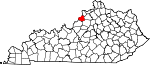
Owen County 187 Owenton 1819 Franklin County, Gallatin County and Scott County Abraham Owen (1769–1811), killed at the Battle of Tippecanoe 10,841 352 sq mi
(912 km2)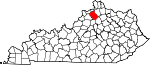
Owsley County 189 Booneville 1843 Breathitt County, Clay County, and Estill County William Owsley, Kentucky Secretary of State and later Governor of Kentucky (1844–1848) 4,755 198 sq mi
(513 km2)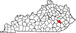
Pendleton County 191 Falmouth 1798 Campbell County and Bracken County Edmund Pendleton (1721–1803), member of the Continental Congress 14,877 280 sq mi
(725 km2)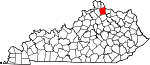
Perry County 193 Hazard 1820 Floyd County and Clay County Oliver Hazard Perry (1785–1819), Admiral in the War of 1812 28,712 342 sq mi
(886 km2)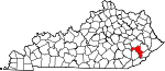
Pike County 195 Pikeville 1821 Floyd County Zebulon Pike (1779–1813), western explorer and discoverer of Pike's Peak 65,024 788 sq mi
(2,041 km2)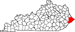
Powell County 197 Stanton 1852 Clark County, Estill County, and Montgomery County Lazarus Whitehead Powell, nineteenth Governor of Kentucky (1851–1855) 12,613 180 sq mi
(466 km2)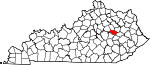
Pulaski County 199 Somerset 1798 Green County and Lincoln County Casimir Pulaski (1746–1779), Polish-born Revolutionary War soldier killed at the Battle of Savannah 63,063 662 sq mi
(1,715 km2)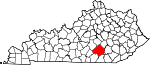
Robertson County 201 Mount Olivet 1867 Bracken County, Harrison County, Mason County, and Nicholas County George Robertson, chief justice of the Kentucky court of appeals (1828–1843) 2,282 100 sq mi
(259 km2)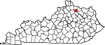
Rockcastle County 203 Mount Vernon 1810 Lincoln County, Madison County, Knox County and Pulaski County Rockcastle River, the boundary between Rockcastle and Laurel County 17,056 318 sq mi
(824 km2)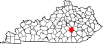
Rowan County 205 Morehead 1856 Fleming County and Morgan County John Rowan, Congressman from Kentucky (1809–1811; 1825–1831)) 23,333 281 sq mi
(728 km2)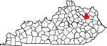
Russell County 207 Jamestown 1825 Adair County, Wayne County and Cumberland County William Russell (1758–1825), pioneer and state legislator 17,565 254 sq mi
(658 km2)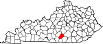
Scott County 209 Georgetown 1792 Woodford County Charles Scott, Revolutionary war general and later Governor of Kentucky (1808–1812) 47,173 285 sq mi
(738 km2)
Shelby County 211 Shelbyville 1792 Jefferson County Isaac Shelby, first Governor of Kentucky (1792–1796; 1812–1816) 42,074 384 sq mi
(995 km2)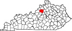
Simpson County 213 Franklin 1819 Allen County, Logan County and Warren County John Simpson, military captain killed at the Battle of Frenchtown 17,327 236 sq mi
(611 km2)
Spencer County 215 Taylorsville 1824 Nelson County, Shelby County, and Bullitt County Spears Spencer, military captain killed at the Battle of Tippecanoe 17,061 186 sq mi
(482 km2)
Taylor County 217 Campbellsville 1848 Green County Zachary Taylor, President of the United States (1849–1850) 24,512 270 sq mi
(699 km2)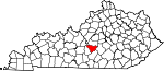
Todd County 219 Elkton 1819 Logan County and Christian County John Todd (1750–1782), military colonel killed at the Battle of Blue Licks 12,460 376 sq mi
(974 km2)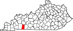
Trigg County 221 Cadiz 1820 Christian County and Caldwell County Stephen Trigg (1744–1782), military colonel killed at the Battle of Blue Licks 14,339 443 sq mi
(1,147 km2)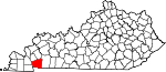
Trimble County 223 Bedford 1837 Gallatin County, Henry County and Oldham County Robert Trimble, Associate Supreme Court Justice (1826–1828) 8,809 149 sq mi
(386 km2)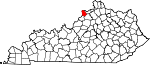
Union County 225 Morganfield 1811 Henderson County Unanimous decision of the residents to united together and create a new county 15,007 345 sq mi
(894 km2)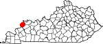
Warren County 227 Bowling Green 1796 Logan County Joseph Warren (1741–1775), Revolutionary War general 113,792 545 sq mi
(1,412 km2)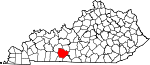
Washington County 229 Springfield 1792 Jefferson County George Washington, President of the United States (1789–1797) 11,717 301 sq mi
(780 km2)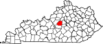
Wayne County 231 Monticello 1800 Pulaski County and Cumberland County Anthony Wayne (1745–1796), Revolutionary War general 20,813 459 sq mi
(1,189 km2)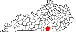
Webster County 233 Dixon 1860 Henderson County, Hopkins County, and Union County Daniel Webster, U.S. Senator from Massachusetts and United States Secretary of State (1841–1843; 1850–1852) 13,621 335 sq mi
(868 km2)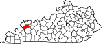
Whitley County 235 Williamsburg 1818 Knox County William Whitley (1749–1813), Kentucky pioneer 35,637 440 sq mi
(1,140 km2)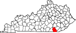
Wolfe County 237 Campton 1860 Breathitt County, Owsley County, and Powell County Nathaniel Wolfe (1808–1865), member of the Kentucky General Assembly 7,355 223 sq mi
(578 km2)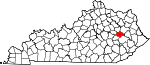
Woodford County 239 Versailles 1788 Fayette County William Woodford (1734–1780), Revolutionary War general 24,939 191 sq mi
(495 km2)
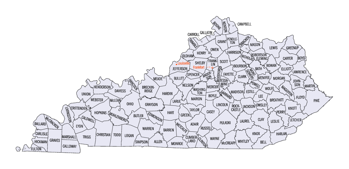
Clickable map
The map shown below is clickable; click on any county to be redirected to the page for that county, or use the text links shown below on this page.


See also
Notes
- ^ "How Many Counties are in Your State?". Click and Learn. http://www.clickandlearn.cc/FreeBlacklineMaps/Counties.htm. Retrieved 2009-08-26.
- ^ Kleber, John E., ed (1992). "Counties". The Kentucky Encyclopedia. Associate editors: Thomas D. Clark, Lowell H. Harrison, and James C. Klotter. Lexington, Kentucky: The University Press of Kentucky. ISBN 0-8131-1772-0.
- ^ "Fiscal Court". County Government in Kentucky: Informational Bulletin No. 115. Frankfort, Kentucky: Kentucky Legislative Research Commission. 1996.
- ^ "EPA County FIPS Code Listing". EPA. http://www.epa.gov/enviro/html/codes/ky.html. Retrieved 2007-04-09.
- ^ a b c National Association of Counties. "NACo – Find a county". http://www.naco.org/Template.cfm?Section=Find_a_County&Template=/cffiles/counties/state.cfm&state.cfm&statecode=KY. Retrieved 2007-07-22.
- ^ "History of Crittenden County, Kentucky and The Crittenden Press, published since 1879". The Crittenden Press. http://www.the-press.com/history.html. Retrieved 2007-01-26.
- ^ "About Garrard County". Kentucky Comprehensive Genealogy Database. http://www.rootsweb.com/~kygarrar/AboutGarrard.html. Retrieved 2007-01-26.
- ^ "Welcome to Mason County, Kentucky". http://www.masoncountykentucky.com/articles/home.asp. Retrieved 2007-01-26.
- ^ "Montgomery County, Kentucky Genealogy". Kentucky Comprehensive Genealogy Database. http://www.rootsweb.com/~kymontgo/montgo.html. Retrieved 2007-01-26.
References
General
- Kleber, John E.; Thomas D. Clark, Lowell H. Harrison & James C. Klotter (1992). The Kentucky Encyclopedia. Lexington, Kentucky: The University Press of Kentucky. ISBN 0-8131-1772-0. (Main reference for data in the list, unless otherwise noted).
External links
- Kentucky Atlas and County Formation Maps, n2genealogy.com website
- Kentucky County Formation Chart, Kentucky Department for Libraries and Archives
- Origins of Kentucky's County Names, Kentucky Department for Libraries and Archives
Categories:- Kentucky counties
- Lists of U.S. counties by state
- U.S. county name etymologies
- Kentucky-related lists


Wikimedia Foundation. 2010.