- Oldham County, Kentucky
-
Oldham County, Kentucky 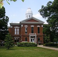 Oldham County courthouse in La Grange, Kentucky.
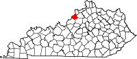
Location in the state of Kentucky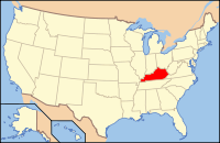
Kentucky's location in the U.S.Founded 1824 Named for William Oldham (1753–1791), American Revolutionary War colonel. Seat La Grange Area
- Total
- Land
- Water
196.54 sq mi (509 km²)
189.19 sq mi (490 km²)
7.36 sq mi (19 km²), 3.74%PopulationEst.
- (2010)
- Density
60,316
244/sq mi (94/km²)Time zone Eastern: UTC-5/-4 Website www.oldhamcounty.net Oldham County is a county located in the commonwealth of Kentucky. The population was 60,316 in the 2010 Census. Its county seat is La Grange.[1] The county is named for Colonel William Oldham. Oldham County was a prohibition or completely dry county until January 2005 as the result of a 2004 'moist' vote, permitting sales of alcohol in restaurants that seat at least 100 patrons in which 70%+ of total revenue is derived from sales of food. It is part of the Louisville/Jefferson County, KY–IN Metropolitan Statistical Area.
Oldham County is the wealthiest county in Kentucky and 48th wealthiest county in the U.S. and ranks second highest in Kentucky for percent of college educated residences. While the causes for this are complicated, areas east of Louisville have long been popular with wealthy residents, first as summer residences eventually as year-round suburban estates and bedroom communities. Oldham County lies northeast of the best known of these areas, Anchorage, just outside of Louisville's East End, and is a location of choice for Louisvillians who can afford it.
Contents
History
Oldham County was established on December 15, 1823 from parts of Henry, Jefferson, and Shelby Counties. It was the 74th Kentucky county, and was named in honor of Col. William Oldham of Jefferson County, a Revolutionary War officer.
Initially, it was mainly a rural country with small, scattered developments in places like Westport which was founded in 1800 and served as the county seat early on. When the Louisville and Frankfort Railroad Company introduced rail lines in the area in the 1850s, many new towns and communities sprang up. Eventually the railroad ceased operating as a form of public transportation, but the more rural nature of the county continued to draw residents away from the metropolitan areas in Jefferson County. Since the early 1970s and the completion of Interstate 71, which connects Oldham County to Downtown Louisville and shopping in Eastern Jefferson County, Oldham County has increasingly become suburban in nature, a natural extension of Louisville's wealthy East End as it ran out of large tracts of undeveloped land.
Now although Oldham County is the richest county in Kentucky, crime rates have risen 47% between 2000–2008, this is due to increased arrests for possession of Methamphetamine. However, crime rates in the county are still low relative to the rest of the state and surrounding areas.
Geography
According to the 2000 census, the county has a total area of 196.54 square miles (509.0 km2), of which 189.19 square miles (490.0 km2) (or 96.26%) is land and 7.36 square miles (19.1 km2) (or 3.74%) is water.[2] It is the 13th smallest county in Kentucky.
Adjacent counties
- Clark County, Indiana (northwest, across the Ohio River)
- Trimble County (northeast)
- Henry County (east)
- Shelby County (southeast)
- Jefferson County (southwest)
Demographics
 Graph of Oldham County population over time
Historical populations Census Pop. %± 1830 9,588 — 1840 7,380 −23.0% 1850 7,629 3.4% 1860 7,283 −4.5% 1870 9,027 23.9% 1880 7,667 −15.1% 1890 6,754 −11.9% 1900 7,078 4.8% 1910 7,248 2.4% 1920 7,689 6.1% 1930 7,402 −3.7% 1940 10,716 44.8% 1950 11,018 2.8% 1960 13,388 21.5% 1970 14,687 9.7% 1980 27,795 89.2% 1990 43,455 56.3% 2000 46,178 6.3% 2010 60,316 30.6% Oldham County, KY census figures As of the census[3] of 2000, there were 46,178 people, 14,856 households, and 12,196 families residing in the county. The population density was 244 per square mile (94 /km2). There were 15,541 housing units at an average density of 82 per square mile (32 /km2). The racial makeup of the county was 93.62% White, 4.21% Black or African American, 0.21% Native American, 0.44% Asian, 0.01% Pacific Islander, 0.55% from other races, and 0.97% from two or more races. 1.30% of the population were Hispanic or Latino of any race.
There were 14,856 households out of which 44.10% had children under the age of 18 living with them, 71.50% were married couples living together, 7.80% had a female householder with no husband present, and 17.90% were non-families. 14.90% of all households were made up of individuals and 4.80% had someone living alone who was 65 years of age or older. The average household size was 2.85 and the average family size was 3.17.
The age distribution was 27.40% under the age of 18, 6.90% from 18 to 24, 33.10% from 25 to 44, 25.60% from 45 to 64, and 7.00% who were 65 years of age or older. The median age was 37 years. For every 100 females there were 114.00 males. For every 100 females age 18 and over, there were 117.90 males.
The median income for a household in the county was $70,171 (2005), and the median income for a family was $70,495. Males had a median income of $46,962 versus $28,985 for females. The per capita income for the county was $25,374. About 2.90% of families and 4.10% of the population were below the poverty line, including 4.50% of those under age 18 and 6.00% of those age 65 or over. Oldham County is the most affluent county in the state of Kentucky; most residents work in Louisville and choose to live in Oldham County due to the lack of crime and the nationally recognized school system. South Oldham High School in particular, is ranked very highly among state high schools, having been named a national blue ribbon school of excellence. 2006 classes at Oldham County High School were reported as 1-15, but that number does not accurately reflect the ratio of a normal class. That number includes, e.g., the small classes of 5-6 students in Behavioral Disorders. The published ratio also includes small classes at the County Career Center, which is located on the same campus. The actual teacher-student ratios are closer to 1-30. Regardless of population sweeling and diminishing student-teacher ratios, which have led to a slight decline as of late, Oldham county is still widely recognized as the best public school system in the state.
Population growth
Currently the population of Oldham County is rapidly expanding as adjacent urban Jefferson County is running out of space for new suburban-style development. Currently the population is increasing at about 4% per year. At current rates of growth, the number of residents will double every 21 years. Over the period from 1960 to 2000, the population increased 245% (in the same period, Jefferson County only increased 13.5%). At the current rate, Oldham County will have a population around 61,000 by 2010.
Economy
Oldham County's efforts to build a large business park on nearly 1,000 acres (4.0 km2) of vacant land could have a significant, positive impact on the community, according to an economic analysis conducted by University of Louisville economist Paul Coomes.
The study, commissioned by the Oldham County Economic Development Authority (OCEDA) and Oldham-La Grange Development Authority, found that thousands of jobs and millions of dollars in salaries would be created if the plan to fully develop the Oldham Reserve Business Park in La Grange comes to fruition. The plan calls for development of mixed-use commercial buildings such as office and retail on nearly 1,000 acres (4.0 km2) of land that was acquired in August 2005 by OCEDA for nearly $10 million.
So far, the park has lured one major tenant, The Rawlings Group. The company, which provides claims-recovery services for insurance companies, relocated its headquarters to the park from downtown Louisville in October 2007. The Rawlings Group built a 156,000-square-foot (14,500 m2) office building, where it expects to ultimately employ more than 500 workers.
Commerce
Oldham County is home to many small businesses.
Cities, towns and census-designated places
- Ballardsville
- Brownsboro
- Buckner
- Centerfield
- Crestwood
- Floydsburg
- Goshen
- La Grange
- Orchard Grass Hills
- Park Lake
- Pewee Valley
- Prospect
- River Bluff
- Westport
See also
- Louisville-Jefferson County, KY-IN Metropolitan Statistical Area
- Louisville-Elizabethtown-Scottsburg, KY-IN Combined Statistical Area
- Moist county
- National Register of Historic Places listings in Oldham County, Kentucky
- The Oldham Era
References
- ^ "Find a County". National Association of Counties. http://www.naco.org/Counties/Pages/FindACounty.aspx. Retrieved 2011-06-07.
- ^ "Census 2000 U.S. Gazetteer Files: Counties". United States Census. http://www.census.gov/tiger/tms/gazetteer/county2k.txt. Retrieved 2011-02-13.
- ^ "American FactFinder". United States Census Bureau. http://factfinder.census.gov. Retrieved 2008-01-31.
External links
Municipalities and communities of Oldham County, Kentucky Cities CDP Unincorporated
communitiesBallardsville | Brownsboro | Centerfield | Floydsburg
Categories:- Kentucky counties
- Oldham County, Kentucky
- Ohio River counties
- Louisville metropolitan area


Wikimedia Foundation. 2010.