- Charlton-on-Otmoor
-
Coordinates: 51°50′24″N 1°11′02″W / 51.840°N 1.184°W
Charlton-on-Otmoor 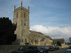
St Mary's parish church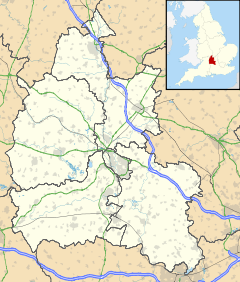
 Charlton-on-Otmoor
Charlton-on-Otmoor shown within OxfordshirePopulation 426 (2001 census)[1] OS grid reference SP5615 Parish Charlton-on-Otmoor District Cherwell Shire county Oxfordshire Region South East Country England Sovereign state United Kingdom Post town Kidlington Postcode district OX5 Dialling code 01865 Police Thames Valley Fire Oxfordshire Ambulance South Central EU Parliament South East England UK Parliament Henley Website Otmoor: Charlton-on-Otmoor List of places: UK • England • Oxfordshire Charlton-on-Otmoor is a village and civil parish about 4 miles (6.4 km) south of Bicester in Oxfordshire, England. The village is close to the River Ray on the northern edge of Otmoor.
Contents
Church and chapels
Church of England
Charlton had a parish church by the 11th century.[2] The present Church of England parish church of Saint Mary the Virgin was a 13th century Early English Gothic building but received substantial Decorated Gothic alterations in the 14th century. The east window is slightly later, in the transitional style from Decorated to Perpendicular Gothic. Around the beginning of the 16th century the clerestory and new roof were added to the nave and a new window was added to the south aisle.[3]
In the early 16th century the present rood screen and rood loft (for a crucifix between the chancel and nave) were added to the church. During the English Reformation Edward VI's injunctions of 1547 instructed that rood screens and lofts be removed be removed from all churches in England and Wales. Charlton's screen and loft survived these injunctions, and in the 20th century the critic Jennifer Sherwood judged them "the finest and most complete in the county".[4] A tradition of garlanding the rood cross with flowers and box greenery on May Day and carrying it in procession around the parish also survived the Reformation and continues in modern times.[2]
In 1846 the Gothic Revival architect G.E. Street re-roofed the church and restored the north wall. In 1889 the rood screen and loft were restored.[2] St. Mary's has never been over-restored, and its Decorated and Perpendicular mediaeval character has survived almost intact.
By 1553 the bell tower had five bells[2] plus a Sanctus bell,[5] but all have since been recast or replaced. Richard Keene, whose foundries included one at Woodstock,[6] cast the two largest bells in 1681.[7] Thomas Lester of the Whitechapel Bell Foundry[6] cast another bell in 1746[7] and Matthew II Bagley of Chacombe, Northamptonshire cast another in 1755. The then treble bell broke in 1789[5] but John Warner and Sons of the Whitechapel Bell Foundry recast it that same year.[7] In the 19th century the Bagley bell survived for a long time with a fracture, but in 1895 its tongue and head fell out.[5] Mears and Stainbank of the Whitechapel Bell Foundry replaced or recast the broken bell in 1898.[7] In 1998 the Whitechapel Bell Foundry cast a new treble bell,[7] making the 1789 bell the second bell and increasing the tower to a ring of six bells. In 1999 the new bell was hung and the old bells re-hung as a project for the village to celebrate the Millennium.[5] John Warner and Sons cast the present Sanctus bell in 1793.[7]
St. Mary's is now part of the Church of England Benefice of the Ray Valley.[8]
Baptist and Methodist chapels
Charlton had a Baptist meeting house by 1810 and a new Baptist chapel in 1835. The village had a Methodist congregation by 1829 which built a new chapel in 1840. The Methodist chapel had ceased to be used by the end of the 19th century and was sold to the Church of England Rector in 1920 who converted it into a club room.[2]
Amenities
Charlton has one public house, The Crown. There was formerly another pub, the George and Dragon, a 17th-century house at the eastern end of the village. This was where locals formed the Otmoor Association in 1830, leading to the Otmoor Riots in opposition to plans to drain and enclose Otmoor. The rioters achieved their objective, and the villagers continued to farm a four-field open field system. A subsequent attempt at enclosure in 1858 was successful.[2]
The enclosure of 1858 set aside land for the building of Charlton Parochial School, which opened in 1866. The number of pupils grew and a second classroom was added in 1892. It was reorganised as a junior school in 1937 and became a voluntary controlled school in 1951.[2] It is now Charlton-on-Otmoor Church of England Primary School.[9]
Otmoor Women's Institute meets in Charlton-on-Otmoor.[10] Charlton United F.C. plays in Oxfordshire Senior Football League Division One.
Transport
The Buckinghamshire Railway between Bletchley and Oxford passes through the parish and was completed in 1851. Tthe London and North Western Railway took it over in 1879 and opened Charlton Halt, 1 mile (1.6 km) north of the village, in 1905. The 1923 Grouping made the L&NWR part of the new London, Midland and Scottish Railway, which closed Charlton Halt in 1926. The part of the line between Oxford and Bicester is now the Bicester Link. The line's nearest station to Charlton is now Islip, 2.5 miles (4 km) away.
A local bus and coach company, Charlton Services, is based in the village. Two of its routes serve Charlton:
- Route 94 which is a Monday to Saturday service between Bicester and Oxford via Arncott and Islip
- Route 95 which runs only on Mondays and Fridays between Murcott and Oxford.
References
- ^ "Area: Charlton-on-Otmoor CP (Parish): Parish Headcounts". Neighbourhood Statistics. Office for National Statistics. http://neighbourhood.statistics.gov.uk/dissemination/LeadTableView.do?a=7&b=798553&c=Charlton-on-Otmoor&d=16&e=15&g=480229&i=1001x1003x1004&o=1&m=0&r=1&s=1267789086368&enc=1&dsFamilyId=779. Retrieved 4 March 2010.
- ^ a b c d e f g Lobel, 1959, pages 80–92
- ^ Sherwood & Pevsner, 1974, pages 529–530
- ^ Sherwood & Pevsner, 1974, page 530
- ^ a b c d "Charlton-on-Otmoor". Oxford Diocesan Guild of Church Bell Ringers, Bicester Branch. http://ccgi.coledaleweb.force9.co.uk/cgi-bin/charlton.php. Retrieved 9 September 2011.
- ^ a b Dovemaster (25 June 2010). "Bell Founders". Dove's Guide for Church Bell Ringers. http://dove.cccbr.org.uk/founders.php. Retrieved 9 September 2011.
- ^ a b c d e f Baldwin, John (10 March 2005). "Charlton on Otmoor S Mary V". Dove's Guide for Church Bell Ringers. http://dove.cccbr.org.uk/detail.php?searchString=Charlton+on+Otmoor&numPerPage=10&Submit=Go&searchAmount=%3D&searchMetric=cwt&sortBy=Place&sortDir=Asc&DoveID=CHARLTONOT. Retrieved 9 September 2011.
- ^ Archbishops' Council (2010). "Benefice of the Ray Valley". A Church Near You. Church of England. http://www.achurchnearyou.com/benefice.php?B=27/412AJ. Retrieved 9 September 2011.
- ^ Charlton-on-Otmoor CE Primary School
- ^ Otmoor Women's Institute
Sources
- Lobel, Mary D, ed (1959). A History of the County of Oxford, Volume 6. Victoria County History. pp. 80–92.
- Sherwood, Jennifer; Pevsner, Nikolaus (1974). Oxfordshire. The Buildings of England. Harmondsworth: Penguin Books. pp. 529–530. ISBN 0 14 071045 0.
External links
- Charlton-on-Otmoor page from Otmoor Noticeboard website.
Categories:- Villages in Oxfordshire
- Civil parishes in Oxfordshire


Wikimedia Foundation. 2010.