Newton Purcell with Shelswell
- Newton Purcell with Shelswell
-
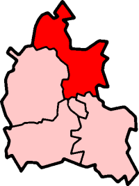
Coordinates: 51°57′54″N 1°06′04″W / 51.965°N 1.101°W / 51.965; -1.101 Newton Purcell with Shelswell is a civil parish in Oxfordshire, England. It was formed in 1932 by merger of the parishes of Newton Purcell[1] (grid reference SP6230) and Shelswell[2] (grid reference SP6030).
Sources
References
- ^ Lobel, 1959, pages 262-267
- ^ Lobel, 1959, pages 285-289
| v · Cherwell |
|
Oxfordshire • County Council elections • District Council elections
Banbury County Constituency • Oxford West and Abingdon County Constituency • Witney County Constituency |
|
| Towns |
|
 |
|
| Large Villages |
|
|
Other Civil
Parishes
(Component
Villages
and Hamlets) |
Ardley with Fewcott ( Ardley, Fewcott) • Barford St. John and St. Michael ( Barford St. Michael, Barford St. John) • Begbroke • Blackthorn • Bletchingdon (Enslow) • Bourton ( Great Bourton, Little Bourton) • Broughton • Bucknell • Charlton-on-Otmoor • Chesterton (Little Chesterton) • Claydon with Clattercot ( Claydon, Clattercote) • Cottisford (Juniper Hill) • Cropredy • Drayton • Duns Tew • Epwell • Fencott and Murcott (Fencott, Murcott) • Finmere • Fringford • Fritwell • Godington • Gosford and Water Eaton ( Gosford, Water Eaton) • Hampton Gay and Poyle (Hampton Gay, Hampton Poyle) • Hanwell • Hardwick with Tusmore (Hardwick, Tusmore) • Hethe (Willaston) • Horley • Hornton • Horton-cum-Studley • Islip • Kirtlington (Northbrook) • Lower Heyford (Caulcott) • Merton • Middle Aston • Middleton Stoney • Milcombe • Milton • Mixbury • Mollington • Newton Purcell with Shelswell ( Newton Purcell, Shelswell) • Noke • North Aston • North Newington • Oddington • Piddington • Prescote • Shenington with Alkerton ( Shenington, Alkerton) • Shipton-on-Cherwell and Thrupp ( Shipton-on-Cherwell, Thrupp) • Shutford • Sibford Ferris • Sibford Gower (Burdrop) • Somerton • Souldern • South Newington • Steeple Aston • Stoke Lyne ( Bainton) • Stratton Audley • Swalcliffe • Tadmarton • Wardington (Lower Wardington, Upper Wardington) • Wendlebury • Weston-on-the-Green • Wigginton • Wroxton ( Balscote)
|
|
Former Districts
and Boroughs |
|
|
Former
Constituencies |
|
|
| List of Parliamentary constituencies in Oxfordshire • List of places in Oxfordshire • List of civil parishes in Oxfordshire |
|
Categories:
- Oxfordshire geography stubs
- Civil parishes in Oxfordshire
Wikimedia Foundation.
2010.
Look at other dictionaries:
Newton Purcell — Coordinates: 51°58′30″N 1°05′24″W / 51.975°N 1.09°W / 51.975; 01.090 … Wikipedia
Claydon with Clattercot — Coordinates: 52°08′56″N 1°19′52″W / 52.149°N 1.331°W / 52.149; 1.331 Claydon with Clattercot is a … Wikipedia
Mixbury — Coordinates: 52°00′14″N 1°06′50″W / 52.004°N 1.114°W / 52.004; 1.114 … Wikipedia
Cottisford — Coordinates: 51°58′44″N 1°08′24″W / 51.979°N 1.140°W / 51.979; 1.140 … Wikipedia
Cropredy — Coordinates: 52°06′58″N 1°19′12″W / 52.116°N 1.320°W / 52.116; 1.320 … Wikipedia
Claydon, Oxfordshire — Coordinates: 52°08′49″N 1°19′59″W / 52.147°N 1.333°W / 52.147; 1.333 … Wikipedia
Clattercote — Coordinates: 52°08′20″N 1°19′48″W / 52.139°N 1.330°W / 52.139; 1.330 … Wikipedia
North Aston — Coordinates: 51°57′22″N 1°18′32″W / 51.956°N 1.309°W / 51.956; 1.309 … Wikipedia
Oxfordshire (UK Parliament constituency) — Oxfordshire Former County constituency for the House of Commons County Oxfordshire 1290 (1290)–1885 … Wikipedia
Oxford West and Abingdon (UK Parliament constituency) — Oxford West and Abingdon County constituency for the House of Commons Boundary of Oxford West and Abingdon in … Wikipedia