- Chew Valley
-
This article is about Chew Valley in Somerset. For Chew Valley in Saddleworth, see Chew Valley, Greater Manchester.Not to be confused with Cheu Valley.
Coordinates: 51°20′15″N 2°36′55″W / 51.337421°N 2.615197°W
Chew Valley 
 Chew Valley
Chew Valley shown within SomersetArea 182 sq mi (470 km2) Population approximately 5,000 (2001) OS grid reference ST571600 District Mendip Unitary authority Bath and North East Somerset North Somerset Ceremonial county Somerset Region South West Country England Sovereign state United Kingdom Post town BRISTOL Postcode district BS40 Post town RADSTOCK Postcode district BA3 Dialling code 01275 01761 Police Avon and Somerset Fire Avon Ambulance Great Western EU Parliament South West England UK Parliament North East Somerset List of places: UK • England • Somerset The Chew Valley is an area in North Somerset, England, named after the River Chew, which rises at Chewton Mendip, and joins the River Avon at Keynsham. Technically, the area of the valley is bounded by the water catchment area of the Chew and its tributaries; however, the name Chew Valley is often used less formally to cover other nearby areas, for example, Blagdon Lake and its environs, which by a stricter definition are part of the Yeo Valley. The valley is an area of rich arable and dairy farmland, interspersed with a number of villages.
The landscape consists of the valley of the River Chew and is generally low-lying and undulating. It is bounded by higher ground ranging from Dundry Down to the north, the Lulsgate Plateau to the west, the Mendip Hills to the south and the Hinton Blewett, Marksbury and Newton St Loe plateau areas to the east. The valley's boundary generally follows the top of scarp slopes except at the southwestern and southeastern boundaries where flat upper areas of the Chew Valley grade gently into the Yeo Valley and eastern Mendip Hills respectively. The River Chew was dammed in the 1950s to create Chew Valley Lake, which provides drinking water for the nearby city of Bristol and surrounding areas. The lake is a prominent landscape feature of the valley, a focus for recreation, and is internationally recognised for its nature conservation interest, because of the bird species, plants and insects.
The area falls into the domains of councils including: Bath and North East Somerset, North Somerset and Mendip. Part of the area falls within the Mendip Hills AONB. Most of the undeveloped area is within the Bristol/Bath Green Belt. Many of the villages date back to the time of the Domesday Book and there is evidence of human occupation since the Stone Age. There are hundreds of listed buildings with the churches being Grade I listed.
The main village is Chew Magna but the largest are Pensford, Clutton, Bishop Sutton, High Littleton and Temple Cloud
Contents
Etymology
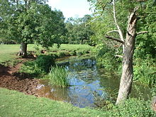 The river Chew between Stanton Drew and Pensford
There is no clear origin for the name "Chew", found scarcely anywhere else; however, there have been differing explanations of the etymology, including "winding water",[1] the 'ew' being a variant of the French eau, meaning water. The word chewer is a western dialect for a narrow passage, and chare is Old English for turning. One explanation is that the name Chew began in Normandy as Cheux, and came to England with the Norman Conquest during the eleventh century. However, others agree with Ekwall's interpretation that it is derived from the Welsh cyw meaning "the young of an animal, or chicken", so that afon Cyw would have been "the river of the chickens".[2] Other possible explanations suggest it comes from the Old English word ceo, `fish gill', used in the transferred sense of a ravine, in a similar way to Old Norse gil, or possibly a derogatory nickname from Middle English chowe `chough', Old English ceo, a bird closely related to the crow and the jackdaw, notorious for its chattering and thieving.
Government and politics
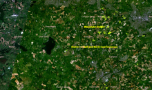 The chew valley area in a satellite image
The villages in the valley have their own parish councils which have responsibility for local issues. They also elect councillors to district councils e.g. Mendip and Somerset County Council or unitary authorities e.g. Bath and North East Somerset or North Somerset, which have wider responsibilities for services such as education, refuse, tourism etc.
Each of the villages is also part of a constituency, either North East Somerset or North Somerset).[3] The area is also of the South West England constituency of the European Parliament. Avon and Somerset Constabulary provides police services to the area.
History
Geology
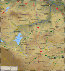 Topographical map of the Chew Valley
The western end of the area (around Nempnett Thrubwell) consists of the Harptree Beds which incorporate silicified clay, shale and Lias Limestone. Clifton Down Limestone, which includes Calcite and Dolomitic mudstones of the Carboniferous period, is found in the adjoining central band and Dolomitic Conglomerate of the Triassic period. There are two main soil types, both generally well-drained.[4] The mudstones around the lakes give rise to fertile silty clay soils that are a dull dusky red colour because of their high iron content. The clay content means that where unimproved they easily become waterlogged when wet, and hard with cracks and fissures during dry periods.[5] The main geological outcrops around the lake are Mudstone, largely consisting of red Siltstone resulting in the underlying characteristic of the gently rolling valley landscape. There are also bands of Sandstone of the Triassic period, that contribute to the undulating character of the area. There are also more recent alluvial deposits beside the course of the River Chew.[6] The transition between the gently sloping landscape of the Upper Chew and Yeo Valleys and the open landscape of the Mendip Hills plateau is a scarp slope of 75 to 235 metres (250–770 ft). The predominant formation is Dolomitic Conglomerate of the Triassic period. It formed as a result of desert erosion and weathering of the scarp slopes. It takes the form of rock fragments mainly derived from older Carboniferous Limestone cemented together by lime and sand which hardened to give the appearance of concrete.[7] The northern boundary is formed by the sides of the Dundry Plateau where the most significant geological formation is the Inferior Oolite of the Jurassic period found on the higher ground around Maes Knoll. This overlays the Lower Lias Clay found on the adjoining slopes. The clays make a poor foundation and landslips are characteristic on the slopes. This area was once connected to the Cotswolds. The intervening land has subsequently been eroded leaving this outlier with the characteristics of the Cotswold Plateau.[8] The unusual geological features have been recognised with sites including; Barns Batch Spinney,[9] Hartcliff Rocks Quarry[10] and Dundry Main Road South Quarry[11] being recognised as Sites of Special Scientific Interest (SSSI) for their geological interest.
The oldest geological formation in the valley is the Supra- Pennant Measures of the Carboniferous period. It is a significant feature towards the north-eastern part of the area and is represented by the Pensford Syncline coal basin, which formed part of the Somerset coalfield. It is a complex formation containing coal seams and is made up of clay and shales. The landscape is typically undulating and includes outcrops of sandstone. Most of the area around Stanton Drew have neutral to acid red loamy soils with slowly permeable subsoils. Soils to the eastern part of the area are slowly permeable clayey and fine silty soils. They are found on Carboniferous clay and shales typical of the Supra-Pennant Measures. They are frequently waterlogged where the topography dictates. They tend towards being acid and are brown to grey brown in colour.[6] In the south and south east of the area there are coal measures which are sufficiently near the surface for coal mining to have taken place around Clutton and High Littleton.[12] In the eastern area of the valley as the River Chew flows through Publow, Woollard and Compton Dando before joining the River Avon at Keynsham there are alluvial deposits of clay soils.
Natural history
 View of Chew Valley Lake showing Herriot's Bridge
The valley has areas designated as Site of Special Scientific Interest (SSSI) for biological interest including; Blagdon Lake,[13] Burledge Hill,[14] Chew Valley Lake,[15] Compton Martin Ochre Mine,[16] Harptree Combe[17] and two sites at Folly Farm.[18]
Flora
The small and medium-sized fields of the valley are generally bounded by hedges and occasionally by tree belts and woodland, some of which date back to the most evident period of enclosure of earlier open fields which took place in the late medieval period. Hedgerows support the nationally rare bithynian vetch (Vicia bithynica). Mature oak (Quercus) and ash (Fraxinus excelsior) trees are characteristic of the area with occasional groups of scots pine (Pinus sylvestris) and Chestnuts (Castanea sativa). Elm (Ulmus) trees have been lost in this area, and dead/dying elms are also evident in the surrounding landscape.[6]
Fauna
Wildlife abounds in the valley, particularly the water birds around the rivers and lakes, with Chew Valley Lake considered the third most important site in Britain for wintering wildfowl. In addition to the water birds including ducks, shoveler (Anas clypeata), gadwall (Anas strepera) and great crested grebes (Podiceps cristatus)[19] a wide variety of other bird species can be seen. These range from small birds such as tits (Paridae) and wrens (Troglodytidae) to Mistle Thrush (Turdidae). Larger birds include Woodpeckers (Picidae) and Common Buzzard (Buteo buteo).
The valley also has a wide variety of small mammals with larger species including; Eurasian Badger (Meles meles) and Deer (Cervidae). The valley is also home to fifteen of the sixteen bats found in England including a roost, at Compton Martin Ochre Mine, for Greater Horseshoe Bats (Rhinolophus ferrumequinum). A rare and endangered species, the greater horseshoe bat is protected under the Wildlife and Countryside Act 1981 and is listed in Annex II of the 1992 European Community Habitats Directive.[20]
Human habitation
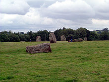 A prehistoric stone circle at Stanton Drew
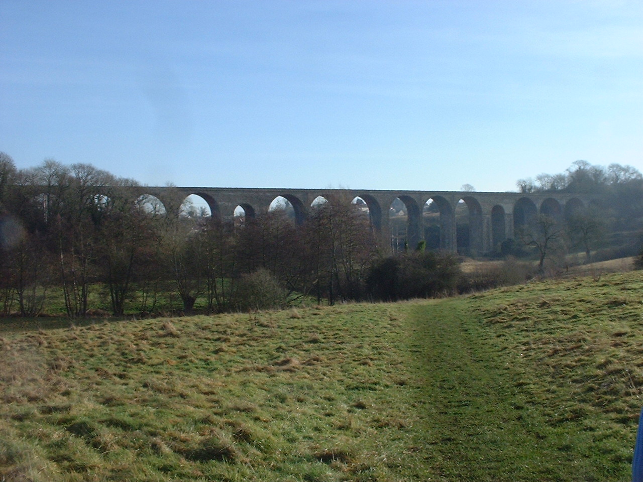
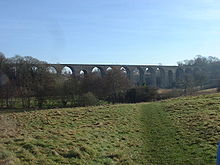 Railway viaduct at Pensford (disused)
Archaeological excavations carried out before the flooding of Chew Valley Lake found evidence of people belonging to the consecutive periods known as Upper Palaeolithic, Mesolithic and Neolithic (Old, Middle and New Stone Age), Bronze Age and Iron Age, comprising implements such as stone knives, flint blades and the head of a mace, along with buildings and graves.[21][22] Other evidence of occupation from prehistoric times is provided by the henge monument at Stanton Drew,[23] long barrow at Chewton Mendip,[24] and Fairy Toot tumulus at Nempnett Thrubwell.[25][26] Maes Knoll fort (close to Norton Malreward) in the northern reaches of the valley, on Dundry Down, also formed the starting point for Wansdyke.[27]
There is evidence of Roman remains in particular a villa and burial pits. Artefacts from the valley were sent to the British Museum. Other Roman artefacts from the lake are also on display at the Bristol City Museum and Art Gallery.[22] There are historic parks and mansion houses, including Stanton Drew, Hunstrete, Stowey House Chew Court, Chew Magna Manor House and Sutton Court. Almost all of the villages have churches dating back to the fifteenth or sixteenth Century.
The area around Pensford was an important coal mining area during the nineteenth and early twentieth centuries, with much of the coal being carried on the Somerset Coal Canal, although there are no working coal mines today. The line of the now disused North Somerset Railway runs south from Bristol crossing over the River Chew on the surviving distinctive viaduct at Pensford and on to Midsomer Norton. The area suffered serious flooding during the storm of 10 July 1968, prompting localised evacuation of populated valley areas in the lower parts of the valley, around Pensford and Keynsham.[28]
Field patterns
The small fields in the western part of the area are particularly characteristic of the Chew Valley and date back to the most evident period of enclosure of earlier open fields which took place in the late medieval period. Fields of this category are generally small in size, regular in outline and often the boundaries preserve the outlines of the earlier strip field system. Regional variations in field size and pattern do occur. For example there is evidence of medieval clearance of woodland on the slopes around Nempnett Thrubwell, south of Bishop Sutton and west and south of Chelwood.[6]
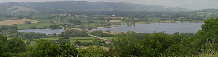
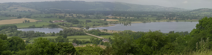
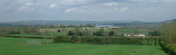 The Chew Valley as seen from East Harptree
Climate
Along with the rest of South West England, the Chew Valley has a temperate climate which is generally wetter and milder than the rest of the country.[29] The annual mean temperature is approximately 10 °C (50.0 °F). Seasonal temperature variation is less extreme than most of the United Kingdom because of the adjacent sea temperatures. The summer months of July and August are the warmest with mean daily maxima of approximately 21 °C (69.8 °F). In winter mean minimum temperatures of 1 °C (33.8 °F) or 2 °C (35.6 °F) are common.[29] In the summer the Azores high pressure affects the south-west of England, however convective cloud sometimes forms inland, reducing the number of hours of sunshine. Annual sunshine rates are slightly less than the regional average of 1,600 hours.[29] In December 1998 there were 20 days without sun recorded at Yeovilton. Most the rainfall in the south-west is caused by Atlantic depressions or by convection. Most of the rainfall in autumn and winter is caused by the Atlantic depressions, which is when they are most active. In summer, a large proportion of the rainfall is caused by sun heating the ground leading to convection and to showers and thunderstorms. Average rainfall is around 700 mm (28 in). About 8–15 days of snowfall is typical. November to March have the highest mean wind speeds, and June to August have the lightest winds. The predominant wind direction is from the south-west.[29]
Population and demographics
Many of the large houses in the valley have been built or bought by wealthy merchants from Bristol and Bath with local people working for their households.[30] Bess of Hardwick (1527–1606) is known to have lived in Sutton Court, Stowey for a few years in the sixteenth century, after the death of her first husband Sir William Cavendish, when she married Sir William St. Loe (or Sentloe or St. Lowe), captain of the guard to Queen Elizabeth, Chief Butler of England, and owner of several manors within the valley and surrounding areas.[31] Around this period a close neighbour was Sir John Popham (1533–1607) who was judge and the Speaker of Parliament.[32] In the seventeenth century John Locke (1632–1704) an eminent philosopher lived in Belluton and his house is still known as John Locke's cottage.[33] In the eighteenth century the poet John Langhorne (1735–1779) became the curate at Blagdon[34] around the time that Augustus Montague Toplady (1740–1778) was the priest, and William Smith moved to the valley to make a valuation survey of the Sutton Court estate and later for the Somersetshire Coal Canal Company.[35]
During the nineteenth century aristocrat George Lyttelton, 4th Baron Lyttelton (1817–1876) was a resident. His seat was at Chew Magna, where John Sanger, the circus proprietor, was born in 1816. William Rees-Mogg, former editor of The Times, took the title Baron Rees-Mogg, of Hinton Blewitt, but no longer lives in the village. Jazz clarinetist Acker Bilk lives in Pensford. Richard Brock the natural history film producer, Liam Fox a Conservative politician and Dr Phil Hammond a GP and comedian also live in the valley. Robert Hunter of the Grateful Dead lived in Pensford from 1979–1981.
In the past part of the population worked in coal mining, although there are no working mines in the area now. There is still a fairly large agricultural workforce and in light industry or service industries, although many people commute to surrounding cities for work. According to the 2001 Census the valley has a population of approximately 5000, largely living in one of the dozen or so villages and in isolated farms and hamlets. The average age of the population is 42 years, with unemployment rates of 1–4% of all economically active people aged 16–74, however these figures are approximations because the ward areas covered and described in the census statistics do not relate exactly to the area of the valley. In the Indices of deprivation 2004 all of the areas within the valley were considered to be in the most affluent third in England.[36][37][38][39][40][41][42][43][44]
Buildings and settlements
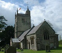 St Margaret's Church at Hinton Blewitt
The villages tend to have been built at the points where it was possible to cross the rivers and streams. Chew Magna is the business centre with a range of shops, banks etc. Other villages have local shops, often combined with post offices. Most villages have pubs and village halls which provide the majority of the social activity.
The traditional building material is white Lias Limestone; sometimes incorporating red sandstone or conglomerate, with red clay tiled roofs. Buildings, particularly the churches, date back hundreds of years, for example those at Marksbury and Compton Martin; the latter incorporating a columbarium.[45]
Listed buildings
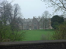 Sutton Court at Stowey
There are hundreds of listed buildings in the valley. Listing refers to a building or other structure officially designated as being of special architectural, historical or cultural significance. The authority for listing is granted by the Planning (Listed Buildings and Conservation Areas) Act 1990 and is presently administered by English Heritage, an agency of the Department for Culture, Media & Sport. Grade I covers buildings of exceptional interest, Grade II* particularly important buildings of special interest and Grade II buildings of special interest. Listed buildings in the valley number five churches dating back to the fourteenth century or even earlier, with grade I status; Church of St Andrew, Chew Magna,[46] Church of St Bartholomew, Ubley,[47] Church of St James, Cameley,[48] Church of St Margaret, Hinton Blewett[49] and the Church of St Michael the Archangel, Compton Martin.[50]
Transport
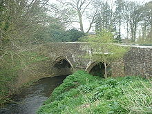 13th century bridge at Stanton Drew
At the western end of the valley is the A38 and Bristol International Airport, which means parts of the valley are on the flight path. The valley is also crossed by the A37 and they are joined by the A368. Most of the roads in the valley are small single track lanes with little traffic although a bottleneck often occurs within Chew Magna. The "Chew Valley Explorer" bus route 672/674 provides access to the villages in the valley.[51] Cyclists can gain access via part of the Padstow to Bristol West Country Way, National Cycle Network Route 3.
The Monarch's Way long distance footpath crosses the valley.[52]
Schools
Chew Valley School[53] is the main secondary school (11–18 years) for the valley. It is situated between Chew Magna and Chew Stoke. The latest (2008) Ofsted Inspection Report[54] describes this specialist Performing Arts College as a mixed comprehensive school with 1151 pupils on roll. The school is popular and oversubscribed with 196 students in the sixth form. The school has been successful in gaining a number of national and regional awards. There are state primary schools (4–11 years) in most of the local villages.
Sport and leisure facilities
The local villages have football pitches and children's play areas. Gymnasium facilities, squash courts, badminton etc., and outdoor all-weather pitches are available at the Chew Valley Leisure Centre between Chew Magna and Chew Stoke.[55] There are a range of clubs and societies for young and old, including Scout groups, gardening society, and the Women's institute. There are areas in the valley which the Countryside Agency has designated as access land; Burledge Hill (south of Bishop Sutton)(grid reference ST589590), Castle Earthworks (between Stowey and Bishop Sutton)(grid reference ST597592), Knowle Hill (Newtown south of Chew Magna)(grid reference ST583613), Round Hill (Folly Farm)(grid reference ST605608) and Shortwood Common (Litton) (grid reference ST595553)
A Bowls club is in Chew Stoke, cricket pitches and teams in Chew Magna[56] and Blagdon.[57] There are football teams in the valley including Chew Valley Football Club[58] and Bishop Sutton F.C.. The rugby club is based next to the leisure centre.[59] The Bishop Sutton Tennis club[60] is the largest in the valley, there is also a tennis club at East Harptree. Both Chew Valley Lake and Blagdon Lake provide extensive fishing under permit from Bristol Water. The River Chew and most of its tributaries also have fishing but this is generally under licences to local angling clubs. Chew Valley Sailing Club[61] is situated on Chew Valley Lake and provides dinghy sailing at all levels and hosts national and international competitions. There are no swimming pools in the valley, and swimming is not allowed in the lakes, however these are available locally in Bristol, Bath, Cheddar and Midsomer Norton.
Each year the Chew Valley Arts trail takes place in October during which over 50 local artists display their work in 20 or so venues around the valley such as; painting, printmaking, sculpture, decorative glass, pottery, photography, jewellery and sugar craft.[62] The valley and lakes have been an inspiration to artists and there is a small art gallery at Chew Valley Lake.[63] Live music and comedy events take place in local pubs and village halls, with the village of Pensford holding a music festival every year.
To combat the declining provision in leisure and recreational activities for young people in the region, residents of the Chew Valley area formed the Chew Valley Youth Trust[64] charity in 2011, which combats issues of rural isolation and provides young residents with recreational activities.
References
- ^ "History of the River Chew". River Chew Web Site. http://www.riverchew.co.uk/history.htm. Retrieved 3 July 2006.
- ^ Ekwall, Eilert (1928). English River-Names. Oxford University Press. ISBN 978-0-19-869119-8.[page needed]
- ^ "Somerset North East: New Boundaries Calculation". General Election Prediction. Electoral Calculus. http://www.electoralcalculus.co.uk/cgi-bin/calcwork.pl?seat=Somerset%20North%20East. Retrieved 18 September 2007.
- ^ "Area 1 - Thrubwell Farm Plateau". BANES Environmental Services. Bath and North East Somerset Council. http://www.bathnes.gov.uk/environmentandplanning/naturalenvironment/Landscape/Pages/rlarea1.aspx. Retrieved 9 April 2011.
- ^ "Area 3 - Upper Chew and Yeo Valleys". BANES Environmental Services. Bath and North East Somerset Council. http://www.bathnes.gov.uk/environmentandplanning/naturalenvironment/Landscape/Pages/rlarea3.aspx. Retrieved 9 April 2011.
- ^ a b c d "Area 2 - Chew Valley". BANES Environmental Services. Bath and North East Somerset Council. http://www.bathnes.gov.uk/environmentandplanning/naturalenvironment/Landscape/Pages/rltarea2.aspx. Retrieved 9 April 2011.
- ^ "Area 4 - Mendip Slopes". BANES Environmental Services. Bath and North East Somerset Council. http://www.bathnes.gov.uk/environmentandplanning/naturalenvironment/Landscape/Pages/rlarea4.aspx. Retrieved 9 April 2011.
- ^ "Area 5 - The Dundry Plateau". BANES Environmental Services. Bath and North East Somerset Council. http://www.bathnes.gov.uk/environmentandplanning/naturalenvironment/Landscape/Pages/rlarea5.aspx. Retrieved 9 April 2011.
- ^ "Barns Batch Spinney" (PDF). English Nature. http://www.english-nature.org.uk/citation/citation_photo/1003797.pdf. Retrieved 10 July 2006.
- ^ "Hartcliff Rocks Quarry" (PDF). English Nature. http://www.english-nature.org.uk/citation/citation_photo/1005947.pdf. Retrieved 10 July 2006.
- ^ "Dundry Main Road South Quarry" (PDF). English Nature. http://www.english-nature.org.uk/citation/citation_photo/1002681.pdf. Retrieved 10 July 2006.
- ^ "Area 6 - Hinton Blewett and Newton St Loe Plateau Lands". BANES Environmental Services. Bath and North East Somerset Council. http://www.bathnes.gov.uk/environmentandplanning/naturalenvironment/Landscape/Pages/rlarea6.aspx. Retrieved 9 April 2011.
- ^ "Blagdon Lake" (PDF). English Nature's SSSI Information. Natural England. http://www.sssi.naturalengland.org.uk/citation/citation_photo/1000808.pdf. Retrieved 20 August 2011.
- ^ "Burledge Sidelands and Meadows" (PDF). Natural England. http://www.english-nature.org.uk/citation/citation_photo/2000519.pdf. Retrieved 9 May 2006.
- ^ "Chew Valley Lake" (PDF). English Nature's SSSI Information. Natural England. http://www.sssi.naturalengland.org.uk/citation/citation_photo/1002553.pdf. Retrieved 20 August 2011.
- ^ "Compton Martin Ochre Mine" (PDF). Natural England. http://www.english-nature.org.uk/citation/citation_photo/1004205.pdf. Retrieved 9 May 2006.
- ^ "Harptree Combe SSSI background data (Avon)" (PDF). Natural England. http://www.sssi.naturalengland.org.uk/citation/citation_photo/1002713.pdf. Retrieved 20 August 2011.
- ^ "Folly Farm SSSI sheet" (PDF). Natural England. http://www.english-nature.org.uk/citation/citation_photo/1003609.pdf. Retrieved 21 November 2009.
- ^ "Chew Valley Lake Birding". Chew Valley Lake Birding. http://www.cvlbirding.co.uk/. Retrieved 21 August 2011.
- ^ "Compton Martin Ochre Mine" (PDF). English Nature. http://www.english-nature.org.uk/citation/citation_photo/1004205.pdf. Retrieved 9 May 2006.
- ^ "Mendip Hills An Archaeological Survey of the Area of Outstanding Natural Beauty" (PDF). Somerset County Council Archaeological Projects. Somerset County Council. http://www1.somerset.gov.uk/archives/hes/downloads/HES_MendipAONB.pdf. Retrieved 16 January 2011.
- ^ a b Ross, Lesley (Ed.) (2004). Before the Lake: Memories of the Chew Valley. The Harptree Historic Society. pp. 9–12. ISBN 978-0-9548832-0-1.
- ^ "Stanton Drew Stone Circles". English Heritage Archeometry. English Heritage. http://www.eng-h.gov.uk/archaeometry/StantonDrew/. Retrieved 8 July 2006.
- ^ Pevsner, Nikolaus (1958). The Buildings of England: North Somerset and Bristol. Penguin Books. ISBN 0-14-071013-2.[page needed]
- ^ Dunn, Richard (2004). Nempnett Thrubwell:Barrows, Names and Manors. Nempnett Books. pp. 33–62. ISBN 0-9548614-0-X.
- ^ "Fairy Toot". The Modern Antiquarian. http://www.themodernantiquarian.com/post/21791. Retrieved 12 May 2006.
- ^ "Maes Knoll". Wansdyke Project 21. http://www.wansdyke21.org.uk/wansdyke/wanwesteast/wanwest1.htm. Retrieved 21 November 2009.
- ^ Richley, Rob (June 2008). The Chew Valley floods of 1968. Exeter: Environment Agency.
- ^ a b c d "South West England: climate". Met Office. http://www.metoffice.gov.uk/climate/uk/sw/. Retrieved 14 March 2010.
- ^ Durham, I. & M. (1991). Chew Magna and the Chew Valley in old photographs. Redcliffe Press. pp. 81–90. ISBN 978-1-872971-61-2.
- ^ Pevsner, Nikolaus (1958). The Buildings of England : North Somerset and Bristol. Penguin Books. ISBN 0-300-09640-2.[page needed]
- ^ Janes, Rowland (2003). Pensford, Publow and Woollard: A Topographical History. Biografix. ISBN 0-9545125-0-2.[page needed]
- ^ Broad, C.D. (2000). Ethics And the History of Philosophy. UK: Routledge. ISBN 0-415-22530-2.[page needed]
- ^ Sherbo, Arthur (2004). "‘Langhorne, John (1735–1779)’". Oxford Dictionary of National Biography. Oxford University Press. doi:10.1093/ref:odnb/16017. http://www.oxforddnb.com/view/article/16017. Retrieved 14 March 2008. Subscription or UK public library membership required
- ^ "Smith's other debt". Geoscientist 17.7 July 2007. The Geological Society. http://www.geolsoc.org.uk/gsl/geoscientist/features/page1017.html. Retrieved 13 August 2008.
- ^ "Neighbourhood Statistics LSOA Bath and North East Somerset 020D Publow and Whitchurch". 2001 Census. Office of National Statistics. http://www.neighbourhood.statistics.gov.uk/dissemination/NeighbourhoodProfileSearch.do?profileSearch=BS39+4AJ. Retrieved 25 April 2006.
- ^ "Neighbourhood Statistics LSOA Bath and North East Somerset 021C Chew Valley South". 2001 Census. Office of National Statistics. http://neighbourhood.statistics.gov.uk/dissemination/NeighbourhoodProfileSearch.do?profileSearch=BS39+5UT. Retrieved 25 April 2006.
- ^ "Neighbourhood Statistics LSOA North Somerset 024D Blagdon and Churchill". 2001 Census. Office of National Statistics. http://www.neighbourhood.statistics.gov.uk/dissemination/NeighbourhoodProfileSearch.do?profileSearch=BS40+7RW. Retrieved 25 April 2006.
- ^ "Neighbourhood Statistics LSOA Bath and North East Somerset 021D Mendip". 2001 Census. Office of National Statistics. http://www.neighbourhood.statistics.gov.uk/dissemination/NeighbourhoodProfileSearch.do?profileSearch=BS39+4DJ. Retrieved 25 April 2006.
- ^ "Neighbourhood Statistics LSOA Bath and North East Somerset 020A Clutton". 2001 Census. Office of National Statistics. http://www.neighbourhood.statistics.gov.uk/dissemination/NeighbourhoodProfileSearch.do?profileSearch=BS39+4DJ. Retrieved 25 April 2006.
- ^ "Neighbourhood Statistics LSOA Bath and North East Somerset 021A Chew Valley North". 2001 Census. Office of National Statistics. http://neighbourhood.statistics.gov.uk/dissemination/NeighbourhoodProfileSearch.do?profileSearch=BS40+8XW. Retrieved 25 April 2006.
- ^ "Neighbourhood Statistics LSOA Bath and North East Somerset 016B Farmborough". 2001 Census. Office of National Statistics. http://neighbourhood.statistics.gov.uk/dissemination/NeighbourhoodProfileSearch.do?profileSearch=BS39+4LW. Retrieved 1 May 2006.
- ^ "Neighbourhood Statistics LSOA Mendip 006B Nedge". 2001 Census. Office of National Statistics. http://neighbourhood.statistics.gov.uk/dissemination/NeighbourhoodProfileSearch.do?profileSearch=BA3+4SW. Retrieved 1 May 2006.
- ^ "Neighbourhood Statistics LSOA North Somerset 013B Winford". 2001 Census. Office of National Statistics. http://www.neighbourhood.statistics.gov.uk/dissemination/NeighbourhoodProfileSearch.do?profileSearch=BS40+8BD. Retrieved 25 April 2006.
- ^ McCann, John; Mark McDermott and Frank Pexton (1999). "A columbarium at Compton Martin church". Somerset Archaeological and Natural History Society Proceedings 143. http://www.sanhs.org/Proc%20Compton%20Martin.htm. Retrieved 18 June 2007.
- ^ "Church of St. Andrew". Images of England. English Heritage. http://www.imagesofengland.org.uk/details/default.aspx?id=32918. Retrieved 9 May 2006.
- ^ "Church of St. Bartholomew". Images of England. English Heritage. http://www.imagesofengland.org.uk/Details/Default.aspx?id=33018. Retrieved 14 July 2009.
- ^ "Church of St. James". Images of England. English Heritage. http://www.imagesofengland.org.uk/Details/Default.aspx?id=32737. Retrieved 18 July 2009.
- ^ "Church of St. Margaret". Images of England. English Heritage. http://www.imagesofengland.org.uk/Details/Default.aspx?id=32823. Retrieved 15 July 2009.
- ^ "Church of St. Michael and All Angels". Images of England. English Heritage. http://www.imagesofengland.org.uk/details/default.aspx?id=32980. Retrieved 18 June 2007.
- ^ "Changes to Chew Valley Explorer". Evening Post. This is Bristol. http://www.thisisbristol.co.uk/news/Changes-Chew-Valley-Explorer/article-1009122-detail/article.html. Retrieved 9 April 2011.
- ^ Landranger Map 182: Weston-super-Mare. Published in 2005 by the Ordnance Survey
- ^ "Chew Valley School". Chew Valley School. http://www.chewvalleyschool.co.uk/. Retrieved 21 August 2011.
- ^ "Ofsted Report on Chew Valley School" (PDF). Ofsted. http://www.ofsted.gov.uk/oxedu_providers/full/%28urn%29/109306. Retrieved 12 May 2006.
- ^ "Chew Valley Leisure Centre". Chew Valley Leisure Centre. http://www.chewvalleyleisurecentre.co.uk/. Retrieved 9 April 2011.
- ^ "Chew Magna Cricket Club". http://www.chewmagnacricket.co.uk/. Retrieved 12 May 2006.
- ^ "Blagdon Cricket Club". http://www.blagdoncricketclub.com/. Retrieved 12 May 2006.
- ^ "Chew Valley F.C.". Chew Valley Football Club. http://www.chewvalleyfc.co.uk/. Retrieved 12 May 2006.
- ^ "Chew Valley Rugby Club". Chew Valley Rugby Club. Archived from the original on 4 April 2005. http://web.archive.org/web/20050404222535/http://www.rfu.com/clubs/index.cfm/fuseaction/gm.view/grou_select/164. Retrieved 12 May 2006.
- ^ "Bishop Sutton Tennis Club". Bishop Sutton Tennis Club. http://www.bishopsuttontennis.org.uk/. Retrieved 12 May 2006.
- ^ "Chew Valley Sailing Club". Chew Valley Sailing Club. http://www.chewvalleysailing.org.uk/. Retrieved 12 May 2006.
- ^ "Chew Valley Arts Trail". Chew Valley Arts Trail. http://www.chewvalleyartstrail.co.uk/index.htm. Retrieved 21 November 2009.
- ^ "Chew Valley Lake Art Studio". Roger Jones. http://www.chewvalleyart.co.uk/. Retrieved 20 August 2011.
- ^ "Chew Valley Youth Trust". Chew Valley Youth Trust. http://www.chewvalleyyouthtrust.org/. Retrieved 12 May 2006.
External links
Chew Valley Villages: Belluton · Bishop Sutton · Blagdon · Burnett · Cameley · Camerton · Chelwood · Chew Magna · Chew Stoke · Chewton Keynsham · Chewton Mendip · Clutton · Compton Dando · Compton Martin · East Harptree · High Littleton · Hinton Blewett · Hunstrete · Keynsham · Litton · Marksbury · Nempnett Thrubwell · Norton Malreward · Pensford · Publow · Regil · Stanton Drew · Stanton Prior · Stowey · Temple Cloud · Timsbury · Ubley · West Harptree · Winford · WoollardReservoirs: Rivers: SSSIs: Open Access Land Councils: Surrounding areas: Categories:- Bath and North East Somerset
- Environment of Somerset
- Geography of Somerset
- Mendip Hills
- Monarch's Way
- North Somerset
- Valleys of England


Wikimedia Foundation. 2010.