- Clenchwarton
-
Coordinates: 52°45′19″N 0°21′15″E / 52.755238°N 0.354109°E
Clenchwarton 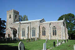
St Margaret, Clenchwarton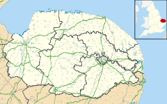
 Clenchwarton
Clenchwarton shown within NorfolkArea 12.77 km2 (4.93 sq mi) Population 2,200 [1] - Density 172 /km2 (450 /sq mi) OS grid reference TF588201 District King's Lynn and West Norfolk Shire county Norfolk Region East Country England Sovereign state United Kingdom Post town KING'S LYNN Postcode district PE34 Dialling code 01553 Police Norfolk Fire Norfolk Ambulance East of England EU Parliament East of England UK Parliament North West Norfolk List of places: UK • England • Norfolk Clenchwarton is a village and civil parish in the English county of Norfolk. It is located on the west side of the River Great Ouse, about 2 km from the river and from the town of King's Lynn on the east side of the river.[2][3]
The civil parish has an area of 12.77 km² and in the 2001 census had a population of 2,200 in 912 households. For the purposes of local government, the parish falls within the district of King's Lynn and West Norfolk.[4]
It once had a Clenchwarton railway station, but this is now closed.
References
- ^ "Neighbourhood Statistics - Clenchwarton CP (Parish)". Office for National Statistics. http://neighbourhood.statistics.gov.uk/dissemination/LeadTableView.do?a=3&b=796826&c=Clenchwarton&d=16&e=15&g=470433&i=1001x1003x1004&m=0&r=1&s=1202223727726&enc=1&dsFamilyId=779. Retrieved 5 February 2008.
- ^ OS Explorer Map 236 - King's Lynn, Downham Market & Swaffham. ISBN 0-755-82036-3
- ^ OS Explorer Map 249 - Spalding & Holbeach. ISBN 0-755-82049-5
- ^ "Census population and household counts for unparished urban areas and all parishes". Office for National Statistics & Norfolk County Council (2001). http://www.norfolk.gov.uk/consumption/groups/public/documents/general_resources/ncc017867.xls. Retrieved 2 December 2005.
External links
Categories:- Villages in Norfolk
- King's Lynn and West Norfolk
- Civil parishes in Norfolk
- Norfolk geography stubs


Wikimedia Foundation. 2010.