- Geography of the Cayman Islands
-
Geography of the Cayman Islands 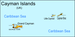
Continent — Region Central America
Caribbean SeaCoordinates 19°30'N, 80°30'W Area Ranked 205th
264 km2 (102 sq mi)
100% land
0% waterBorders Total land borders:
0 km (0 miles)Highest point The Bluff
43 m (141.08 ft)Lowest point Caribbean Sea
0 m (0 ft)Longest river — Largest lake — The Cayman Islands are a British dependency and island country. It is a three-island archipelago in the Caribbean Sea, consisting of Grand Cayman, Cayman Brac, and Little Cayman. Georgetown, the capital of the Cayman Islands is 438 km (272 mi) south of Havana, Cuba ]],[1] and 504 km (313 mi) northwest of Kingston, Jamaica,[2] and are between Cuba and Central America. Georgetown’s geographic coordinates are 19.300° north, 81.383° west. [3]
The Cayman Islands have a land area of 264 km2 (102 sq mi) about 1.5 times the size of Washington, D.C. and just 3 km2 (1.2 sq mi) larger than Saint Kitts and Nevis. The Cayman Islands have a coastline of 160 km (99 mi). The Cayman Islands make a maritime claim of a 200-nautical-mile (370.4 km; 230.2 mi) exclusive fishing zone and a territorial sea of 12 nautical miles (22.2 km; 13.8 mi).[4] [5]
Contents
Geology
The islands are located on the Cayman Rise which forms the northern margin of the Cayman Trough. The trough is the deepest point in the Caribbean Sea and forms part of the tectonic boundary between the North American Plate and the Caribbean Plate. The Cayman Rise extends from southeastern Cuba along the northern margin of the Cayman Trough toward Costa Rica and resulted from Paleocene to Eocene island arc formation with associated volcanism along an extinct subduction zone.[6]
Climate
The Cayman Islands have a tropical marine climate, with a wet season of warm, rainy summers (May to October) and a dry season of relatively cool winters (November to April). Terrain is mostly a low-lying limestone base surrounded by coral reefs.
A major natural hazard is the tropical cyclones that form during the Atlantic hurricane season from July to November.
Climate data for George Town - capital of Cayman Islands Month Jan Feb Mar Apr May Jun Jul Aug Sep Oct Nov Dec Year Average high °C (°F) 26
(79)26
(79)27
(81)28
(82)29
(84)30
(86)31
(88)30
(86)30
(86)29
(84)28
(82)27
(81)28 Daily mean °C (°F) 25
(77)25
(77)26
(79)27
(81)27
(81)28
(82)29
(84)28
(82)28
(82)27
(81)27
(81)25
(77)27 Average low °C (°F) 23
(73)22
(72)23
(73)25
(77)26
(79)27
(81)28
(82)27
(81)26
(79)26
(79)25
(77)23
(73)25 Avg. precipitation days 5 4 4 4 7 7 7 8 9 10 9 6 80 Source: Weatherbase[7] Environmental issues
An important environmental issue is the lack of fresh water resources. Drinking water supplies must be met by rainwater catchment and desalination.
Natural resources
 Cayman sunset from North Side beach
Natural resources include fish and a climate and beaches that foster tourism, which is the islands' major industry. A 2005 estimate of land use determined that the Cayman Islands' had 3.85 percent arable land and no permanent crops.
Districts
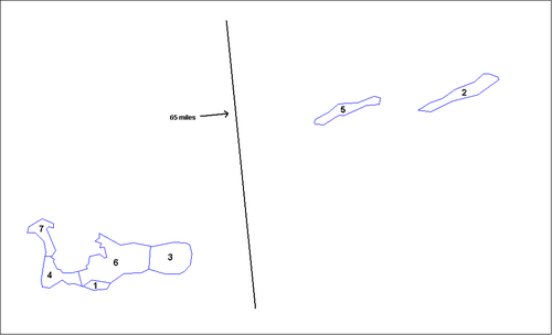
The territory is subdivided into seven districts that are governed by district managers and that have a role as electoral districts and as regional units for statistics. Five of the districts are located on the main island Grand Cayman, and the remaining two correspond to the islands of Little Cayman and Cayman Brac:
Nr. District Area
(km²)Pop.
1999-10-10Pop.
2007 est.Pop.-
density1 Bodden Town 8 5,764 6,918 865 2 Cayman Brac 36 1,822 1,500 42 3 East End 50 1,371 1,552 31 4 George Town 29 20,626 31,785 1096 5 Little Cayman 26 115 200 8 6 North Side 91 1,079 1,258 14 7 West Bay 19 8,243 11,436 602 Cayman Islands 259 39,020 54.649 211 The population is concentrated in the three (south-)western districts George Town (capital), West Bay, and Bodden Town. Those have a population density many times higher than all remaining districts.
References
- ^ "coordinates and total distance". web page. webcrow. http://www.mapcrow.info/Distance_between_Havana_CU_and_George_Town_CJ.html. Retrieved 23 October 2011.
- ^ "coordinates and total distance". web page. webcrow. http://www.mapcrow.info/Distance_between_Kingston_JM_and_George_Town_CJ.html. Retrieved 23 October 2011.
- ^ "coordinates and total distance". web page. webcrow. http://www.mapcrow.info/Distance_between_Kingston_JM_and_George_Town_CJ.html. Retrieved 23 October 2011.
- ^ "Central Intelligence Agency The World Factbook Cayman Islands". web page. US Central Intelligence Agency. https://www.cia.gov/library/publications/the-world-factbook/geos/cj.html. Retrieved 23 October 2011.
- ^ "Central Intelligence Agency The World Factbook St Kitts and Nevis". web page. US Central Intelligence Agency. https://https://www.cia.gov/library/publications/the-world-factbook/geos/sc.html. Retrieved 23 October 2011.
- ^ H. Sigurdsson, et. al., History of circum-Caribbean explosive volcanism: 40Ar/39Ar dating of tephra layers, Ch. 20 in Volume 165, Procedings of the Oceanic Drilling Program, 26 May 2000, ISSN 1096-7451 doi:10.2973/odp.proc.sr.165.2000
- ^ "Weatherbase: Historical Weather for George Town, Cayman Islands". http://www.weatherbase.com/weather/weatherall.php3?s=48387&refer=&units=metric.
External links
- Districts of Cayman Islands, Statoids.com
Sovereign states Antigua and Barbuda · Bahamas · Barbados · Belize · Canada · Costa Rica · Cuba · Dominica · Dominican Republic · El Salvador · Grenada · Guatemala · Haiti · Honduras · Jamaica · Mexico · Nicaragua · Panama · Saint Kitts and Nevis · Saint Lucia · Saint Vincent and the Grenadines · Trinidad and Tobago · United States
Dependencies and
other territoriesAnguilla · Aruba · Bermuda · Bonaire · British Virgin Islands · Cayman Islands · Curaçao · Greenland · Guadeloupe · Martinique · Montserrat · Navassa Island · Puerto Rico · Saint Barthélemy · Saint Martin · Saint Pierre and Miquelon · Saba · Sint Eustatius · Sint Maarten · Turks and Caicos Islands · United States Virgin Islands
Climate of North America Sovereign states Antigua and Barbuda · Bahamas · Barbados · Belize · Canada · Costa Rica · Cuba · Dominica · Dominican Republic · El Salvador · Grenada · Guatemala · Haiti · Honduras · Jamaica · Mexico · Nicaragua · Panama · Saint Kitts and Nevis · Saint Lucia · Saint Vincent and the Grenadines · Trinidad and Tobago · United States
Dependencies and
other territoriesAnguilla · Aruba · Bermuda · Bonaire · British Virgin Islands · Cayman Islands · Curaçao · Greenland · Guadeloupe · Martinique · Montserrat · Puerto Rico · Saint Barthélemy · Saint Martin · Saint Pierre and Miquelon · Saba · Sint Eustatius · Sint Maarten · Turks and Caicos Islands · United States Virgin Islands
Categories:


Wikimedia Foundation. 2010.