- Bootheel
-
This article is about the southeastern corner of the U.S. state of Missouri. For New Mexico Bootheel, see New Mexico Bootheel.
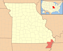 Location of the bootheel region centered on 36°15′N 89°51′W / 36.25°N 89.85°WCoordinates: 36°15′N 89°51′W / 36.25°N 89.85°W
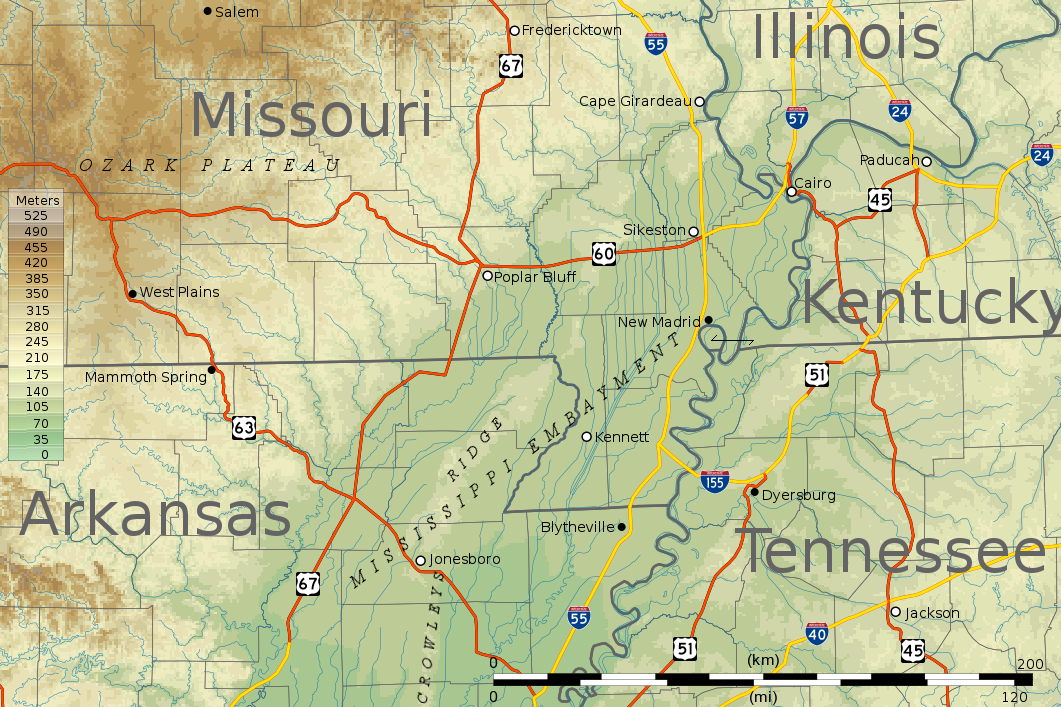
 Topographic map of the bootheel and surrounding areas of Missouri and neighboring states.
The Missouri Bootheel is the southeasternmost part of the state of Missouri, extending south of 36°30’ north latitude, so called because its shape in relation to the rest of the state resembles the heel of a boot. Strictly speaking, it is composed of the counties of Dunklin, New Madrid, and Pemiscot. However, the term is sometimes used to refer to the entire southeastern lowlands of Missouri located within the Mississippi Embayment, which includes parts of Butler, Mississippi, Ripley, Scott, Stoddard and extreme southern portions of Cape Girardeau and Bollinger counties. The largest cities in the region are Sikeston and Kennett.
The Bootheel along with the Oklahoma-Kansas-Missouri border near the 37th parallel north form the two biggest jogs in a nearly straight line of state borders that starts on the Atlantic Ocean with the Virginia–North Carolina border extending all the way to the tristate border of Nevada, Arizona and Utah.
Contents
History
When Missouri was added to the Union, its original border proposal was to be an extension of the 36°30′ parallel north that formed the border between Kentucky and Tennessee, which would have excluded the Bootheel. However, John Hardeman Walker, a pioneer planter in what is now Pemiscot County, argued that the area had more in common with the Mississippi River towns of Cape Girardeau, Ste. Genevieve and St. Louis in Missouri than with its proposed incorporation in Arkansas Territory. The border was dropped about 50 miles to the 36th parallel north. It follows that parallel about 30 miles until intersecting the St. Francis River, then follows the river back up to about the 36°30′ parallel just west of Campbell, Missouri.
According to an apocryphal story in various versions, the bootheel was added because of the request of some Missourian to remain in the state "as he had heard it was so sickly in Arkansas;" ""...full of bears and panthers and copperhead snakes, so it ain't safe for civilized people to stay there over night even." Another folktale has the adaptation made by a lovestruck surveyor to spare the feelings of a widow living fifty miles south of the Missouri border, but unaware of it. At one time, the area was known locally as "Lapland, because it's the place where Missouri laps over into Arkansas".[1]
Geography and geology
Available samples from the Bootheel and most of the southeastern Missouri counties demonstrate late Tertiary (more than 1.8 mya) to Quaternary (1.8 mya to present) geology, much younger than neighboring highlands. The lowest point in the state is in southwestern Dunklin County along the St. Francis River near Arbyrd, Missouri, at 230 feet above sea level. The bootheel area is notable for being the epicenter of the 1811-1812 New Madrid Earthquakes, some of the largest earthquakes ever felt in the United States.
Swamp reclamation and flooding
The Bootheel lies in the flood plain between the Mississippi and St. Francis rivers; the land is very flat and is now used for predominantly agricultural purposes. Prior to the 20th century, it was mostly swampy forestland not settled by European Americans. As glaciers receded towards the end of the Ice Age and turned ice into liquid, the Mississippi River grew longer and wider. Over time, the silt deposits of the Mississippi created some of the most fertile soil in the world, ideal for agriculture. The areas around the Mississippi are composed of thick regolith that is around 100 metres (330 ft) thick.
Between 1893 and 1989, developers cut about 85% of the native forests. The entire landscape was transformed into farmland by extensive logging, draining of the watershed, channelization, and the construction of flood control structures. High levees along both river courses, an extensive system of drainage ditches and diversion channels, and controlled lakes, pumping stations and cutoffs protect the area from flooding. The soils are predominantly a rich and deep glacial loess, alluvial silt, and a sandy loam, well-suited for agricultural use. The levees have changed the nature of the rivers, however, and in some cases aggravated flooding problems. They also prevent regular silt deposits, as they have increased the speed of the rivers. The reduction in wetlands has reduced important habitats for many species of migratory birds and a variety of fish and animals.
Flooding is a major concern along the Mississippi River. With such a large river basin and the vast discharge of water, the river makes the towns along its banks highly susceptible to frequent flooding. The National Weather Service reported that from 1980 to 2002, nine floods in the United States had total losses exceeding one billion dollars. In terms of monetary loss and impact on society, the Great Flood of 1993 was the worst.[2]
New Madrid fault zone
Earthquakes have long been frequent in the area. The New Madrid Fault Zone (pronounced New MAD-rid) is named for the town of New Madrid in the Bootheel. This fault zone is entirely hidden beneath the deep alluvial deposits of the Mississippi embayment and, unlike the San Andreas Fault in California, is not visible anywhere. This fault zone was responsible for an extremely powerful series of earthquakes that rocked the area in 1811 and 1812, known collectively as the New Madrid Earthquake, which reportedly rang church bells along the East Coast. Subsidence formed Reelfoot Lake across the Mississippi River in West Tennessee. An eyewitness of the earthquakes of 1811 and 1812 noted,
“Great fissures opened the earth, geysers show mud and rocks hundreds of feet in the air, new hills and ridges heaved up out of the ground, and the river itself ran red with brimstone and sulfur. Whole islands in the river disappeared, the forests went under, the tall oaks snapped like twigs, and violent winds tossed bundles of fallen timbers. Deafening thunder rang to the heavens. Animals went crazy; thousands of birds hovered and screamed”.[3]
The states of Missouri, Arkansas, Mississippi, Alabama, Tennessee, Kentucky, Illinois, and Indiana felt the brunt of this quake, ruining lives and leaving residents in fear of aftershocks and possible larger quakes. To this day, the New Madrid Seismic Zone is still active and produces small earthquakes very frequently. Scientists have estimated that a strong earthquake is inevitable to happen again and is overdue. Residents of the area are aware of the risk, but critics say they are not well prepared for a disaster. William Atkinson, author of The Next New Madrid Earthquake, writes,
“The area is well overdue for a moderately powerful tremor- which will cause major damage and undoubtedly some casualties...With each passing year, the inevitable earthquake is becoming more powerful, while the state of readiness in the Mississippi Valley remains woefully inadequate”.
Given the population in the area, even a moderately sized earthquake would be disastrous.[4]
Culture and economy
The Bootheel is on the edge of the Mississippi Delta culture that produced the Delta blues. Its relatively large black population makes it distinct from the rest of rural Missouri, and the area has a unique rural black culture reflected in its music, churches and other traditions. The Black population ranges from about 26% in Pemiscot County, to 15% in New Madrid County and about 9% in Dunklin County.
The Bootheel once had a reputation for lawlessness. Remote settlements along the river banks, miles from paved roads, provided an ideal environment (and market) for moonshining and bootlegging.
Culturally, the Bootheel is considered more Southern than Midwestern. It is part of the Mid-South, a region focused on the Memphis metropolitan area. Definitions of the Mid-South vary but in general include west Tennessee, north Mississippi, northeast Arkansas, and the Missouri Bootheel.[5] The locations of the region's television stations reflect this:
- the CBS and Fox affiliates are located in Cape Girardeau,
- the ABC affiliate is located in Harrisburg, Illinois, and
- the NBC affiliate is in Paducah, Kentucky.
The farther south in the Bootheel, the more pronounced is residents' identification with the South.[citation needed] The network television affiliates in Memphis, Tennessee, which is the largest city for 200 miles, or in Jonesboro, Arkansas, often have a greater audience than those in Illinois, Kentucky, or Cape Girardeau.
Economically, the area is one of the more impoverished parts of Missouri and does not enjoy the benefits of tourism in the nearby Ozark Mountains. There is some manufacturing, but the area is primarily agricultural. Because of its alluvial past, the area's rich soil is ideal for growing soybeans, rice and cotton. Some "truck crops" are grown, most notably various types of melons, especially watermelons. A limited amount of livestock is raised, and in contrast to much of the rest of Missouri, there are very few fences.
No large cities are located in the Bootheel. Sizable towns include Kennett (the birthplace of singers Sheryl Crow, Trent Tomlinson, and David Nail) and Sikeston (the birthplace of professional athletes James Wilder, Brandon Barnes, and Blake DeWitt), which is partially in Scott County and New Madrid County. Cape Girardeau and Poplar Bluff are often grouped together with the bootheel due to the influence the two cities have had on the development of the region, despite not being in the physical area of the bootheel. Hornersville, a small town in southern Dunklin County, was home to William H. "Major" Ray, a one-time 19th-century circus "midget". He later became known as the representative of the Buster Brown shoe brand. He and his wife, Jennie, are buried in a cemetery in Hornersville.[6]
The small towns of Senath and Arbyrd are also located in Dunklin County. They are home to a locally celebrated ghost light, sometimes called the "Senath Light" or "Arbyrd light". It occurs between these two towns and closer to Hollywood near the Lulu Church and Cemetery.[7][8]
The Missouri Bootheel is the home place of two members of the musical group the Kentucky Headhunters, Doug and Ricky Phelps. They received their education at Southland C-9, the consolidated schools of Arbyrd and Cardwell, Missouri. They performed at the Cotton Pickin Festival in the small town of Arbyrd; a place where they spent much time while growing up. They both performed as Brother Phelps, and then Doug came back and performed with The Kentucky Headhunters. This festival is a major attraction and draws a huge crowd for a town of only about 550 people. Other prominent acts at Arbyrd include T. Graham Brown and the Bellamy Brothers.[9][10][11]
Also in the northern part of Dunklin County lies the town of Malden, the home of country/rockabilly singer Narvel Felts. Felts' music has played worldwide, as he continues to tour. George (Richardson) Richey is a well-known country music producer.[citation needed] Richey was married to Tammy Wynette. Tammy came to claim Malden as her own and appeared annually at the Fourth of July celebrations for years.
During the American Civil War, a number of battles took place in this area, most notably the Battle of Island No. 10.
References
- ^ Randolph, Vance (1957), The Talking Turtle and Other Ozark Folk Tales, New York: Columbia University Press, pp. 36–38, 191–192.
- ^ Orne, Anthony R. (2002), The Physical Geography of North America, Oxford: Oxford University Press, ISBN 0195111079.
- ^ Hall, B. C.; Wood, C. T. (1992), Big Muddy: Down the Mississippi Through America’s Heartland, New York: Penguin Press, ISBN 0452270103.
- ^ Atkinson, William (1989), The Next New Madrid Earthquake: A Survival Guide for the Midwest, Carbondale, IL: Southern Illinois University Press, ISBN 0809313197
- ^ History of the National Weather Service: Memphis, Tennessee, National Weather Service
- ^ Roadsideamerica.com
- ^ Ghosts.org
- ^ Kait8.com
- ^ DDDnews.com
- ^ DDDnews.com
- ^ People.com
External links
- How Did ... Missouri Come To Include the "Bootheel"?, from Missouri's Office of the Secretary of State
- Bootheel map and statistics, from Missouri's Department of Economic Development
- Missouri Bootheel Regional Consortium
Categories:- Border irregularities of the United States
- Geography of Dunklin County, Missouri
- Geography of New Madrid County, Missouri
- Geography of Pemiscot County, Missouri
- Regions of Missouri
- Regions of the Southern United States

Wikimedia Foundation. 2010.