- Maryland Heights, Missouri
-
For other uses, see Maryland Heights (disambiguation).
Maryland Heights, Missouri — City — Motto: Where Life is Celebrated Location of Maryland Heights, Missouri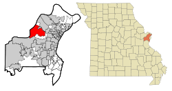
Coordinates: 38°43′10″N 90°26′51″W / 38.71944°N 90.4475°WCoordinates: 38°43′10″N 90°26′51″W / 38.71944°N 90.4475°W Country United States State Missouri County St. Louis Area - Total 23.6 sq mi (61.0 km2) - Land 21.4 sq mi (55.4 km2) - Water 2.2 sq mi (5.7 km2) Elevation 528 ft (161 m) Population (2010) - Total 27,472 - Density 1,166.4/sq mi (450.4/km2) Time zone Central (CST) (UTC-6) - Summer (DST) CDT (UTC-5) FIPS code 29-46586[1] GNIS feature ID 0756359[2] Website http://www.marylandheights.com Maryland Heights is a second-ring west-central suburb of St. Louis, located in St. Louis County, Missouri, United States. The population was 27,472 at the 2010 census.[3] The city was incorporated in 1985. Edwin L. Dirck was elected the city's first mayor. Mark M. Levin has been City Administrator since August 1985.
Contents
Geography
Maryland Heights is located at 38°43′10″N 90°26′51″W / 38.719551°N 90.447467°W (38.719551, -90.447467).[4] According to the United States Census Bureau, the city has a total area of 23.6 square miles (61 km2), of which 21.4 square miles (55 km2) is land and 2.2 square miles (5.7 km2), or 9.29%, is water.
Government
The city of Maryland Heights is a Third-Class Statutory City. It is governed by a Mayor who serves a four year term and a City Council made up of eight members. The city is divided into four wards.[5] Two council-people are elected from each ward to serve on a city council for two year terms. The city is constructing a new government center to be completed in the summer of 2008.[6] The city has offered internships in public administration since 1986.[7]
Demographics
Historical populations Census Pop. %± 1970 8,805 — 1980 5,676 −35.5% 1990 25,407 347.6% 2000 25,756 1.4% 2010 27,472 6.7% sources:[8][3][9] As of the census[1] of 2000, there were 25,756 people, 11,302 households, and 6,419 families residing in the city. The population density was 1,204.4 people per square mile (464.9/km2). There were 11,846 housing units at an average density of 553.9 per square mile (213.8/km2). The racial makeup of the city was 85.35% White, 5.58% African American, 0.20% Native American, 7.11% Asian, 0.03% Pacific Islander, 0.71% from other races, and 1.02% from two or more races. Hispanic or Latino of any race were 2.33% of the population.
There were 11,302 households out of which 25.8% had children under the age of 18 living with them, 44.2% were married couples living together, 9.5% had a female householder with no husband present, and 43.2% were non-families. 33.8% of all households were made up of individuals and 5.5% had someone living alone who was 65 years of age or older. The average household size was 2.25 and the average family size was 2.94.
In the city, the population was spread out with 21.5% under the age of 18, 9.8% from 18 to 24, 37.2% from 25 to 44, 22.0% from 45 to 64, and 9.5% who were 65 years of age or older. The median age was 34 years. For every 100 females there were 97.7 males. For every 100 females age 18 and over, there were 96.1 males.
The median income for a household in the city was $48,689, and the median income for a family was $58,487. Males had a median income of $40,700 versus $30,613 for females. The per capita income for the city was $24,918. About 3.8% of families and 5.3% of the population were below the poverty line, including 4.6% of those under age 18 and 8.2% of those age 65 or over.
With nearly 2,000 businesses located in the city, the daytime population is estimated at 100,000.[citation needed]
Economy
At one time, Express Scripts had its headquarters in Maryland Heights.[10][11] Express Scripts built a new headquarters on the grounds of the University of Missouri-St. Louis in 2007.[12]
Top employers
According to the city's 2009 Comprehensive Annual Financial Report,[13] the top employers in the city are:
# Employer # of Employees 1 Edward Jones 2,443 2 Harrah's St. Louis 1,891 3 Magellan Health Services 1,480 4 Talx 1,369 5 Ally Financial 1,005 6 UnitedHealthcare 900 7 Elsevier (Mosby) 732 8 Monsanto 600 9 World Wide Technology 539 10 Schnucks 525 Attractions, parks and recreation
The city of Maryland Heights operates four parks as well as Aquaport, a waterpark; Sportport, a multi-use recreational facility; and Dogport, a park for dogs.
Creve Coeur County Park
Creve Coeur Lake Memorial Park is operated by St. Louis County and was a summer resort in the early 1900s. It features a 320-acre (1.3 km2) lake as well as the picturesque "Dripping Springs" waterfall. It was St. Louis County's first park.
Vago Community Park
Vago Park is a 20-acre (81,000 m2) park located at the intersection of Fee Fee Road and Midland Avenue. It features three playgrounds, a paved walking trail, a sand volleyball court, three pavilions, a gazebo and picnic areas outfitted with barbecue grills. Visitors will want to be sure to note the "Veterans Memorial Walk," a sidewalk made of bricks imprinted with the names of Maryland Heights residents who have served in our country's armed forces.
Gerald A. Eise Memorial Park
Eise Park is located at the intersection of Glenview Drive and Bourbon Street, near Rose Acres Elementary School. It contains one pavilion seating about 25 people, a sand volleyball court, a playground, several picnic tables with barbecue grills, a walking path, a basketball slab, and restrooms.
Quiet Hollow Park
Quiet Hollow Park is a small park at the intersection of Marine Avenue and McKelvey Road.
Parkwood Park
Parkwood Park is located on 3145 Parkwood Lane, next to Parkwood Elementary School. It features a 0.7-mile (1.1 km) paved walking trail with fitness stations, a playground, green space, restrooms and a small parking lot.
Westport Plaza
Westport Plaza is a 700,000+ square foot development featuring dining, entertainment venues, businesses and even radio stations. Westport is located at the intersection of Page Avenue and I-270 in the west-central area of St. Louis County.
Harrah's Casino
Maryland Heights is home to St. Louis County's first casino, Harrah's, which opened in 1997 in the Riverport area.
References
- ^ a b "American FactFinder". United States Census Bureau. http://factfinder.census.gov. Retrieved 2008-01-31.
- ^ "US Board on Geographic Names". United States Geological Survey. 2007-10-25. http://geonames.usgs.gov. Retrieved 2008-01-31.
- ^ a b "Race, Hispanic or Latino, Age, and Housing Occupancy: 2010 Census Redistricting Data (Public Law 94-171) Summary File (QT-PL), Maryland Heights city, Missouri". U.S. Census Bureau, American FactFinder 2. http://factfinder2.census.gov. Retrieved October 24, 2011.
- ^ "US Gazetteer files: 2010, 2000, and 1990". United States Census Bureau. 2011-02-12. http://www.census.gov/geo/www/gazetteer/gazette.html. Retrieved 2011-04-23.
- ^ City of Maryland Heights' Official Website
- ^ City of Maryland Heights' Official Website
- ^ http://www.marylandheights.com/documents/City%20Newsletter/August%20City%202006.pdf
- ^ "CENSUS OF POPULATION AND HOUSING (1790-2000)". U.S. Census Bureau. http://www.census.gov/prod/www/abs/decennial/index.html. Retrieved 2010-07-17.
- ^ Census numbers enumerated in 1970 and 1980 is prior to incorporation.
- ^ "EXPRESS SCRIPTS INC." St. Louis Post-Dispatch. May 18, 1998. Business Plus. Five Star Lift Edition. Page 38. Retrieved on December 2, 2009.
- ^ "Article: St. Louis Post-Dispatch Business Briefs Column." St. Louis Post-Dispatch. October 3, 2003. Retrieved on December 2, 2009.
- ^ "Express Scripts to Build New Headquarters." Express Scripts at St. Louis Regional Chamber & Growth Association. September 8, 2005. Retrieved on December 2, 2009.
- ^ City of Maryland Heights CAFR
External links
Greater St. Louis Illinois · Missouri · United States of America Topics 
Central city Largest cities
(over 20,000 in 2000)Affton CDP · Alton · Ballwin · Belleville · Chesterfield · Collinsville · East St. Louis · Edwardsville · Ferguson · Florissant · Granite City · Hazelwood · Kirkwood · Maryland Heights · Mehlville CDP · Oakville CDP · O'Fallon, Illinois · O'Fallon, Missouri · Saint Charles · St. Peters · Spanish Lake CDP · University City · Webster Groves · WildwoodLargest towns
and villages
(over 10,000 in 2000)Arnold · Bellefontaine Neighbors · Berkeley · Bridgeton · Cahokia · Clayton · Concord CDP · Crestwood · Creve Coeur · Fairview Heights · Farmington · Festus · Glen Carbon · Godfrey · Jennings · Lake St. Louis · Lemay CDP · Manchester · Overland · St. Ann · Swansea · Town and Country · Washington · Wentzville · Wood RiverMissouri Counties Franklin · Jefferson · Lincoln · St. Charles · Saint Francois · St. Louis City · St. Louis County · Warren · WashingtonIllinois Counties Subregions  State of Missouri
Jefferson City (capital) Topics Government · Delegations · Geography · Transportation · History · People · Visitor Attractions
Society Regions Bootheel · Crowley's Ridge · Dissected Till Plains · Four State Area · Henry Shaw Ozark Corridor · Honey Lands · Lead Belt · Lincoln Hills · Little Dixie · Loess Hills · Mid-Missouri · Mississippi Embayment · Missouri Rhineland · Northern Plains · Osage Plains · Ozark Plateau · Platte Purchase · Pony Express · St. Francois Mountains · Westplex
Metro areas Columbia · Jefferson City · Joplin · Kansas City · Springfield · St. Joseph · St. Louis
Largest cities Kansas City · St. Louis · Springfield · Independence · Columbia · Lee's Summit · O'Fallon · St. Joseph · St. Charles · St. Peters · Blue Springs · Florissant · Joplin · Chesterfield · Jefferson City · Cape Girardeau · Wildwood · University City · Ballwin · Raytown · Liberty · Wentzville · Kirkwood · Maryland Heights · Hazelwood
Counties and
independent citiesAdair · Andrew · Atchison · Audrain · Barry · Barton · Bates · Benton · Bollinger · Boone · Buchanan · Butler · Caldwell · Callaway · Camden · Cape Girardeau · Carroll · Carter · Cass · Cedar · Chariton · Christian · Clark · Clay · Clinton · Cole · Cooper · Crawford · Dade · Dallas · Daviess · DeKalb · Dent · Douglas · Dunklin · Franklin · Gasconade · Gentry · Greene · Grundy · Harrison · Henry · Hickory · Holt · Howard · Howell · Iron · Jackson · Jasper · Jefferson · Johnson · Knox · Laclede · Lafayette · Lawrence · Lewis · Lincoln · Linn · Livingston · Macon · Madison · Maries · Marion · McDonald · Mercer · Miller · Mississippi · Moniteau · Monroe · Montgomery · Morgan · New Madrid · Newton · Nodaway · Oregon · Osage · Ozark · Pemiscot · Perry · Pettis · Phelps · Pike · Platte · Polk · Pulaski · Putnam · Ralls · Randolph · Ray · Reynolds · Ripley · St. Charles · St. Clair · St. Francois · St. Louis (City) · St. Louis (County) · Ste. Genevieve · Saline · Schuyler · Scotland · Scott · Shannon · Shelby · Stoddard · Stone · Sullivan · Taney · Texas · Vernon · Warren · Washington · Wayne · Webster · Worth · Wright
Categories:- Cities in St. Louis County, Missouri
- Communities on U.S. Route 66


Wikimedia Foundation. 2010.