- Glenelg, Highland
-
Coordinates: 57°12′43″N 5°37′26″W / 57.212°N 5.624°W
Glenelg Scottish Gaelic: Gleann Eilg 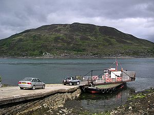
Glenelg-Kylerhea ferry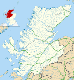
 Glenelg
Glenelg shown within the Highland council areaPopulation 283 [1] OS grid reference NG812192 Council area Highland Country Scotland Sovereign state United Kingdom Post town KYLE Postcode district IV40 Dialling code 01599 EU Parliament Scotland List of places: UK • Scotland • Glenelg (Scottish Gaelic: Gleann Eilg) is a village in Lochalsh, Highland council area, in western Scotland.
Contents
Geography
Glenelg is located by the Kyle Rhea narrows, where Skye is closest to the mainland. Road access is by the 339m Bealach (pass) Ratagain from Shiel Bridge, on the main Inverness to Skye road.
Its proximity to Skye meant that Glenelg was formerly of more strategic importance. Cattle reared on Skye were routinely made to swim to the mainland before being herded to market along the drovers' road to Kinlochhourn and on to the Lowlands.
Following the initial Jacobite risings, Glenelg was chosen as one of four sites in the Highlands for a military barracks. These were completed in 1725 and a military road soon linked Glenelg to the rest of General George Wade's road network. Ultimately unsuccessful in preventing the 1745 uprising, and not needed after the Highland Clearances, the Bernera Barracks are now ruined.
A person from Glenelg is known in Gaelic as an Eilgeach.
Ferry
Between March and October, a small vehicle ferry connects to Kyle Rhea on Skye, across the powerful currents of the narrows. The ferry used on the crossing since 1982 is the Glenachulish, the last turntable ferry in operation.[2] Built in 1969 for the Ballachulish crossing, by the Ailsa Shipbuilding Company in Troon, she is now operated by a local Community Interest Company. The ferry can transport six cars plus foot passengers on the open deck. Cars are turned on its unique hand-turned turntable. When the Ballachulish Bridge opened in 1975, she became the relief vessel for Corran, Kylesku and Kessock, near Inverness.[2]
 Dun Troddan
Attractions
The ferry is a tourist attraction in itself. The former structure of the Sandaig lighthouse has now been erected on the slipway to serve as a souvenir shop. Glenelg also offers the chance to ride The MacAskill, a very popular activity among locals and residents of the surrounding villages.
Glenelg attracts tourists to the remains of two of the best-preserved brochs (Dun Telve and Dun Troddan) on mainland Scotland.
Etymology
Although the name nowadays refers to the whole district, it is likely that it originally referred only to the glen containing the brochs. The specific element of the name (Eilg) is found elsewhere, such as in Elgin (Gaelic Eilginn) and is generally accepted as being a kenning for Ireland. Other such names include Banavie, Banff, Atholl, Lochearn, Auldearn, and show Gaelic settlers using the same migrant naming practice as gives us placenames such as New Caledonia and New York.
Sandaig
The retreat of the author, Gavin Maxwell (known as Camusfeàrna in his books), is about six miles south west of Glenelg. The Sandaig Islands are a small group of islets just off the point in the Sound of Sleat.
References
- ^ 2001 Census
- ^ a b "Glenelg Ferry". Gazetteer for Scotland. http://www.undiscoveredscotland.co.uk/skye/glenelgferry/. Retrieved 17 October 2009.
Traditional provinces and districts of Scotland Major districts (former counties, provincial lordships and rural deaneries) The Aird · Annandale · Angus · Argyll · Atholl · Boyne · Buchan · Badenoch · Breadalbane · Caithness · Carrick · Clydesdale (or Strathclyde) · Cowal · Cunningham · Desnes · Eskdale · Farines · Fife · Fothriff · Galloway · Garioch · Garmoran · The Glenkens · Gowrie · Kintyre · Knapdale · Kyle · Lauderdale · Lennox · Liddesdale · Lochaber · Lorn · Lothian · Mar · Mearns · Menteith · Merse · Moray · Nithsdale · The Rhinns · Ross (Easter and Wester) · Stormont · Strathavon · Strathbogie · Strathearn · Strathgryfe · Strathnaver · Strathspey · Sutherland · Teviotdale · Tweeddale
Minor districts Applecross · Appin · Ardgour · Ardmeanach · Ardnamurchan · Assynt · Avondale · Balquhidder · Benderloch · The Black Isle · Braemar · Coigach · Cromar · Cromdale · Douglasdale · Durness · Eddrachilles · Enzie · Ettrickdale · Ewesdale · Formartine · Gairloch · Glen Albyn · Glen Almond · Glen Cassley · Glen Clova · Glen Dochart · Glenelg · Glen Esk · Glengarry · Glen Lethnot · Glen Lyon · Glen Moriston · Glen Orchy · Glen Prosen · Glenshee · Glen Spean · Glen Urquhart · Gruinard · Howe of Fife · Howe of the Mearns · Kintail · Kintyre · Knoydart · Lochalsh · Loch Broom · Locheil · The Machars · Midmar · Moidart · Morar · Morven · Muir of Ord · Rannoch Moor · Rhinns of Kells · Strathallan · Strathardle · Strathbran · Strathbraan · Strathcarron (Forth) · Strathcarron (Oykel) · Strathconon · Strathdearn · Strathdeveron · Strathdee (Deeside) · Strathdon · Strathfarrar · Strath Gartney · Strathglass · Strathisla · Strathmore · Strath of Kildonan · Strath Oykel · Strath Tay · Strathyre · Sunart · Trossachs
Insular districts
For smaller islands, usually districts in their own right, see List of Scottish islandsBorder Areas Brochs Shetland Orkney Hebrides Dun Carloway · Dun BeagHighlands Southern Scotland Categories:- Populated places in Lochalsh
- Forts in Scotland
- Brochs
- Archaeological sites in Highland (council area)
- Ferries of Scotland


Wikimedia Foundation. 2010.