- New Zealand State Highway 8
-
State Highway 8

Route information Maintained by New Zealand Transport Agency Length: 457 km (284 mi) Major junctions CW end:  SH 1 at Washdyke
ACW end: SH 1 at ClarksvilleLocation Primary
destinations:Fairlie, Lake Tekapo, Twizel, Omarama, Cromwell, Alexandra, Roxburgh, Lawrence Highway system New Zealand State Highways
Motorways and Expressways • List • Unused←  SH 7
SH 7SH 10  →
→State Highway 8 is one of New Zealand's former eight national highways. It forms an anticlockwise loop through the southern scenic regions of the Mackenzie Basin and Central Otago, starting and terminating in junctions with State Highway 1. Distances are measured from north to south.
For most of its length SH8 is a two-lane single carriageway, with at-grade intersections and property accesses directly off the road, both in rural and urban areas.
Contents
Route
 NZSH 8 runs through rugged terrain, such as the rocky hill country south of Alexandra.
 State Highway 8 runs through Lawrence.
Main route
The State Highway 8 route (as of 2010):
The highway leaves SH1 at Washdyke, an industrial suburb of Timaru, travelling initially northwest towards the town of Fairlie. From here the route tends westward and rapidly increases in altitude, passing the southern end of the two great Mackenzie Basin lakes of Tekapo and Pukaki.
From Pukaki the highway turns southwest across the upper reaches of the Waitaki Valley, passing through the former hydroelectricity service town of Twizel and Omarama before again climbing to cross the Lindis Pass, which, at 971 metres, is the highest point on the highway's path. The highway winds along the valley of the Lindis River, reaching the upper Clutha River not far from Tarras.
From here, the highway runs close to the eastern shore of the man-made Lake Dunstan before passing the historic town of Cromwell. The highway turns south as it travels through the Cromwell Gorge passing the country's largest hydroelectric dam, the Clyde Dam at Clyde. The highway continues along the Clutha Valley through the town of Alexandra and past Lake Roxburgh to the town of Roxburgh. Much of this part of the highway's journey is past fruit orchards, and historic gold-diggings from the Central Otago Gold Rush.
From Roxburgh, the highway turns southeastward, passing Ettrick, Raes Junction and Beaumont, where it turns away from the Clutha, before reaching Lawrence, close to the original strike in the Central Otago Gold Rush. From here, the highway continues past Waitahuna and the twisting Manuka Gorge, reaching the plain of the Tokomairiro River at Clarksville, three kilometres south of Milton.
Highway spurs
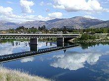 Deadmans Point bridge, looking towards Cromwell
State Highway 8 has two spurs: State Highway 8A and State Highway 8B. These two spurs connect the highway with State Highway 6, which lies on the western bank of Lake Dunstan. State Highway 8A runs for 23 km from SH6 at Luggate to connect with SH8 close to Tarras. State Highway 8B runs for just 2.6 km from SH8 at Deadmans Point across the lake to the town of Cromwell.
Route changes
The course of SH8 between Clyde and Tarras was substantially altered during the 1980s as part of the construction of the Clyde Dam, which flooded much of the Cromwell Gorge, including the former route of the highway. A completely new section was built between Clyde and Cromwell; for SH8B the old single-lane bridge crossing the Clutha was replaced with a new two-lane bridge approximately 1.5 km to the north.
Statistics
In 2006, SH8 had an annual average daily traffic volume (AADT - daily estimate) of between 1,188 vehicles at Bendigo, and 4,897 vehicles on the Clyde side of Alexandra. Over the eleven sites measured, between 9.0% and 15.3% of the vehicles were classified as heavy (3.5 tonnes or greater). For the spurs, SH8A AADT ranged from 646 to 858 vehicles, while the volume of vehicles on SH8B was 3,930 on Deadmans Point Bridge, and 4,500 near the SH6 junction.[1]
Major intersections
Territorial authority Location km Destinations Notes Timaru District Washdyke 0 SH 1 north
Temuka, ChristchurchSH 8 begins SH 1 south
Timaru, DunedinMackenzie District Fairlie 57  SH 79
SH 79
Geraldine, ChristchurchAlternative route to Christchurch, bypassing Timaru Lake Pukaki 146  SH 80
SH 80
Glentanner, Aoraki/Mt CookWaitaki District Omarama 185  SH 83
SH 83
Kurow, OamaruLindis Pass
972 m (3,189 ft)Central Otago District Tarras  SH 8A
SH 8A
Wanaka, West CoastCromwell  SH 8B
SH 8B
Cromwell, QueenstownAlexandra  SH 85
SH 85
Ranfurly, DunedinRaes Junction  SH 90
SH 90
Tapanui, GoreIntersection lies on the border between the two districts Clutha District Clarksville 460 SH 1 north
Milton, DunedinSH 8 ends SH 1 south
Balclutha, InvercargillSee also
- List of New Zealand State Highways
- List of roads and highways, for notable or famous roads worldwide
References
- ^ "Traffic Data Booklet 2002 - 2006" (PDF). Transit New Zealand. May 2007. Archived from the original on 2008-04-11. http://web.archive.org/web/20080411172718/http://www.transit.govt.nz/content_files/shtv/SHTV-2002-2006.pdf. Retrieved 2007-12-09.
New Zealand highways New Zealand State Highway network · List of New Zealand State Highways National SH 1 (incl. SH 1B) · SH 2 (incl. SH 2A, SH 2B) · SH 3 (incl. SH 3A) · SH 4 · SH 5 · SH 6 (incl. SH 6A) · SH 7 (incl. SH 7A) · SH 8 (incl. SH 8A, SH 8B)
North Island SH 10 · SH 11 · SH 12 · SH 14 · SH 15A · SH 16 · SH 17 · SH 18 · SH 20 · SH 21 · SH 22 · SH 23 · SH 24 · SH 25 (incl. SH 25A) · SH 26 · SH 27 · SH 28 · SH 29 · SH 30 (incl. SH 30A) · SH 31 · SH 32 · SH 33 · SH 34 · SH 35 · SH 36 · SH 37 · SH 38 · SH 39 · SH 41 · SH 43 · SH 44 · SH 45 · SH 46 · SH 47 · SH 48 · SH 49 · SH 50 (incl. SH 50A) · SH 53 · SH 54 · SH 56 · SH 57 · SH 58South Island Touring Routes Twin Coast Discovery Highway · Thermal Explorer Highway · Pacific Coast Highway · Classic New Zealand Wine Trail · Alpine Pacific Triangle · Great Alpine Highway · Foothills Scenic Route · Southern Scenic RouteCategories:- State highways in New Zealand


Wikimedia Foundation. 2010.